المستندات والموارد - نتائج البحث
نتائج البحث

خريطة كوكبة الدلفين
صورة
الشرح: كوكبة الدلفين مع نجومها الأكثر إشراقاً والكوكبات المحيطة بها. يحيط بكوكبة الدلفين (في اتجاه عقارب الساعة من الأعلى): فولبيكولا، ساجيتا، أكيلا، أكويلا، أكواريوس، إيكوليوس وبيجاسوس. وتعتبر الدلفين كوكبة صغيرة نسبياً مع عدد قليل من النجوم اللامعة.
تقع كوكبة الدلفين شمال خط الاستواء السماوي، وبالتالي فإن الكوكبة بأكملها مرئية في وقت ما من السنة في جميع المناطق باستثناء المناطق القطبية. من الأفضل مشاهدة الكوكبة في المساء في أوائل الخريف في نصف الكرة الشمالي وأوائل الربيع في نصف الكرة الجنوبي.
يقع الحشد النجمى الكوري NGC 6934 في الدلفين. وقد تم تمييزه هنا بدائرة صفراء عليها علامة زائد.
المحور y في هذا الرسم البياني مقيس بدرجات الانحراف مع وضع الشمال في الأعلى والمحور x مقيس بساعات الصعود إلى اليمين مع وضع الشرق إلى اليسار. ترتبط أحجام النجوم المُحدَّدة هنا بالقدر الظاهري للنجم، وهو مقياس لسطوعه الظاهري. تمثل النقاط الأكبر حجماً النجوم الأكثر سطوعاً. تشير الحروف اليونانية إلى ألمع النجوم في الكوكبة. وهي مُرتَّبة حسب السطوع حيث يُسمَّى النجم الأكثر سطوعًا ألفا، وثاني ألمع نجم بيتا، إلخ، على الرغم من أن هذا الترتيب لا يُتَّبع دائمًا بدقة. تشير خطوط الحدود المنقطة إلى الحدود التي وضعها الاتحاد الفلكي الدولي للمجموعات النجمية والخطوط الخضراء الصلبة تشير إلى أحد الأشكال الشائعة المستخدمة لتمثيل أشكال المجموعات النجمية. لا تظهر حدود الكوكبات ولا الخطوط التي تربط بين النجوم على السماء.
المصدر: بتصرف من قبل مكتب الاتحاد الفلكي الدولي للاتحاد الفلكي الدولي للتعليم من النسخة الأصلية للاتحاد الفلكي الدولي والاتحاد الفلكي الدولي وسكاي آند تليسكوب
رابط المصدر
مصطلحات المعجم:
القدرالظاهري , الإحداثيات السماوية , خط الاستواء السماوي , مجموعة نجمية او حشد نجمى , الميل , العنقود النجمي الكروي , المطلع المستقيم , الدلو
فئات:
علم الفلك بالعين المجردة
الترخيص: المشاع الإبداعي نَسب المُصنَّف 4.0 دولي (CC BY 4.0) المشاع الإبداعي نَسب المُصنَّف 4.0 دولي (CC BY 4.0) أيقونات
ملف
( صورة
68.66 kB)
ملف PDF
(PDF file
162.12 kB)

Indus Constellation Map
صورة
الشرح: The constellation Indus with its bright stars and surrounding constellations. Indus is surrounded by (going clockwise from the top): Microcopium, Sagittarius, Telescopium, Pavo, Octans, Tucana and Grus.
Indus lies near the south celestial pole and thus the whole constellation is visible at some point in the year throughout the southern hemisphere. The whole constellation is also visible to a thin strip of the northern hemisphere near the equator with remaining northern equatorial regions able to see parts of the constellation. Indus is circumpolar for temperate and antarctic regions of the southern hemisphere. Indus is best viewed in the evenings in the northern hemisphere autumn and southern hemisphere spring.
The y-axis of this diagram is in degrees of declination with north as up and the x-axis is in hours of right ascension with east to the left. The sizes of the stars marked here relate to the star's apparent magnitude, a measure of its apparent brightness. The larger dots represent brighter stars. The Greek letters mark the brightest stars in the constellation. These are ranked by brightness with the brightest star being labeled alpha, the second brightest beta, etc., although this ordering is not always followed exactly. The dotted boundary lines mark the IAU's boundaries of the constellations and the solid green lines mark one of the common forms used to represent the figures of the constellations. Neither the constellation boundaries, nor the lines joining the stars appear on the sky.
المصدر: Adapted by the IAU Office of Astronomy for Education from the original by the IAU and Sky & Telescope
رابط المصدر
مصطلحات المعجم:
القدرالظاهري , الإحداثيات السماوية , النجوم القطبية , مجموعة نجمية او حشد نجمى , الميل , المطلع المستقيم
فئات:
علم الفلك بالعين المجردة
الترخيص: المشاع الإبداعي نَسب المُصنَّف 4.0 دولي (CC BY 4.0) المشاع الإبداعي نَسب المُصنَّف 4.0 دولي (CC BY 4.0) أيقونات
ملف
( صورة
114.76 kB)
ملف PDF
(PDF file
175.05 kB)

Latitude and Longitude
صورة
أُنشئ لصالح OAE
الشرح: Two views of the Earth, one viewing the Northern Hemisphere, one viewing the Southern Hemisphere. The Earth rotates around its axis, an imaginary line that runs through the Earth from the North Pole to the South Pole. The Equator is an imaginary line that is the same distant from both the North Pole and the South Pole.
The positions of two cities, Rome in the Northern Hemisphere and Sydney in the Southern Hemisphere are marked here with red dots. Arrows indicate the two spherical coordinates latitude and longitude.
Latitude marks the position north or south of the equator. Here we can see Rome has the letter N in its latitude as it is in the Northern Hemisphere and Sydney has the letter S in its latitude as it is in the Southern Hemisphere. Latitude can vary from 90° N at the North Pole to 0° at the Equator to 90° S at the South Pole.
Longitude measures the position around the equator. While the choice of the zero point for latitude as the equator seems obvious, the choice of the zero point for longitude is more subjective. By convention the zero point in longitude is the prime meridian which passes through the Royal Greenwich Observatory in the UK. This is marked here as a solid line originating at the North Pole. Longitude is measured in degrees east or west of the prime meridian. As both Rome and Sydney lie to the east of Greenwich, they have the letter E as part of their longitude. Moving west to east, longitude varies from 180° W on the other side of the world from the prime meridian to 0° on the prime meridian before reaching 180° E again on the other side of world from the prime meridian.
This diagram shows the Earth at the December solstice. Two views are presented, one viewing the Northern Hemisphere and one viewing the Southern Hemisphere about nine hours later. The shaded region shows the night side of the Earth, with the day side being lighter. As it is the December solstice, the Sun appears overhead at the Tropic of Capricorn. This is a line of constant latitude at 23°26′09.3″ S. Six months later, at the June solstice, the Sun will appear to be overhead at the Tropic of Cancer at 23°26′09.3″ N. As the Sun appears over the Tropic of Capricorn more of the Southern Hemisphere is illuminated than the Northern Hemisphere. Indeed below the Antarctic Circle (the Polar Circle around the South Pole) the Sun does not set at this time of year leading to a Polar Day. Conversely, north of the Arctic Circle (the Polar Circle around the North Pole) the Sun does not rise at this time of year, leading to a Polar Night.
المصدر: Maria Cristina Fortuna/IAU OAE
مصطلحات المعجم:
دوران الأرض , خط الاستواء , خط العرض , خط الطول , الدائرة القطبية , محور الأرض , تروبيك , النهار القطبي , الليلة القطبية , مدار السرطان , مدار الجدي , المناطق المدارية , القطب الشمالي , القطب الجنوبي
فئات:
علم الفلك بالعين المجردة
الترخيص: المشاع الإبداعي نَسب المُصنَّف 4.0 دولي (CC BY 4.0) المشاع الإبداعي نَسب المُصنَّف 4.0 دولي (CC BY 4.0) أيقونات
ملف
( صورة
434.22 kB)
ملف PDF
(PDF file
449.61 kB)
Also available in black and white
ملف
( صورة
433.51 kB)
ملف PDF
(
358.89 kB)

Solstices and Equinoxes
صورة
أُنشئ لصالح OAE
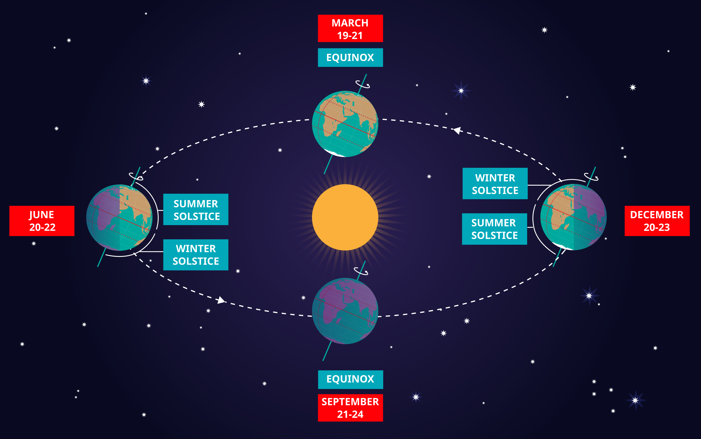
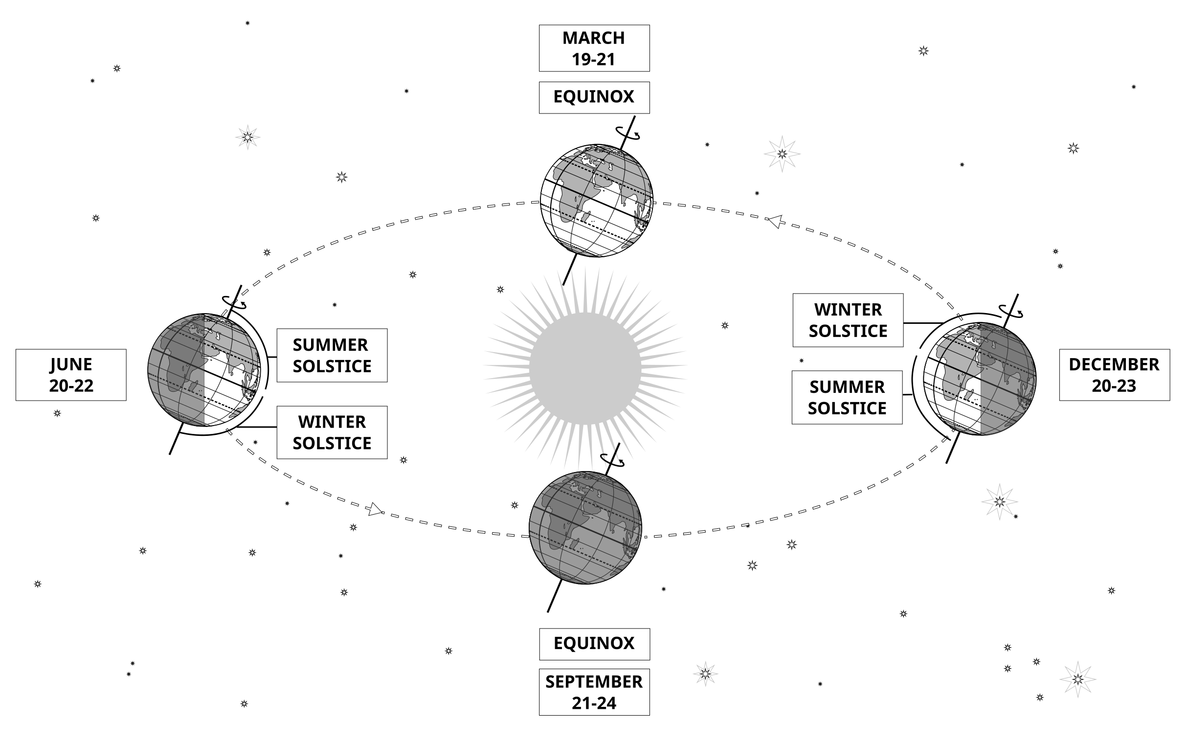
الشرح: This diagram demonstrates the relative positions of the Earth and Sun at the two solstices and two equinoxes. The Earth’s rotation axis is tilted by 23.4° from the axis of its orbit. This means that for half the Earth’s annual orbit around the Sun, the Southern Hemisphere is tilted towards the Sun and the Northern Hemisphere is tilted away from the Sun. During this time the Sun appears to lie below the celestial equator. Due to this at any particular point in the Southern Hemisphere the Sun will appear to be higher above the horizon at a particular time of day and the days will be longer. Conversely during this time, the Sun appears lower in the sky at any particular point in the day in the Northern Hemisphere and the days are shorter.
This effect is most pronounced in late December when the Sun appears at its most southerly point in the sky, corresponding to the longest day of the year in the Southern Hemisphere. This normally occurs on the 21st or 22nd of December (UTC), depending on when the most recent leap year was, but can very occasionally occur on the 20th or 23rd of December. This event is known as the December solstice. As the Sun’s rays hit the Southern Hemisphere at a more perpendicular angle during this time, the Southern Hemisphere is typically warmer in this time of year than at other times of year. This is often referred to as summer in temperate and antarctic regions of the Southern Hemisphere and thus the December solstice is known as the summer solstice. South of the Antarctic Circle at this time the Sun never sets and a Polar Day can last several months. Conversely in the Northern Hemisphere, the Sun’s rays hit the Earth at a more grazing angle than at other times of year so it is colder and this solstice is known as the winter solstice. North of the Arctic Circle the Sun never rises during this time and the Polar Night can last several months.
As the year progresses the Earth moves in its orbit and the tilt of the Earth’s axis moves so it appears more side-on to the Sun. From the perspective of an observer on Earth this means that the Sun moves north in the sky, eventually reaching the celestial equator in late March, This usually occurs on the 20th of March (UTC) but can sometimes occur on the 19th or 21st of March. During this time all places on Earth will experience night and day that is approximately 12 hours long. The Sun’s rays now hit the Southern hemisphere at a more shallow angle than they did in December and hit the Northern Hemisphere at a more perpendicular angle. This means that the Northen Hemisphere will have warmed since December and the Southern Hemisphere cooled. This leads to the March equinox being referred to as the autumn equinox in the Southern Hemisphere and the spring or vernal equinox in the Northern Hemisphere.
As the year progresses further the Sun moves further north on the sky, the Northern Hemisphere days lengthen and the Southern Hemisphere days shorten. By June the Earth’s orbit has progressed to the point where the Northern Hemisphere points towards the Sun and the Southern Hemisphere away from the Sun. At one point between the 20th and 22nd of June (UTC) the Sun reaches its most northerly point in the sky, this is known as June solstice. It is now summer in northern temperate and artic regions so this is known as the summer solstice in the Northern Hemisphere and the winter solstice in the Southern Hemisphere. This is the longest day of the year in the Northern Hemisphere and the shortest day of the year in the Southern Hemisphere. During this time regions north of the Arctic Circle experience a long Polar Day and regions south of the Antarctic Circle experience polar night.
The year progresses further and the Earth moves in its orbit so that the tilt of the Earth’s axis again appears side-on for the Sun. The Sun moves south in the sky and again crosses the celestial equator between the 21st and 24th of September (UTC). At this time all places on the Earth experience equal lengths of day and night. This is known as the September equinox, also called the spring or vernal equinox in the Southern Hemisphere and the autumn equinox in the Northern Hemisphere.
Note the sizes of the Earth, Sun and the Earth’s orbit around the Sun are not to scale in this diagram.
المصدر: Maria Cristina Fortuna/IAU OAE
مصطلحات المعجم:
الاعتدال , خط الاستواء السماوي , الفصول , الانقلاب الشمسي , الانقلاب الصيفي , الانقلاب الشتوي , الاعتدال الربيعي , الاعتدال الخريفي , محور الأرض , الدائرة القطبية الشمالية , الدائرة القطبية الجنوبية , النهار القطبي , الليلة القطبية
فئات:
علم الفلك بالعين المجردة
الترخيص: المشاع الإبداعي نَسب المُصنَّف 4.0 دولي (CC BY 4.0) المشاع الإبداعي نَسب المُصنَّف 4.0 دولي (CC BY 4.0) أيقونات
ملف
( صورة
2.02 MB)
ملف PDF
(PDF file
335.83 kB)
Also available in black and white
ملف
( صورة
485.38 kB)
ملف PDF
(
388.16 kB)
Aquila Constellation Map
صورة
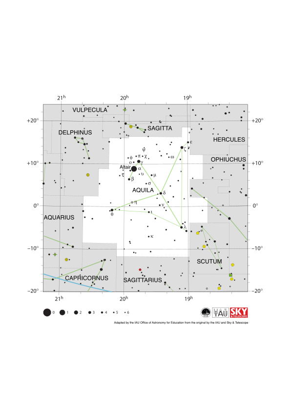
الشرح: The constellation Aquila with its bright stars and surrounding constellations. Aquila is surrounded by (going clockwise from the top): Sagitta, Hercules, Ophiuchus, Serpens Cauda, Scutum, Sagittarius, Capricornus, Aquarius and Delphinus. Aquila is most notable for its brightest star Altair. This forms one vertex of the prominent Summer Triangle asterism that is visible in northern hemisphere summer evenings.
Aquila spans the celestial equator and thus some part of it is visible from all of the Earth at some point in the year. It is most visible in the evenings in the late northern hemisphere summer and late southern hemisphere winter.
The y-axis of this diagram is in degrees of declination with north as up and the x-axis is in hours of right ascension with east to the left. The sizes of the stars marked here relate to the star's apparent magnitude, a measure of its apparent brightness. The larger dots represent brighter stars. The Greek letters mark the brightest stars in the constellation. These are ranked by brightness with the brightest star being labeled alpha, the second brightest beta, etc., although this ordering is not always followed exactly. The dotted boundary lines mark the IAU's boundaries of the constellations and the solid green lines mark one of the common forms used to represent the figures of the constellations. The blue line in the lower right of the diagram is the ecliptic. Neither the constellation boundaries, nor the line marking the ecliptic, nor the lines joining the stars appear on the sky.
المصدر: Adapted by the IAU Office of Astronomy for Education from the original by IAU/Sky & Telescope
رابط المصدر
مصطلحات المعجم:
القدرالظاهري , كوكبة الجدي , الإحداثيات السماوية , خط الاستواء السماوي , مجموعة نجمية او حشد نجمى , الميل , مسار البروج , المطلع المستقيم , الدلو , المجمة
فئات:
علم الفلك بالعين المجردة
الترخيص: المشاع الإبداعي نَسب المُصنَّف 4.0 دولي (CC BY 4.0) المشاع الإبداعي نَسب المُصنَّف 4.0 دولي (CC BY 4.0) أيقونات
ملف
( صورة
95.28 kB)
ملف PDF
(PDF file
175.09 kB)