Dokumente & Ressourchen - Suchergebnisse
Suchergebnisse

Latitude and Longitude
Bild
Erstellt für das OAE
Unterschrift: Two views of the Earth, one viewing the Northern Hemisphere, one viewing the Southern Hemisphere. The Earth rotates around its axis, an imaginary line that runs through the Earth from the North Pole to the South Pole. The Equator is an imaginary line that is the same distant from both the North Pole and the South Pole.
The positions of two cities, Rome in the Northern Hemisphere and Sydney in the Southern Hemisphere are marked here with red dots. Arrows indicate the two spherical coordinates latitude and longitude.
Latitude marks the position north or south of the equator. Here we can see Rome has the letter N in its latitude as it is in the Northern Hemisphere and Sydney has the letter S in its latitude as it is in the Southern Hemisphere. Latitude can vary from 90° N at the North Pole to 0° at the Equator to 90° S at the South Pole.
Longitude measures the position around the equator. While the choice of the zero point for latitude as the equator seems obvious, the choice of the zero point for longitude is more subjective. By convention the zero point in longitude is the prime meridian which passes through the Royal Greenwich Observatory in the UK. This is marked here as a solid line originating at the North Pole. Longitude is measured in degrees east or west of the prime meridian. As both Rome and Sydney lie to the east of Greenwich, they have the letter E as part of their longitude. Moving west to east, longitude varies from 180° W on the other side of the world from the prime meridian to 0° on the prime meridian before reaching 180° E again on the other side of world from the prime meridian.
This diagram shows the Earth at the December solstice. Two views are presented, one viewing the Northern Hemisphere and one viewing the Southern Hemisphere about nine hours later. The shaded region shows the night side of the Earth, with the day side being lighter. As it is the December solstice, the Sun appears overhead at the Tropic of Capricorn. This is a line of constant latitude at 23°26′09.3″ S. Six months later, at the June solstice, the Sun will appear to be overhead at the Tropic of Cancer at 23°26′09.3″ N. As the Sun appears over the Tropic of Capricorn more of the Southern Hemisphere is illuminated than the Northern Hemisphere. Indeed below the Antarctic Circle (the Polar Circle around the South Pole) the Sun does not set at this time of year leading to a Polar Day. Conversely, north of the Arctic Circle (the Polar Circle around the North Pole) the Sun does not rise at this time of year, leading to a Polar Night.
Bild: Maria Cristina Fortuna/IAU OAE
Glossar-Begriffe:
Erdrotation , Äquator , Breitengrad , Längengrad , Polarkreis , Erdachse , Wendekreis , Polartag , Polarnacht , Wendekreis des Krebses , Wendekreis des Steinbocks , Tropen , Nordpol , Südpol
Kategorien:
Astronomie mit bloßem Auge
Lizenz: Creative Commons Namensnennung 4.0 International (CC BY 4.0) Creative Commons Namensnennung 4.0 International (CC BY 4.0) Symbole
Datei
( Bild
434.22 kB)
PDF-Datei
(PDF file
449.61 kB)
Also available in black and white
Datei
( Bild
433.51 kB)
PDF-Datei
(
358.89 kB)

International Date Line
Bild
Erstellt für das OAE
Unterschrift: The International Date Line (shown here as a solid line) is a specific meridian which roughly follows the meridian of longitude 180°. The International Date Line passes north–south between Russia and Alaska, through the Pacific Ocean including parts of Micronesia and Polynesia, and to the east of Australia/New Zealand before reaching the South Pole on Antarctica. The International Date Line marks the boundary where calendar dates change by one. Therefore, regions to the west of the International Date line are one calendar day ahead of regions to the east.
The International Date Line does not always exactly follow the meridian of longitude 180°. This is partly to stop some territory of a country falling on the other side of the International Date Line than the rest of that country (the Aleutian Islands in the United States being a good example). Some countries also choose which side of the International Date Line they lie on. Samoa changed which side of the date line it lay on in 2011. At this point the International Date Line was moved to lie to the east of Samoa having previously passed to the west of Samoa.
On the opposite side of the world the dashed line marks the prime meridian (the meridian of longitude 0°). This is a line that passes through the Royal Greenwich Observatory in the UK. All time zones are measure relative to Universal Time which is the zero point for all timezones. The time zones marked at the top of the diagram are the timezones in the shaded regions excluding the effects of daylight savings time.
Bild: Maria Cristina Fortuna/IAU OAE
Glossar-Begriffe:
Zeitzone , Universalzeit (UT) , Nullmeridian , Datumsgrenze
Kategorien:
Astronomie und Gesellschaft
, Der Planet Erde
Lizenz: Creative Commons Namensnennung 4.0 International (CC BY 4.0) Creative Commons Namensnennung 4.0 International (CC BY 4.0) Symbole
Datei
( Bild
214.47 kB)
PDF-Datei
(PDF file
88.40 kB)
Also available in black and white
Datei
( Bild
272.39 kB)
PDF-Datei
(
88.60 kB)
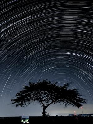
Sternspuren in der südlichen Hemisphäre mit Bortle 4 Skala Lichtverschmutzung
Bild
Erstellt für das OAE
Unterschrift: Dieses atemberaubende Foto, das am 25. Juni 2020 unter dem klaren Nachthimmel des Dorfes Linggamekar, Cilimus, Kuningan, Westjava, Indonesien, aufgenommen wurde, zeigt Sternenspuren, die über den Himmel der südlichen Hemisphäre ziehen. Die Sternspuren sind auf die Erdrotation zurückzuführen, die eine scheinbare Bewegung der Sterne verursacht, wodurch diese faszinierenden Lichtbögen entstehen, wenn sie über längere Zeiträume verfolgt werden. Hier befindet sich der Punkt, um den die Sterne rotieren (der Himmels-Südpol), in der Nähe des Horizonts, da das Bild in der Nähe des Äquators aufgenommen wurde. Der Fotograf nutzte die Sternspur-Funktion seines Smartphones, mit der er eine Reihe von Bildern über einen längeren Zeitraum aufnahm und sie zusammenfügte. Der markante Baum im Vordergrund verleiht dem Bild Tiefe und bildet einen Kontrast zwischen der himmlischen Bewegung über ihm und der irdischen Stille, während er gleichzeitig einen Teil der Lichtverschmutzung in der Umgebung verdeckt. Verschiedene Teile der Welt bieten unterschiedliche und atemberaubende Perspektiven auf den Nachthimmel, was die Relevanz der Erhaltung des dunklen Himmels überall unterstreicht.
Bild: Slamat Riyadi/IAU OAE (CC BY 4.0)
Glossar-Begriffe:
Himmelspol , Himmelskugel , Erdrotation
Kategorien:
Astronomie mit bloßem Auge
Schlagworte
astrophotography
Lizenz: Creative Commons Namensnennung 4.0 International (CC BY 4.0) Creative Commons Namensnennung 4.0 International (CC BY 4.0) Symbole
Diese Datei auf Zenodo ( Bild 5.35 MB)
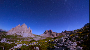
Großer Wagen und Komet Neowise C2020 F3
Video
Erstellt für das OAE
Unterschrift: Dieser Zeitraffer dokumentiert die Flugbahn des ikonischen Großen Wagens in drei Bildern, die im Juli 2020 aufgenommen wurden. Diese visuelle Odyssee wurde von drei Orten in Italien aus aufgenommen: Tre Cime di Lavaredo Auronzo di Cadore, Monte Rite, Cibiana di Cadore und Casera Razzo, Vigo di Cadore. Sie zeigt die fesselnde Reise des Großen Wagens mit zusätzlichen Sternenspuren, die eine himmlische Leinwand zeichnen. Sie verfolgt nicht nur den Weg dieses berühmten Asterismus, sondern zeigt auch das seltene Erscheinen des Kometen Neowise C/2020 F3, ein außergewöhnliches Ereignis, das im Juli 2020 unseren Himmel zierte.
Bild: Giorgia Hofer/IAU OAE (CC BY 4.0)
Glossar-Begriffe:
Großer Wagen , Himmelspol , Himmelskugel , Zirkumpolarsterne , Polarstern , Himmel , Rotation
Kategorien:
Astronomie mit bloßem Auge
Schlagworte
astrophotography
Lizenz: Creative Commons Namensnennung 4.0 International (CC BY 4.0) Creative Commons Namensnennung 4.0 International (CC BY 4.0) Symbole
Diese Datei auf Zenodo ( Video 51.23 MB)
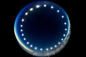
Die Sonnenfinsternis-Uhr – Sonnenfinsternis an einem Polartag
Bild
Erstellt für das OAE
Unterschrift: Das Bild wurde durch die Kombination mehrerer Aufnahmen über einen Zeitraum von 24 Stunden erstellt. Es wurde während der totalen Sonnenfinsternis am 4. Dezember 2021 am Union Gletscher in der Antarktis aufgenommen und zeigt den Tagbogen der Sonne. Es veranschaulicht das einzigartige Phänomen eines Polartages, an dem die Sonne über den Himmel wandert, ohne unterzugehen. An Polartagen herrscht in den Gebieten innerhalb der Polarkreise 24 Stunden lang ununterbrochenes Tageslicht und die Sonne geht über einen längeren Zeitraum nicht unter. Das Bild bietet auch eine seltene Perspektive einer Sonnenfinsternis, bei der der Mond von der Erde aus gesehen zwischen Sonne und Erde vorbeizieht. Die Finsternis ist auf dem untersten Bild der Sonne zu sehen, auf dem der Mond die Sonnenscheibe bedeckt.
Bild: Stephanie Ziyi Ye/IAU OAE (CC BY 4.0)
Glossar-Begriffe:
Sonnenbahn (Tagbogen) , Totale Sonnenfinsternis , Polarkreis
Kategorien:
Astronomie mit bloßem Auge
, Sonnensystem
Schlagworte
astrophotography
Lizenz: Creative Commons Namensnennung 4.0 International (CC BY 4.0) Creative Commons Namensnennung 4.0 International (CC BY 4.0) Symbole
Diese Datei auf Zenodo ( Bild 1.23 MB)