Dokumente & Ressourchen - Suchergebnisse
Suchergebnisse

Seasons
Bild
Erstellt für das OAE
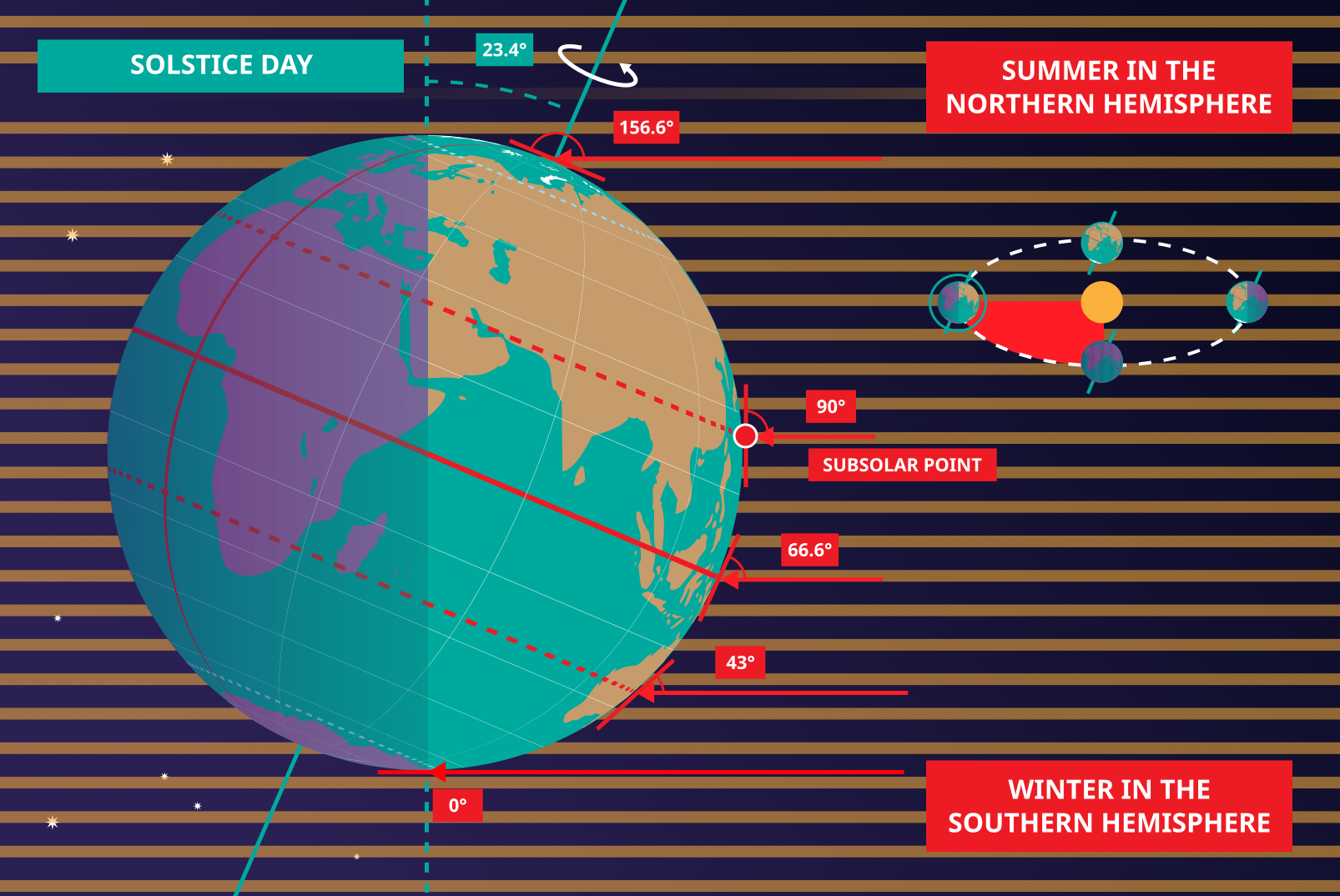
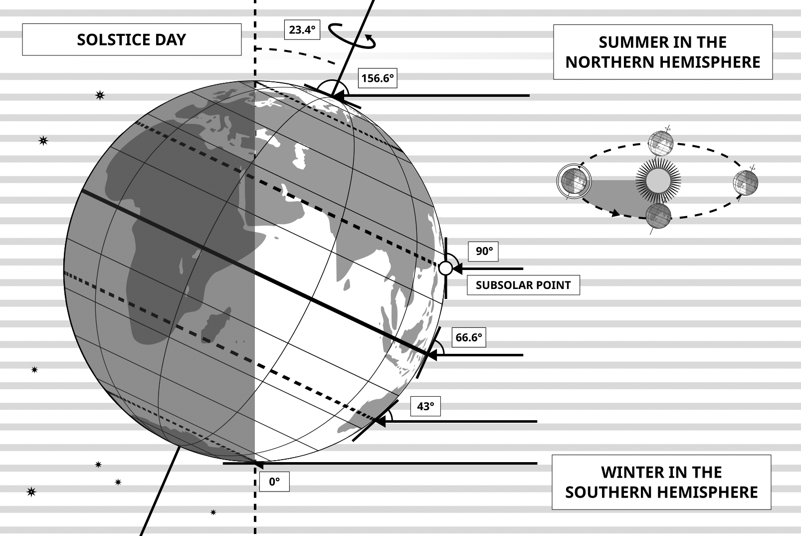
Unterschrift: This diagram shows the Earth at the June solstice which is known as the summer solstice in the Northern Hemisphere and the winter solstice in the Southern Hemisphere. The Earth’s axis of rotation is tilted from the axis of the Earth’s orbit around the Sun by 23.4°. Here we see light from the sun represented as parallel lines, in the diagram the Sun would lie far off the right-hand edge. Five lines are marked with angles. These lines hit the Earth at special latitudes. From top to bottom these lines hit the Earth at the North Pole, the Tropic of Cancer, the Equator, the Tropic of Capricorn and the Antarctic Circle. The lines are shown hitting the Earth at the longitude where it is currently noon. For the last four lines, the angles marked show the angle above the horizon (the altitude) which the Sun appears in the sky at at local noon.
At the June solstice, the Sun will appear directly overhead at local noon on every point on the Tropic of Capricorn. By contrast the Sun reaches a maximum altitude of 0° at local noon on every point in the Antarctic Circle. This means the Sun never rises and every point south of the Antarctic Circle experiences a long Polar Night. By contrast the Sun never sets on this day north of the Arctic Circle and the regions here experience a Polar Day. The at the North Pole the Sun will remain at a constant altitude all day. This altitude will be the angle 180°-156.6° (23.4°).
The altitude the Sun appears at is important as it defines how spread out the Sun’s rays are on the Earth’s surface. Look at the thick, faint parallel lines in the background. Notice how at the Tropic of Cancer the area the lines intersect with the Earth’s surface perpendicularly and the line only covers a small part of the Earth’s surface. Now look at a line near the Tropic of Capricorn and see that this intersects with the Earth at a grazing angle and the line is spread out, covering a much wider area of the Earth’s surface. This means that a given amount of light from the Sun that hits the Tropic of Cancer is more concentrated and the same amount of light hitting the Tropic of Capricorn would be more spread out. This leads to more energy per unit area from the Sun hitting the Tropic of Cancer and less energy per unit area hitting the Tropic of Capricorn. This means it will be warmer at the Tropic of Cancer than at the Tropic of Capricorn. It is thus summer at the Tropic of Cancer and winter at the Tropic of Capricorn.
Six months later this situation will be reversed and it will be summer at the Tropic of Capricorn and winter at the Tropic of Cancer.
Bild: Maria Cristina Fortuna/IAU OAE
Glossar-Begriffe:
Äquator , Sonnenwende , Sommersonnenwende , Winter , Wintersonnenwende , Nördlicher Polarkreis , Südlicher Polarkreis , Wendekreis des Krebses , Wendekreis des Steinbocks , Nordpol
Lizenz: Creative Commons Namensnennung 4.0 International (CC BY 4.0) Creative Commons Namensnennung 4.0 International (CC BY 4.0) Symbole
Datei
( Bild
1.09 MB)
Also available in black and white
Datei
( Bild
400.17 kB)
PDF-Datei
(
477.01 kB)

Solstices and Equinoxes
Bild
Erstellt für das OAE
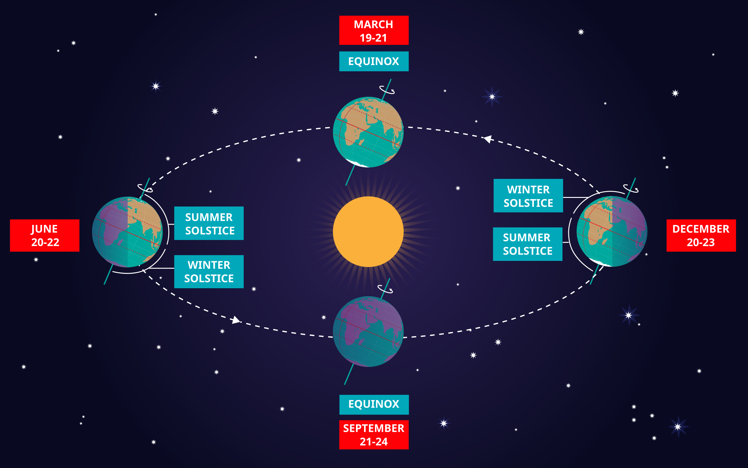
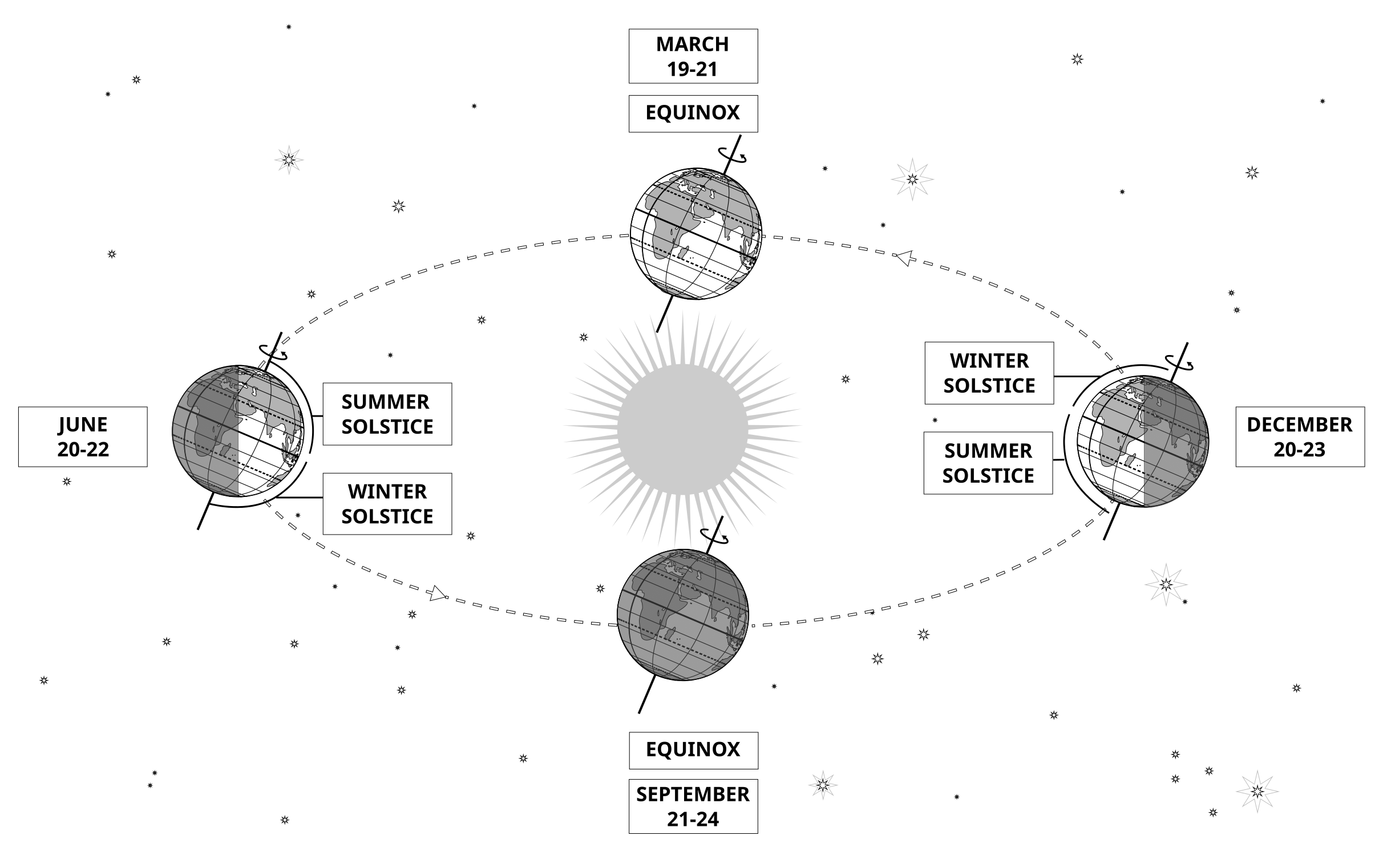
Unterschrift: This diagram demonstrates the relative positions of the Earth and Sun at the two solstices and two equinoxes. The Earth’s rotation axis is tilted by 23.4° from the axis of its orbit. This means that for half the Earth’s annual orbit around the Sun, the Southern Hemisphere is tilted towards the Sun and the Northern Hemisphere is tilted away from the Sun. During this time the Sun appears to lie below the celestial equator. Due to this at any particular point in the Southern Hemisphere the Sun will appear to be higher above the horizon at a particular time of day and the days will be longer. Conversely during this time, the Sun appears lower in the sky at any particular point in the day in the Northern Hemisphere and the days are shorter.
This effect is most pronounced in late December when the Sun appears at its most southerly point in the sky, corresponding to the longest day of the year in the Southern Hemisphere. This normally occurs on the 21st or 22nd of December (UTC), depending on when the most recent leap year was, but can very occasionally occur on the 20th or 23rd of December. This event is known as the December solstice. As the Sun’s rays hit the Southern Hemisphere at a more perpendicular angle during this time, the Southern Hemisphere is typically warmer in this time of year than at other times of year. This is often referred to as summer in temperate and antarctic regions of the Southern Hemisphere and thus the December solstice is known as the summer solstice. South of the Antarctic Circle at this time the Sun never sets and a Polar Day can last several months. Conversely in the Northern Hemisphere, the Sun’s rays hit the Earth at a more grazing angle than at other times of year so it is colder and this solstice is known as the winter solstice. North of the Arctic Circle the Sun never rises during this time and the Polar Night can last several months.
As the year progresses the Earth moves in its orbit and the tilt of the Earth’s axis moves so it appears more side-on to the Sun. From the perspective of an observer on Earth this means that the Sun moves north in the sky, eventually reaching the celestial equator in late March, This usually occurs on the 20th of March (UTC) but can sometimes occur on the 19th or 21st of March. During this time all places on Earth will experience night and day that is approximately 12 hours long. The Sun’s rays now hit the Southern hemisphere at a more shallow angle than they did in December and hit the Northern Hemisphere at a more perpendicular angle. This means that the Northen Hemisphere will have warmed since December and the Southern Hemisphere cooled. This leads to the March equinox being referred to as the autumn equinox in the Southern Hemisphere and the spring or vernal equinox in the Northern Hemisphere.
As the year progresses further the Sun moves further north on the sky, the Northern Hemisphere days lengthen and the Southern Hemisphere days shorten. By June the Earth’s orbit has progressed to the point where the Northern Hemisphere points towards the Sun and the Southern Hemisphere away from the Sun. At one point between the 20th and 22nd of June (UTC) the Sun reaches its most northerly point in the sky, this is known as June solstice. It is now summer in northern temperate and artic regions so this is known as the summer solstice in the Northern Hemisphere and the winter solstice in the Southern Hemisphere. This is the longest day of the year in the Northern Hemisphere and the shortest day of the year in the Southern Hemisphere. During this time regions north of the Arctic Circle experience a long Polar Day and regions south of the Antarctic Circle experience polar night.
The year progresses further and the Earth moves in its orbit so that the tilt of the Earth’s axis again appears side-on for the Sun. The Sun moves south in the sky and again crosses the celestial equator between the 21st and 24th of September (UTC). At this time all places on the Earth experience equal lengths of day and night. This is known as the September equinox, also called the spring or vernal equinox in the Southern Hemisphere and the autumn equinox in the Northern Hemisphere.
Note the sizes of the Earth, Sun and the Earth’s orbit around the Sun are not to scale in this diagram.
Bild: Maria Cristina Fortuna/IAU OAE
Glossar-Begriffe:
Tagundnachtgleiche , Himmelsäquator , Jahreszeiten , Sonnenwende , Sommersonnenwende , Wintersonnenwende , Frühlings-Tagundnachtgleiche , Herbst-Tagundnachtgleiche , Erdachse , Nördlicher Polarkreis , Südlicher Polarkreis , Polartag , Polarnacht
Kategorien:
Astronomie mit bloßem Auge
Lizenz: Creative Commons Namensnennung 4.0 International (CC BY 4.0) Creative Commons Namensnennung 4.0 International (CC BY 4.0) Symbole
Datei
( Bild
2.02 MB)
PDF-Datei
(PDF file
335.83 kB)
Also available in black and white
Datei
( Bild
485.38 kB)
PDF-Datei
(
388.16 kB)

Latitude and Longitude
Bild
Erstellt für das OAE
Unterschrift: Two views of the Earth, one viewing the Northern Hemisphere, one viewing the Southern Hemisphere. The Earth rotates around its axis, an imaginary line that runs through the Earth from the North Pole to the South Pole. The Equator is an imaginary line that is the same distant from both the North Pole and the South Pole.
The positions of two cities, Rome in the Northern Hemisphere and Sydney in the Southern Hemisphere are marked here with red dots. Arrows indicate the two spherical coordinates latitude and longitude.
Latitude marks the position north or south of the equator. Here we can see Rome has the letter N in its latitude as it is in the Northern Hemisphere and Sydney has the letter S in its latitude as it is in the Southern Hemisphere. Latitude can vary from 90° N at the North Pole to 0° at the Equator to 90° S at the South Pole.
Longitude measures the position around the equator. While the choice of the zero point for latitude as the equator seems obvious, the choice of the zero point for longitude is more subjective. By convention the zero point in longitude is the prime meridian which passes through the Royal Greenwich Observatory in the UK. This is marked here as a solid line originating at the North Pole. Longitude is measured in degrees east or west of the prime meridian. As both Rome and Sydney lie to the east of Greenwich, they have the letter E as part of their longitude. Moving west to east, longitude varies from 180° W on the other side of the world from the prime meridian to 0° on the prime meridian before reaching 180° E again on the other side of world from the prime meridian.
This diagram shows the Earth at the December solstice. Two views are presented, one viewing the Northern Hemisphere and one viewing the Southern Hemisphere about nine hours later. The shaded region shows the night side of the Earth, with the day side being lighter. As it is the December solstice, the Sun appears overhead at the Tropic of Capricorn. This is a line of constant latitude at 23°26′09.3″ S. Six months later, at the June solstice, the Sun will appear to be overhead at the Tropic of Cancer at 23°26′09.3″ N. As the Sun appears over the Tropic of Capricorn more of the Southern Hemisphere is illuminated than the Northern Hemisphere. Indeed below the Antarctic Circle (the Polar Circle around the South Pole) the Sun does not set at this time of year leading to a Polar Day. Conversely, north of the Arctic Circle (the Polar Circle around the North Pole) the Sun does not rise at this time of year, leading to a Polar Night.
Bild: Maria Cristina Fortuna/IAU OAE
Glossar-Begriffe:
Erdrotation , Äquator , Breitengrad , Längengrad , Polarkreis , Erdachse , Wendekreis , Polartag , Polarnacht , Wendekreis des Krebses , Wendekreis des Steinbocks , Tropen , Nordpol , Südpol
Kategorien:
Astronomie mit bloßem Auge
Lizenz: Creative Commons Namensnennung 4.0 International (CC BY 4.0) Creative Commons Namensnennung 4.0 International (CC BY 4.0) Symbole
Datei
( Bild
434.22 kB)
PDF-Datei
(PDF file
449.61 kB)
Also available in black and white
Datei
( Bild
433.51 kB)
PDF-Datei
(
358.89 kB)
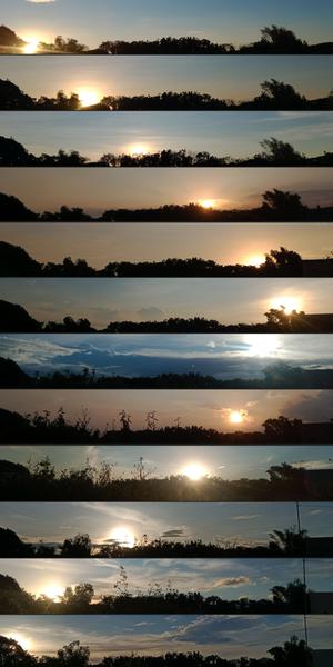
Wo die Sonne jeden Monat untergeht
Bild
Erstellt für das OAE
Unterschrift: Diese Bilderserie wurde mit einem Smartphone in San Rafael in der philippinischen Provinz Bulacan aufgenommen und zeigt die sich im Laufe des Jahres verändernde Position des Sonnenuntergangs bedingt durch die Neigung der Erdachse und die Umlaufbahn der Erde um die Sonne. Jedes dieser von Januar bis Dezember 2022 aufgenommenen Bilder spiegelt die wechselnde Kulisse und Position der Sonne in der Abenddämmerung wider. Achten Sie auf den Laubwechsel und das Erscheinen eines Strommastes im Oktober. Diese Sammlung ist ein visuelles Zeugnis des himmlischen Tanzes zwischen Erde und Sonne und der natürlichen Veränderungen auf der Erde.
Bild: John Paul Pile/IAU OAE (CC BY 4.0)
Glossar-Begriffe:
Tagundnachtgleiche , Sonnenwende , Sommersonnenwende , Sonnenbahn (Tagbogen) , Wintersonnenwende
Kategorien:
Astronomie mit bloßem Auge
Schlagworte
astrophotography
Lizenz: Creative Commons Namensnennung 4.0 International (CC BY 4.0) Creative Commons Namensnennung 4.0 International (CC BY 4.0) Symbole
Diese Datei auf Zenodo ( Bild 11.82 MB)
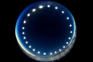
Die Sonnenfinsternis-Uhr – Sonnenfinsternis an einem Polartag
Bild
Erstellt für das OAE
Unterschrift: Das Bild wurde durch die Kombination mehrerer Aufnahmen über einen Zeitraum von 24 Stunden erstellt. Es wurde während der totalen Sonnenfinsternis am 4. Dezember 2021 am Union Gletscher in der Antarktis aufgenommen und zeigt den Tagbogen der Sonne. Es veranschaulicht das einzigartige Phänomen eines Polartages, an dem die Sonne über den Himmel wandert, ohne unterzugehen. An Polartagen herrscht in den Gebieten innerhalb der Polarkreise 24 Stunden lang ununterbrochenes Tageslicht und die Sonne geht über einen längeren Zeitraum nicht unter. Das Bild bietet auch eine seltene Perspektive einer Sonnenfinsternis, bei der der Mond von der Erde aus gesehen zwischen Sonne und Erde vorbeizieht. Die Finsternis ist auf dem untersten Bild der Sonne zu sehen, auf dem der Mond die Sonnenscheibe bedeckt.
Bild: Stephanie Ziyi Ye/IAU OAE (CC BY 4.0)
Glossar-Begriffe:
Sonnenbahn (Tagbogen) , Totale Sonnenfinsternis , Polarkreis
Kategorien:
Astronomie mit bloßem Auge
, Sonnensystem
Schlagworte
astrophotography
Lizenz: Creative Commons Namensnennung 4.0 International (CC BY 4.0) Creative Commons Namensnennung 4.0 International (CC BY 4.0) Symbole
Diese Datei auf Zenodo ( Bild 1.23 MB)