Dokumente & Ressourchen - Suchergebnisse
Suchergebnisse

Latitude and Longitude
Bild
Erstellt für das OAE
Unterschrift: Two views of the Earth, one viewing the Northern Hemisphere, one viewing the Southern Hemisphere. The Earth rotates around its axis, an imaginary line that runs through the Earth from the North Pole to the South Pole. The Equator is an imaginary line that is the same distant from both the North Pole and the South Pole.
The positions of two cities, Rome in the Northern Hemisphere and Sydney in the Southern Hemisphere are marked here with red dots. Arrows indicate the two spherical coordinates latitude and longitude.
Latitude marks the position north or south of the equator. Here we can see Rome has the letter N in its latitude as it is in the Northern Hemisphere and Sydney has the letter S in its latitude as it is in the Southern Hemisphere. Latitude can vary from 90° N at the North Pole to 0° at the Equator to 90° S at the South Pole.
Longitude measures the position around the equator. While the choice of the zero point for latitude as the equator seems obvious, the choice of the zero point for longitude is more subjective. By convention the zero point in longitude is the prime meridian which passes through the Royal Greenwich Observatory in the UK. This is marked here as a solid line originating at the North Pole. Longitude is measured in degrees east or west of the prime meridian. As both Rome and Sydney lie to the east of Greenwich, they have the letter E as part of their longitude. Moving west to east, longitude varies from 180° W on the other side of the world from the prime meridian to 0° on the prime meridian before reaching 180° E again on the other side of world from the prime meridian.
This diagram shows the Earth at the December solstice. Two views are presented, one viewing the Northern Hemisphere and one viewing the Southern Hemisphere about nine hours later. The shaded region shows the night side of the Earth, with the day side being lighter. As it is the December solstice, the Sun appears overhead at the Tropic of Capricorn. This is a line of constant latitude at 23°26′09.3″ S. Six months later, at the June solstice, the Sun will appear to be overhead at the Tropic of Cancer at 23°26′09.3″ N. As the Sun appears over the Tropic of Capricorn more of the Southern Hemisphere is illuminated than the Northern Hemisphere. Indeed below the Antarctic Circle (the Polar Circle around the South Pole) the Sun does not set at this time of year leading to a Polar Day. Conversely, north of the Arctic Circle (the Polar Circle around the North Pole) the Sun does not rise at this time of year, leading to a Polar Night.
Bild: Maria Cristina Fortuna/IAU OAE
Glossar-Begriffe:
Erdrotation , Äquator , Breitengrad , Längengrad , Polarkreis , Erdachse , Wendekreis , Polartag , Polarnacht , Wendekreis des Krebses , Wendekreis des Steinbocks , Tropen , Nordpol , Südpol
Kategorien:
Astronomie mit bloßem Auge
, Der Planet Erde
Lizenz: Creative Commons Namensnennung 4.0 International (CC BY 4.0) Creative Commons Namensnennung 4.0 International (CC BY 4.0) Symbole
Datei
( Bild
434.22 kB)
PDF-Datei
(PDF file
449.61 kB)
Also available in black and white
Datei
( Bild
433.51 kB)
PDF-Datei
(
358.89 kB)

Waage-Sternbildkarte
Bild
Unterschrift: Das Sternbild Waage mit seinen hellen Sternen und den umliegenden Sternbildern. Die Waage ist im Uhrzeigersinn von oben gehend umgeben von dem Kopf der Schlange, Jungfrau, Wasserschlange, Zentaur, Wolf, Skorpion und Schlangenträger. Die Waage liegt auf der Ekliptik (hier als blaue Linie dargestellt), das ist der Weg, den die Sonne im Laufe eines Jahres über den Himmel zu nehmen scheint. Die Sonne befindet sich von Ende Oktober bis Ende November in der Waage. Die anderen Planeten des Sonnensystems sind oft in der Waage zu finden.
Die Waage liegt knapp südlich des Himmelsäquators und ist daher in allen Regionen mit Ausnahme der arktischsten im Laufe des Jahres irgendwann einmal sichtbar. Am besten zu sehen ist die Waage abends auf der Nordhalbkugel im späten Frühling/Frühsommer und auf der Südhalbkugel im Spätherbst/Frühwinter.
Die y-Achse dieses Diagramms ist in Deklinationsgraden mit Norden nach oben und die x-Achse in Stunden der Rektaszension mit Osten nach links. Die Größe der hier markierten Sterne bezieht sich auf die scheinbare Helligkeit des Sterns. Je größer die Punkte, desto heller scheinen die Sterne die sie darstellen. Die griechischen Buchstaben kennzeichnen die hellsten Sterne des Sternbildes. Diese sind nach Helligkeit geordnet, wobei der hellste Stern mit Alpha, der zweithellste mit Beta usw. bezeichnet wird, obwohl diese Reihenfolge nicht immer genau eingehalten wird. Die gepunkteten Begrenzungslinien markieren die IAU-Grenzen der Sternbilder und die durchgezogenen grünen Linien markieren eine der üblichen Formen, die zur Darstellung der Sternbilder verwendet werden. Weder die Sternbildgrenzen, noch die Linie, die die Ekliptik markiert, noch die Linien, die die Sterne verbinden, sind am Himmel sichtbar.
Bild: Angepasst vom IAU Office of Astronomy for Education nach dem Original von IAU/Sky & Telescope
Link zur Quelle
Glossar-Begriffe:
Scheinbare Helligkeit , Himmelskoordinaten , Sternbild , Deklination , Ekliptik , Waage , Rektaszension (RA) , Skorpion , Tierkreis , Jungfrau
Kategorien:
Astronomie mit bloßem Auge
Lizenz: Creative Commons Namensnennung 4.0 International (CC BY 4.0) Creative Commons Namensnennung 4.0 International (CC BY 4.0) Symbole
Datei
( Bild
104.23 kB)
PDF-Datei
(PDF file
196.85 kB)
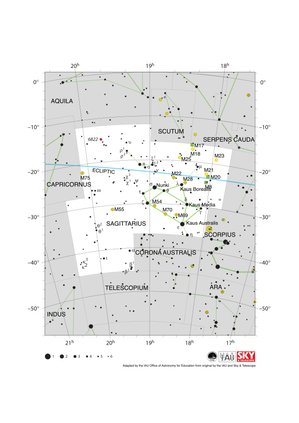
Sagittarius Constellation Map
Bild
Unterschrift: The constellation Sagittarius along with its bright stars and surrounding constellations. Sagittarius is surrounded by (going clockwise from the top) Aquila, Scutum, Serpens Cauda, Ophiuchus, Scorpius, Corona Australis, Telescopium, Microscopium and Capricornus. The brighter stars in Sagittarius form a distinctive teapot shape. Sagittarius lies on the ecliptic (shown here as a blue line), this is the path the Sun appears to take across the sky over the course of a year. The Sun is in Sagittarius from mid December to mid January. The other planets of the Solar System can often be found in Sagittarius.
Sagittarius lies south of the celestial equator. The famous teapot asterism is visible for all but the most arctic regions of the world but the most southerly parts of the constellation are not visible in northern parts of Asia, Europe and North America. Sagittarius is most visible in the evenings in the northern hemisphere summer and southern hemisphere winter.
The supermassive black hole Sagittarius A* which lies at the center of our Milky Way Galaxy is sits on the western (here right-hand) edge of Sagittarius. Due to it covering an area at the center of our Galaxy, Sagittarius is home to many star clusters including open clusters (marked here with yellow circles) and globular clusters (marked here with yellow circles with + signs superimposed on them). Three nebulae are also marked here with green squares.
The y-axis of this diagram is in degrees of declination with north as up and the x-axis is in hours of right ascension with east to the left. The sizes of the stars marked here relate to the star's apparent magnitude, a measure of its apparent brightness. The larger dots represent brighter stars. The Greek letters mark the brightest stars in the constellation. These are ranked by brightness with the brightest star being labeled alpha, the second brightest beta, etc., although this ordering is not always followed exactly. The dotted boundary lines mark the IAU's boundaries of the constellations and the solid green lines mark one of the common forms used to represent the figures of the constellations. Neither the constellation boundaries, nor the line marking the ecliptic, nor the lines joining the stars appear on the sky.
Bild: Adapted by the IAU Office of Astronomy for Education from the original by IAU/Sky & Telescope
Link zur Quelle
Glossar-Begriffe:
Scheinbare Helligkeit , Steinbock , Himmelskoordinaten , Sternbild , Deklination , Ekliptik , Kugelsternhaufen , Milchstraße , Nebel , Rektaszension (RA) , Sagittarius A* , Skorpion , Supermassereiches Schwarzes Loch , Tierkreis , Asterismus , Offener Sternhaufen , Schütze
Kategorien:
Astronomie mit bloßem Auge
Lizenz: Creative Commons Namensnennung 4.0 International (CC BY 4.0) Creative Commons Namensnennung 4.0 International (CC BY 4.0) Symbole
Datei
( Bild
150.62 kB)
PDF-Datei
(PDF file
219.78 kB)
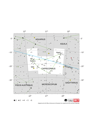
Capricornus Constellation Map
Bild
Unterschrift: The constellation Capricornus (commonly called Capricorn) including its bright stars and surrounding constellations. Capricornus is surrounded by (going clockwise from the top) Aquarius, Aquila, Sagittarius, Microscopium and Piscis Austrinus. Capricornus lies on the ecliptic (shown here as a blue line), this is the path the Sun appears to take across the sky over the course of a year. The Sun is in Capricornus from mid January to mid February. The other planets of the Solar System can often be found in Capricornus.
Capricornus lies just south of the celestial equator and is visible to all observers south of the Arctic Circle. Capricornus is most visible in the evenings in the northern hemisphere autumn and southern hemisphere spring.
In the south east (lower left on this diagram) of the constellation one can find the globular cluster M30 (shown here as a yellow circle with a plus sign superimposed on it).
The y-axis of this diagram is in degrees of declination with north as up and the x-axis is in hours of right ascension with east to the left. The sizes of the stars marked here relate to the star's apparent magnitude, a measure of its apparent brightness. The larger dots represent brighter stars. The Greek letters mark the brightest stars in the constellation. These are ranked by brightness with the brightest star being labeled alpha, the second brightest beta, etc., although this ordering is not always followed exactly. The dotted boundary lines mark the IAU's boundaries of the constellations and the solid green lines mark one of the common forms used to represent the figures of the constellations. Neither the constellation boundaries, nor the line marking the ecliptic, nor the lines joining the stars appear on the sky.
Bild: Adapted by the IAU Office of Astronomy for Education from the original by IAU/Sky & Telescope
Link zur Quelle
Glossar-Begriffe:
Scheinbare Helligkeit , Steinbock , Himmelskoordinaten , Sternbild , Deklination , Ekliptik , Kugelsternhaufen , Rektaszension (RA) , Tierkreis , Wassermann , Schütze , Wendekreis des Steinbocks
Kategorien:
Astronomie mit bloßem Auge
Lizenz: Creative Commons Namensnennung 4.0 International (CC BY 4.0) Creative Commons Namensnennung 4.0 International (CC BY 4.0) Symbole
Datei
( Bild
97.98 kB)
PDF-Datei
(PDF file
180.85 kB)
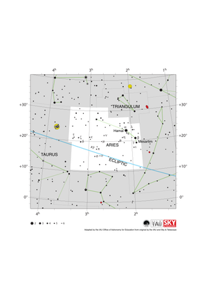
Aries Constellation Map
Bild
Unterschrift: The constellation Aries along with its bright stars and surrounding constellations. Aries is surrounded by (going clockwise from the top) Triangulum, Pisces, Cetus, Taurus and Perseus. Aries lies on the ecliptic (shown here as a blue line), this is the path the Sun appears to take across the sky over the course of a year. The Sun is in Aries from mid April to mid May. The other planets of the Solar System can often be found in Aries.
Aries lies just north of the celestial equator and is thus visible at some time in the year from all of planet Earth except for the most antarctic regions of the world. Aries is most visible in the evenings in the northern hemisphere winter and southern hemisphere summer.
The y-axis of this diagram is in degrees of declination with north as up and the x-axis is in hours of right ascension with east to the left. The sizes of the stars marked here relate to the star's apparent magnitude, a measure of its apparent brightness. The larger dots represent brighter stars. The Greek letters mark the brightest stars in the constellation. These are ranked by brightness with the brightest star being labeled alpha, the second brightest beta, etc., although this ordering is not always followed exactly. The dotted boundary lines mark the IAU's boundaries of the constellations and the solid green lines mark one of the common forms used to represent the figures of the constellations. Neither the constellation boundaries, nor the line marking the ecliptic, nor the lines joining the stars appear on the sky.
Bild: Adapted by the IAU Office of Astronomy for Education from the original by IAU/Sky & Telescope
Link zur Quelle
Glossar-Begriffe:
Scheinbare Helligkeit , Widder , Himmelskoordinaten , Sternbild , Deklination , Ekliptik , Fische , Rektaszension (RA) , Stier , Tierkreis
Kategorien:
Astronomie mit bloßem Auge
Lizenz: Creative Commons Namensnennung 4.0 International (CC BY 4.0) Creative Commons Namensnennung 4.0 International (CC BY 4.0) Symbole
Datei
( Bild
96.59 kB)
PDF-Datei
(PDF file
178.36 kB)