Dokumente & Ressourchen - Suchergebnisse
Suchergebnisse

Seasons
Bild
Erstellt für das OAE
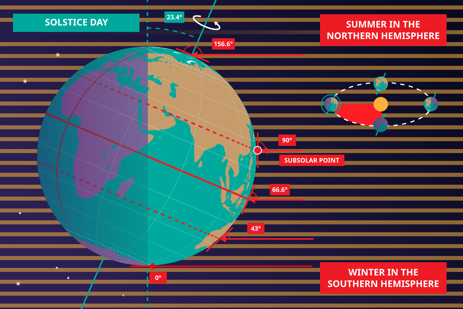
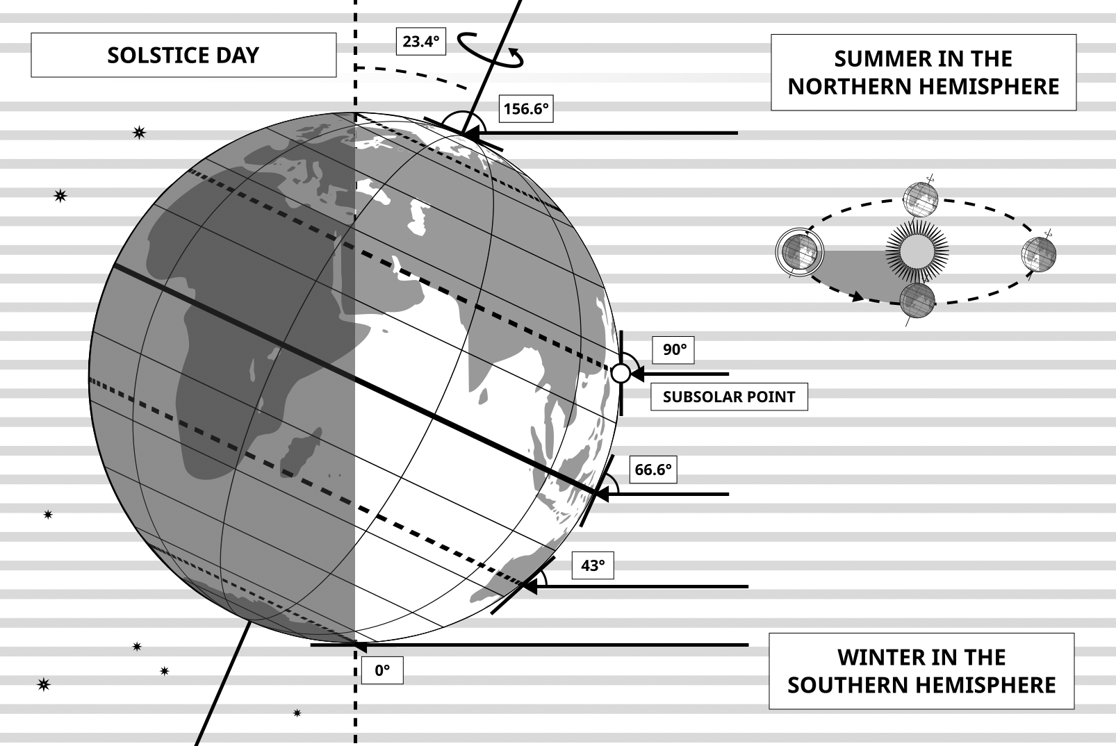
Unterschrift: This diagram shows the Earth at the June solstice which is known as the summer solstice in the Northern Hemisphere and the winter solstice in the Southern Hemisphere. The Earth’s axis of rotation is tilted from the axis of the Earth’s orbit around the Sun by 23.4°. Here we see light from the sun represented as parallel lines, in the diagram the Sun would lie far off the right-hand edge. Five lines are marked with angles. These lines hit the Earth at special latitudes. From top to bottom these lines hit the Earth at the North Pole, the Tropic of Cancer, the Equator, the Tropic of Capricorn and the Antarctic Circle. The lines are shown hitting the Earth at the longitude where it is currently noon. For the last four lines, the angles marked show the angle above the horizon (the altitude) which the Sun appears in the sky at at local noon.
At the June solstice, the Sun will appear directly overhead at local noon on every point on the Tropic of Capricorn. By contrast the Sun reaches a maximum altitude of 0° at local noon on every point in the Antarctic Circle. This means the Sun never rises and every point south of the Antarctic Circle experiences a long Polar Night. By contrast the Sun never sets on this day north of the Arctic Circle and the regions here experience a Polar Day. The at the North Pole the Sun will remain at a constant altitude all day. This altitude will be the angle 180°-156.6° (23.4°).
The altitude the Sun appears at is important as it defines how spread out the Sun’s rays are on the Earth’s surface. Look at the thick, faint parallel lines in the background. Notice how at the Tropic of Cancer the area the lines intersect with the Earth’s surface perpendicularly and the line only covers a small part of the Earth’s surface. Now look at a line near the Tropic of Capricorn and see that this intersects with the Earth at a grazing angle and the line is spread out, covering a much wider area of the Earth’s surface. This means that a given amount of light from the Sun that hits the Tropic of Cancer is more concentrated and the same amount of light hitting the Tropic of Capricorn would be more spread out. This leads to more energy per unit area from the Sun hitting the Tropic of Cancer and less energy per unit area hitting the Tropic of Capricorn. This means it will be warmer at the Tropic of Cancer than at the Tropic of Capricorn. It is thus summer at the Tropic of Cancer and winter at the Tropic of Capricorn.
Six months later this situation will be reversed and it will be summer at the Tropic of Capricorn and winter at the Tropic of Cancer.
Bild: Maria Cristina Fortuna/IAU OAE
Glossar-Begriffe:
Äquator , Sonnenwende , Sommersonnenwende , Winter , Wintersonnenwende , Nördlicher Polarkreis , Südlicher Polarkreis , Wendekreis des Krebses , Wendekreis des Steinbocks , Nordpol
Lizenz: Creative Commons Namensnennung 4.0 International (CC BY 4.0) Creative Commons Namensnennung 4.0 International (CC BY 4.0) Symbole
Datei
( Bild
1.09 MB)
Also available in black and white
Datei
( Bild
400.17 kB)
PDF-Datei
(
477.01 kB)