Documents & Ressources - Résultat de la recherche
Résultats de la recherche
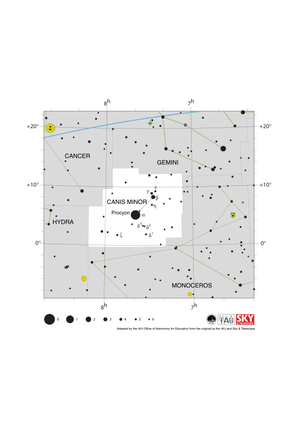
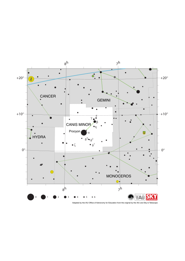
Canis Minor Constellation Map
image
Légende : The constellation Canis Minor with its bright stars and surrounding constellations. Canis Minor is surrounded by (going clockwise from the top): Gemini, Monoceros, Hydra and Cancer. Canis Minor has relatively few bright stars but its brightest star Procyon is the eight brightest star in the sky.
Canis Minor spans the celestial equator and thus part of the constellation is visible from the whole Earth at some point during the year. The whole constellation is visible to all but the most arctic and antarctic regions.
The y-axis of this diagram is in degrees of declination with north as up and the x-axis is in hours of right ascension with east to the left. The sizes of the stars marked here relate to the star's apparent magnitude, a measure of its apparent brightness. The larger dots represent brighter stars. The Greek letters mark the brightest stars in the constellation. These are ranked by brightness with the brightest star being labeled alpha, the second brightest beta, etc., although this ordering is not always followed exactly. The dotted boundary lines mark the IAU's boundaries of the constellations and the solid green lines mark one of the common forms used to represent the figures of the constellations. The blue line in the top right of the diagram marks the ecliptic. Neither the constellation boundaries, nor the line marking the ecliptic, nor the lines joining the stars appear on the sky.
Crédit : Adapted by the IAU Office of Astronomy for Education from the original by the IAU and Sky & Telescope
Lien du crédit
Termes du glossaire:
Magnitude apparente , Coordonnées célestes , Équateur céleste , Constellation , Déclinaison , Ecliptique , Ascension droite (AD)
Catégories :
Astronomie à l'œil nu
Licence : Creative Commons (CC) Attribution 4.0 International (CC BY 4.0) Creative Commons (CC) Attribution 4.0 International (CC BY 4.0) Icônes
Fichier
( image
76.24 kB)
Fichier PDF
(PDF file
153.55 kB)
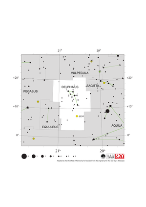
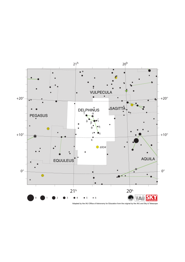
Delphinus Constellation Map
image
Légende : The constellation Delphinus with its brighter stars and surrounding constellations. Delphinus is surrounded by (going clockwise from the top): Vulpecula, Sagitta, Aquila, Aquarius, Equuleus and Pegasus. Delphinus is a relatively small constellation with few bright stars.
Delphinus lies just north of the celestial equator and thus the whole constellation is visible at some point in the year to all but the most antarctic regions. The constellation is best viewed in the evenings in the early northern hemisphere autumn and early southern hemisphere spring.
The globular cluster NGC 6934 lies in Dephinus. It is marked here with a yellow circle with a plus sign superimposed on it.
The y-axis of this diagram is in degrees of declination with north as up and the x-axis is in hours of right ascension with east to the left. The sizes of the stars marked here relate to the star's apparent magnitude, a measure of its apparent brightness. The larger dots represent brighter stars. The Greek letters mark the brightest stars in the constellation. These are ranked by brightness with the brightest star being labeled alpha, the second brightest beta, etc., although this ordering is not always followed exactly. The dotted boundary lines mark the IAU's boundaries of the constellations and the solid green lines mark one of the common forms used to represent the figures of the constellations. Neither the constellation boundaries, nor the lines joining the stars appear on the sky.
Crédit : Adapted by the IAU Office of Astronomy for Education from the original by the IAU and Sky & Telescope
Lien du crédit
Termes du glossaire:
Magnitude apparente , Coordonnées célestes , Équateur céleste , Constellation , Déclinaison , Amas globulaire , Ascension droite (AD) , Verseau
Catégories :
Astronomie à l'œil nu
Licence : Creative Commons (CC) Attribution 4.0 International (CC BY 4.0) Creative Commons (CC) Attribution 4.0 International (CC BY 4.0) Icônes
Fichier
( image
70.98 kB)
Fichier PDF
(PDF file
147.37 kB)

Latitude and Longitude
image
Créé pour l'OAE
Légende : Two views of the Earth, one viewing the Northern Hemisphere, one viewing the Southern Hemisphere. The Earth rotates around its axis, an imaginary line that runs through the Earth from the North Pole to the South Pole. The Equator is an imaginary line that is the same distant from both the North Pole and the South Pole.
The positions of two cities, Rome in the Northern Hemisphere and Sydney in the Southern Hemisphere are marked here with red dots. Arrows indicate the two spherical coordinates latitude and longitude.
Latitude marks the position north or south of the equator. Here we can see Rome has the letter N in its latitude as it is in the Northern Hemisphere and Sydney has the letter S in its latitude as it is in the Southern Hemisphere. Latitude can vary from 90° N at the North Pole to 0° at the Equator to 90° S at the South Pole.
Longitude measures the position around the equator. While the choice of the zero point for latitude as the equator seems obvious, the choice of the zero point for longitude is more subjective. By convention the zero point in longitude is the prime meridian which passes through the Royal Greenwich Observatory in the UK. This is marked here as a solid line originating at the North Pole. Longitude is measured in degrees east or west of the prime meridian. As both Rome and Sydney lie to the east of Greenwich, they have the letter E as part of their longitude. Moving west to east, longitude varies from 180° W on the other side of the world from the prime meridian to 0° on the prime meridian before reaching 180° E again on the other side of world from the prime meridian.
This diagram shows the Earth at the December solstice. Two views are presented, one viewing the Northern Hemisphere and one viewing the Southern Hemisphere about nine hours later. The shaded region shows the night side of the Earth, with the day side being lighter. As it is the December solstice, the Sun appears overhead at the Tropic of Capricorn. This is a line of constant latitude at 23°26′09.3″ S. Six months later, at the June solstice, the Sun will appear to be overhead at the Tropic of Cancer at 23°26′09.3″ N. As the Sun appears over the Tropic of Capricorn more of the Southern Hemisphere is illuminated than the Northern Hemisphere. Indeed below the Antarctic Circle (the Polar Circle around the South Pole) the Sun does not set at this time of year leading to a Polar Day. Conversely, north of the Arctic Circle (the Polar Circle around the North Pole) the Sun does not rise at this time of year, leading to a Polar Night.
Crédit : Maria Cristina Fortuna/IAU OAE
Termes du glossaire:
La rotation de la Terre , Équateur , Latitude , Longitude , Cercle polaire , Axe de la Terre , Tropique , Journée polaire , Nuit polaire , Tropique du Cancer , Tropique du Capricorne , Tropiques , Pôle Nord , Pôle Sud
Catégories :
Astronomie à l'œil nu
Licence : Creative Commons (CC) Attribution 4.0 International (CC BY 4.0) Creative Commons (CC) Attribution 4.0 International (CC BY 4.0) Icônes
Fichier
( image
434.22 kB)
Fichier PDF
(PDF file
449.61 kB)
Also available in black and white
Fichier
( image
433.51 kB)
Fichier PDF
(
358.89 kB)

Indus Constellation Map
image
Légende : The constellation Indus with its bright stars and surrounding constellations. Indus is surrounded by (going clockwise from the top): Microcopium, Sagittarius, Telescopium, Pavo, Octans, Tucana and Grus.
Indus lies near the south celestial pole and thus the whole constellation is visible at some point in the year throughout the southern hemisphere. The whole constellation is also visible to a thin strip of the northern hemisphere near the equator with remaining northern equatorial regions able to see parts of the constellation. Indus is circumpolar for temperate and antarctic regions of the southern hemisphere. Indus is best viewed in the evenings in the northern hemisphere autumn and southern hemisphere spring.
The y-axis of this diagram is in degrees of declination with north as up and the x-axis is in hours of right ascension with east to the left. The sizes of the stars marked here relate to the star's apparent magnitude, a measure of its apparent brightness. The larger dots represent brighter stars. The Greek letters mark the brightest stars in the constellation. These are ranked by brightness with the brightest star being labeled alpha, the second brightest beta, etc., although this ordering is not always followed exactly. The dotted boundary lines mark the IAU's boundaries of the constellations and the solid green lines mark one of the common forms used to represent the figures of the constellations. Neither the constellation boundaries, nor the lines joining the stars appear on the sky.
Crédit : Adapted by the IAU Office of Astronomy for Education from the original by the IAU and Sky & Telescope
Lien du crédit
Termes du glossaire:
Magnitude apparente , Coordonnées célestes , Étoiles circumpolaires , Constellation , Déclinaison , Ascension droite (AD)
Catégories :
Astronomie à l'œil nu
Licence : Creative Commons (CC) Attribution 4.0 International (CC BY 4.0) Creative Commons (CC) Attribution 4.0 International (CC BY 4.0) Icônes
Fichier
( image
114.76 kB)
Fichier PDF
(PDF file
175.05 kB)

Sextans Constellation Map
image
Légende : The constellation Sextans with its brighter stars and surrounding constellations. Sextans is surrounded by (going clockwise from the top): Leo, Hydra and Crater. Sextans is a small constellation with relatively few bright stars.
Sextans spans the celestial equator and thus parts of the constellation are visible at some point in the year across the Earth. The whole constellation is visible in all but the most arctic and most antarctic regions. Sextans is best viewed in the evening in the northern hemisphere spring and southern hemisphere autumn.
The lenticular galaxy NGC 3115 lies in Sextans. It is marked here with a red ellipse.
The y-axis of this diagram is in degrees of declination with north as up and the x-axis is in hours of right ascension with east to the left. The sizes of the stars marked here relate to the star's apparent magnitude, a measure of its apparent brightness. The larger dots represent brighter stars. The Greek letters mark the brightest stars in the constellation. These are ranked by brightness with the brightest star being labeled alpha, the second brightest beta, etc., although this ordering is not always followed exactly. The dotted boundary lines mark the IAU's boundaries of the constellations and the solid green lines mark one of the common forms used to represent the figures of the constellations. The blue line at the top of the diagram marks the ecliptic. Neither the constellation boundaries, nor the lines joining the stars, nor the ecliptic, appear on the sky.
Crédit : Adapted by the IAU Office of Astronomy for Education from the original by the IAU and Sky & Telescope
Lien du crédit
Termes du glossaire:
Magnitude apparente , Coordonnées célestes , Équateur céleste , Constellation , Déclinaison , Ecliptique , Leo , Ascension droite (AD) , Galaxie lenticulaire
Catégories :
Astronomie à l'œil nu
Licence : Creative Commons (CC) Attribution 4.0 International (CC BY 4.0) Creative Commons (CC) Attribution 4.0 International (CC BY 4.0) Icônes
Fichier
( image
73.40 kB)
Fichier PDF
(PDF file
153.02 kB)





- Ressources
- Moteur de recherche des ressources pédagogiques
- Parcourir les ressources pédagogiques par Sujet
- Parcourir les images
- AstroEdu - Activités en classe
- Grandes Idées - Littéracie en astronomie
- Glossaire
- Rapports de l'OAE
- L'astronomie pour l'Education à travers le monde
- Sélection de ressources externes