Documents & Resources - Search Results
Search results

Celestial Coordinates
image
Created for the OAE
Caption: Here we see how celestial coordinates map positions on the celestial sphere. The celestial sphere is an imaginary, hollow sphere that surrounds the Earth. Celestial objects appear to be attached to the inside of the celestial sphere, and the planets, Sun, and Moon appear to move slowly across it.
The celestial sphere has a spherical coordinate system similar to the latitude and longitude we see on the Earth. The celestial equator is the projection of the Earth's equator onto the celestial sphere while the north and south celestial poles are the projections of the Earth's north and south poles onto the celestial sphere.
Declination is similar to latitude on the Earth in that it marks the angle above and below the celestial equator. Declination is zero on the celestial equator, is positive to the north of the celestial equator and negative to the south of it. It is commonly measured in degrees and sometimes in radians.
Right Ascension is similar to longitude as it marks the angle around the celestial equator. As with longitude the zero point of right ascension (shown here as a dashed line) is a matter of choice. Traditionally the zero point of right ascension was the position of the Sun at the northern hemisphere vernal equinox (spring equinox) in March. It is positive and increases to the east, unlike longitude on Earth which is defined as east or west of the prime meridian. It is most commonly measured in hours, minutes and seconds or occasionally in degrees or radians.
The ecliptic marks the Sun's path across the celestial sphere when viewed from the Earth.
The Earth rotates within the celestial sphere. This leads to objects like stars or galaxies, which appear static on the celestial sphere, rising and setting when viewed from the Earth but remaining in the same position on the celestial sphere.
The Earth's axis precesses within the celestial sphere. This slowly moves the celestial equator and the celestial poles meaning that the traditional celestial coordinate system changes slowly over time meaning that stars and galaxies that do not move will have positions that change. Astronomers have used coordinate systems defined by the position of the celestial poles and equator at a fixed point in time. Now celestial positions are most commonly measured on a fixed coordinate system defined by the position of the celestial poles and equator on the 1st of January 2000.
Credit: Maria Cristina Fortuna/IAU OAE
Categories:
Naked Eye Astronomy
, Observational Astronomy
License: Creative Commons Attribution 4.0 International (CC BY 4.0) Creative Commons Attribution 4.0 International (CC BY 4.0) icons
File
( image
517.83 kB)
PDF File
(PDF file
203.59 kB)
Also available in black and white
File
( image
501.79 kB)
PDF File
(
202.13 kB)

Lupus Constellation Map
image
Caption: The constellation Lupus with its bright stars and surrounding constellations. Lupus is surrounded by (going clockwise from the top): Libra, Hydra, Centaurus, Circinus, Norma and Scorpius.
Lupus is a southern constellation and thus the whole constellation is visible at some point in the year throughout the southern hemisphere. The whole constellation is visible in equatorial and some temperate regions of the northern hemisphere with parts of the constellation visible to remaining temperate regions. Lupus is best viewed in the evenings in the northern hemisphere summer and southern hemisphere winter.
The y-axis of this diagram is in degrees of declination with north as up and the x-axis is in hours of right ascension with east to the left. The sizes of the stars marked here relate to the star's apparent magnitude, a measure of its apparent brightness. The larger dots represent brighter stars. The Greek letters mark the brightest stars in the constellation. These are ranked by brightness with the brightest star being labeled alpha, the second brightest beta, etc., although this ordering is not always followed exactly. The dotted boundary lines mark the IAU's boundaries of the constellations and the solid green lines mark one of the common forms used to represent the figures of the constellations. The blue line in the top left of the diagram marks the ecliptic. Neither the constellation boundaries, nor the line marking the ecliptic, nor the lines joining the stars appear on the sky.
Credit: Adapted by the IAU Office of Astronomy for Education from the original by the IAU and Sky & Telescope
Credit Link
Glossary Terms:
Apparent Magnitude , Celestial Coordinates , Constellation , Declination , Ecliptic , Libra , Right Ascension (RA) , Scorpius
Categories:
Naked Eye Astronomy
License: Creative Commons Attribution 4.0 International (CC BY 4.0) Creative Commons Attribution 4.0 International (CC BY 4.0) icons
File
( image
126.11 kB)
PDF File
(PDF file
197.33 kB)
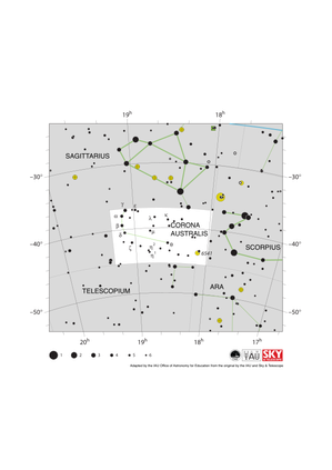
Corona Australis Constellation Map
image
Caption: The constellation Corona Australis with its brighter stars and surrounding constellations. Corona Australis is surrounded by (going clockwise from the top): Sagittarius, Scorpius, Ara and Telescopium. This constellation has relatively few bright stars.
Corona Australis is a southern constellation and thus the whole constellation is visible in the southern hemisphere at some point in the year. The constellation can also be viewed from equatorial and some temperate regions of the northern hemisphere. The constellation is best viewed in the evening in the northern hemisphere summer and southern hemisphere winter.
The globular cluster NGC 6541 lies in Corona Australis and is marked here with a yellow circle with a plus sign superimposed on it.
The y-axis of this diagram is in degrees of declination with north as up and the x-axis is in hours of right ascension with east to the left. The sizes of the stars marked here relate to the star's apparent magnitude, a measure of its apparent brightness. The larger dots represent brighter stars. The Greek letters mark the brightest stars in the constellation. These are ranked by brightness with the brightest star being labeled alpha, the second brightest beta, etc., although this ordering is not always followed exactly. The dotted boundary lines mark the IAU's boundaries of the constellations and the solid green lines mark one of the common forms used to represent the figures of the constellations. Neither the constellation boundaries, nor the lines joining the stars appear on the sky. The blue line at the top right of the diagram marks the ecliptic.
Credit: Adapted by the IAU Office of Astronomy for Education from the original by the IAU and Sky & Telescope
Credit Link
Glossary Terms:
Apparent Magnitude , Celestial Coordinates , Constellation , Declination , Ecliptic , Globular Cluster , Right Ascension (RA) , Scorpius , Sagittarius
Categories:
Naked Eye Astronomy
License: Creative Commons Attribution 4.0 International (CC BY 4.0) Creative Commons Attribution 4.0 International (CC BY 4.0) icons
File
( image
88.22 kB)
PDF File
(PDF file
158.70 kB)

Norma Constellation Map
image
Caption: The constellation Norma with its brighter stars and surrounding constellations. Norma is surrounded by (going clockwise from the top): Scorpius, Lupus, Circinus, Triangulum Australe and Ara. Norma is a faint constellation with relatively few bright stars.
Norma is a southern constellation and thus the whole constellation is visible at some point in the year throughout the southern hemisphere. The whole constellation is also visible from equatorial regions of the northern hemisphere with parts of the constellation visible from some northern hemisphere temperate regions. Norma is best viewed in the evening in the northern hemisphere summer and southern hemisphere winter.
The open clusters NGC 6025 and NGC 6087 lie in Norma and are marked here with yellow circles.
The y-axis of this diagram is in degrees of declination with north as up and the x-axis is in hours of right ascension with east to the left. The sizes of the stars marked here relate to the star's apparent magnitude, a measure of its apparent brightness. The larger dots represent brighter stars. The Greek letters mark the brightest stars in the constellation. These are ranked by brightness with the brightest star being labeled alpha, the second brightest beta, etc., although this ordering is not always followed exactly. The dotted boundary lines mark the IAU's boundaries of the constellations and the solid green lines mark one of the common forms used to represent the figures of the constellations. Neither the constellation boundaries, nor the lines joining the stars appear on the sky.
Credit: Adapted by the IAU Office of Astronomy for Education from the original by the IAU and Sky & Telescope
Credit Link
Glossary Terms:
Apparent Magnitude , Celestial Coordinates , Constellation , Declination , Right Ascension (RA) , Scorpius , Open Cluster
Categories:
Naked Eye Astronomy
License: Creative Commons Attribution 4.0 International (CC BY 4.0) Creative Commons Attribution 4.0 International (CC BY 4.0) icons
File
( image
108.17 kB)
PDF File
(PDF file
166.47 kB)
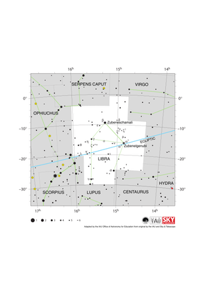
Libra Constellation Map
image
Caption: The constellation Libra along with its bright stars and surrounding constellations. Libra is surrounded by (going clockwise from the top) Serpens Caput, Virgo, Hydra, Centaurus, Lupus, Scorpius and Ophiuchus. Libra lies on the ecliptic (shown here as a blue line), this is the path the Sun appears to take across the sky over the course of a year. The Sun is in Libra from late October to late November. The other planets of the Solar System can often be found in Libra.
Libra lies just south of the celestial equator and is thus visible at some time in all but the most arctic regions. Libra is most visible in the evenings in the northern hemisphere late spring/early summer and southern hemisphere late autumn/early winter.
The y-axis of this diagram is in degrees of declination with north as up and the x-axis is in hours of right ascension with east to the left. The sizes of the stars marked here relate to the star's apparent magnitude, a measure of its apparent brightness. The larger dots represent brighter stars. The Greek letters mark the brightest stars in the constellation. These are ranked by brightness with the brightest star being labeled alpha, the second brightest beta, etc., although this ordering is not always followed exactly. The dotted boundary lines mark the IAU's boundaries of the constellations and the solid green lines mark one of the common forms used to represent the figures of the constellations. Neither the constellation boundaries, nor the line marking the ecliptic, nor the lines joining the stars appear on the sky.
Credit: Adapted by the IAU Office of Astronomy for Education from the original by IAU/Sky & Telescope
Credit Link
Glossary Terms:
Apparent Magnitude , Celestial Coordinates , Constellation , Declination , Ecliptic , Libra , Right Ascension (RA) , Scorpius , Zodiac , Virgo
Categories:
Naked Eye Astronomy
License: Creative Commons Attribution 4.0 International (CC BY 4.0) Creative Commons Attribution 4.0 International (CC BY 4.0) icons
File
( image
101.25 kB)
PDF File
(PDF file
181.72 kB)