文档与资源 - 搜索结果
搜索结果

Latitude and Longitude
图像
为 OAE 制作
图注: Two views of the Earth, one viewing the Northern Hemisphere, one viewing the Southern Hemisphere. The Earth rotates around its axis, an imaginary line that runs through the Earth from the North Pole to the South Pole. The Equator is an imaginary line that is the same distant from both the North Pole and the South Pole.
The positions of two cities, Rome in the Northern Hemisphere and Sydney in the Southern Hemisphere are marked here with red dots. Arrows indicate the two spherical coordinates latitude and longitude.
Latitude marks the position north or south of the equator. Here we can see Rome has the letter N in its latitude as it is in the Northern Hemisphere and Sydney has the letter S in its latitude as it is in the Southern Hemisphere. Latitude can vary from 90° N at the North Pole to 0° at the Equator to 90° S at the South Pole.
Longitude measures the position around the equator. While the choice of the zero point for latitude as the equator seems obvious, the choice of the zero point for longitude is more subjective. By convention the zero point in longitude is the prime meridian which passes through the Royal Greenwich Observatory in the UK. This is marked here as a solid line originating at the North Pole. Longitude is measured in degrees east or west of the prime meridian. As both Rome and Sydney lie to the east of Greenwich, they have the letter E as part of their longitude. Moving west to east, longitude varies from 180° W on the other side of the world from the prime meridian to 0° on the prime meridian before reaching 180° E again on the other side of world from the prime meridian.
This diagram shows the Earth at the December solstice. Two views are presented, one viewing the Northern Hemisphere and one viewing the Southern Hemisphere about nine hours later. The shaded region shows the night side of the Earth, with the day side being lighter. As it is the December solstice, the Sun appears overhead at the Tropic of Capricorn. This is a line of constant latitude at 23°26′09.3″ S. Six months later, at the June solstice, the Sun will appear to be overhead at the Tropic of Cancer at 23°26′09.3″ N. As the Sun appears over the Tropic of Capricorn more of the Southern Hemisphere is illuminated than the Northern Hemisphere. Indeed below the Antarctic Circle (the Polar Circle around the South Pole) the Sun does not set at this time of year leading to a Polar Day. Conversely, north of the Arctic Circle (the Polar Circle around the North Pole) the Sun does not rise at this time of year, leading to a Polar Night.
来源: Maria Cristina Fortuna/IAU OAE
词汇表:
地球自转 , 赤道 , 纬度 , 经度 , 极圈 , 地轴 , 回归线 , 极昼 , 极夜 , 北回归线 , 南回归线 , 热带地区 , 北极 , 南极
分类:
肉眼天文学
授权许可: 知识共享许可协议 署名 4.0 国际 (CC BY 4.0) 知识共享许可协议 署名 4.0 国际 (CC BY 4.0) 图标
文件
( 图像
434.22 kB)
PDF 文件
(PDF file
449.61 kB)
Also available in black and white
文件
( 图像
433.51 kB)
PDF 文件
(
358.89 kB)

International Date Line
图像
为 OAE 制作
图注: The International Date Line (shown here as a solid line) is a specific meridian which roughly follows the meridian of longitude 180°. The International Date Line passes north–south between Russia and Alaska, through the Pacific Ocean including parts of Micronesia and Polynesia, and to the east of Australia/New Zealand before reaching the South Pole on Antarctica. The International Date Line marks the boundary where calendar dates change by one. Therefore, regions to the west of the International Date line are one calendar day ahead of regions to the east.
The International Date Line does not always exactly follow the meridian of longitude 180°. This is partly to stop some territory of a country falling on the other side of the International Date Line than the rest of that country (the Aleutian Islands in the United States being a good example). Some countries also choose which side of the International Date Line they lie on. Samoa changed which side of the date line it lay on in 2011. At this point the International Date Line was moved to lie to the east of Samoa having previously passed to the west of Samoa.
On the opposite side of the world the dashed line marks the prime meridian (the meridian of longitude 0°). This is a line that passes through the Royal Greenwich Observatory in the UK. All time zones are measure relative to Universal Time which is the zero point for all timezones. The time zones marked at the top of the diagram are the timezones in the shaded regions excluding the effects of daylight savings time.
来源: Maria Cristina Fortuna/IAU OAE
词汇表:
时区 , 世界时(UT) , 本初子午线 , 国际日期变更线
分类:
天文学与社会
, 地球
授权许可: 知识共享许可协议 署名 4.0 国际 (CC BY 4.0) 知识共享许可协议 署名 4.0 国际 (CC BY 4.0) 图标
文件
( 图像
214.47 kB)
PDF 文件
(PDF file
88.40 kB)
Also available in black and white
文件
( 图像
272.39 kB)
PDF 文件
(
88.60 kB)
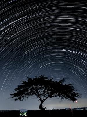
博特尔四级光污染下的南半球星轨
图像
为 OAE 制作
图注: 这张令人叹为观止的照片是 2020 年 6 月 25 日在印度尼西亚西爪哇库宁安省西里穆斯市凌加梅卡村的晴朗夜空下拍摄的,照片中的星轨掠过南半球的天际。星轨是地球自转所导致的恒星表观运动,当长时间跟踪时,就会产生这些令人着迷的光弧。因为这张照片是在赤道附近拍摄的,所以恒星所围绕旋转的点(南天极)靠近地平线。摄影师使用智能手机上的星轨功能,在较长时间内拍摄了一系列图像,并将它们叠加在一起。前景引人注目的大树增添了画面的深度,使上方天体的运动与地面的静止形成了鲜明对比,同时也遮掩了周围的一些光污染。世界不同地区的夜空景色各异,令人惊叹,使人们意识到保护各地黑暗天空的重要性。
来源: Slamat Riyadi/IAU OAE (CC BY 4.0)
词汇表:
天极 , 天球 , 地球自转
分类:
肉眼天文学
标签:
astrophotography
授权许可: 知识共享许可协议 署名 4.0 国际 (CC BY 4.0) 知识共享许可协议 署名 4.0 国际 (CC BY 4.0) 图标
此文件在 Zenodo 上 ( 图像 5.35 MB)
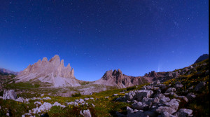
北斗七星和新智彗星 C2020 F3
视频
为 OAE 制作
图注: 这段延时摄影记录了2020年7月拍摄的三帧画面中标志性的北斗七星的轨迹。影像在意大利的三个地点拍摄:拉瓦雷多三峰(Tre Cime di Lavaredo)奥隆佐迪卡多雷、里特山(Monte Rite)奇比亚纳迪卡多雷,以及拉佐牧场(Casera Razzo)维戈迪卡多雷。这场视觉奥德赛展示了北斗七星的迷人轨迹,并在夜空中绘制出天体画卷。它不仅描绘了这个著名星群的轨迹,还捕捉到2020年7月照亮天空的罕见新智彗星 C/2020 F3 这一非凡的天文事件,为我们的夜空增添了光彩。
来源: 乔尔贾·霍弗/国际天文学联合会教育办公室 (CC BY 4.0)
词汇表:
北斗七星 , 天极 , 天球 , 拱极星 , 北极星 , 天空 , 自转
分类:
肉眼天文学
标签:
astrophotography
授权许可: 知识共享许可协议 署名 4.0 国际 (CC BY 4.0) 知识共享许可协议 署名 4.0 国际 (CC BY 4.0) 图标
此文件在 Zenodo 上 ( 视频 51.23 MB)
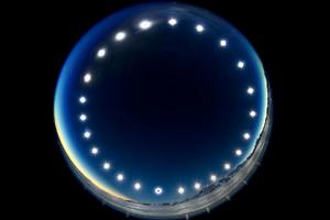
日食钟——极昼中的日食
图像
为 OAE 制作
图注: 这幅图像是于2021年12月4日的日全食期间在南极洲的联合冰川拍摄的,由24小时内先后拍摄到的多张照片组合而成,展示了太阳的昼弧。它展示了被称为“极昼”的独特现象——在极昼中,太阳在天空中巡行而不落下。在极昼期间,极圈内的地区会经历24小时的连续日照,太阳长时间不落山。这幅图像还提供了罕见的日食视角——从地球看去,月球从太阳和地球之间穿过。在图像最下方的太阳照片中,月球覆盖了太阳圆面。
来源: Stephanie Ziyi Ye/IAU OAE (CC BY 4.0)
词汇表:
太阳路径(日弧) , 日全食 , 极圈
分类:
肉眼天文学
, 太阳系
标签:
astrophotography
授权许可: 知识共享许可协议 署名 4.0 国际 (CC BY 4.0) 知识共享许可协议 署名 4.0 国际 (CC BY 4.0) 图标
此文件在 Zenodo 上 ( 图像 1.23 MB)