文档与资源 - 搜索结果
搜索结果

Seasons
图像
为 OAE 制作
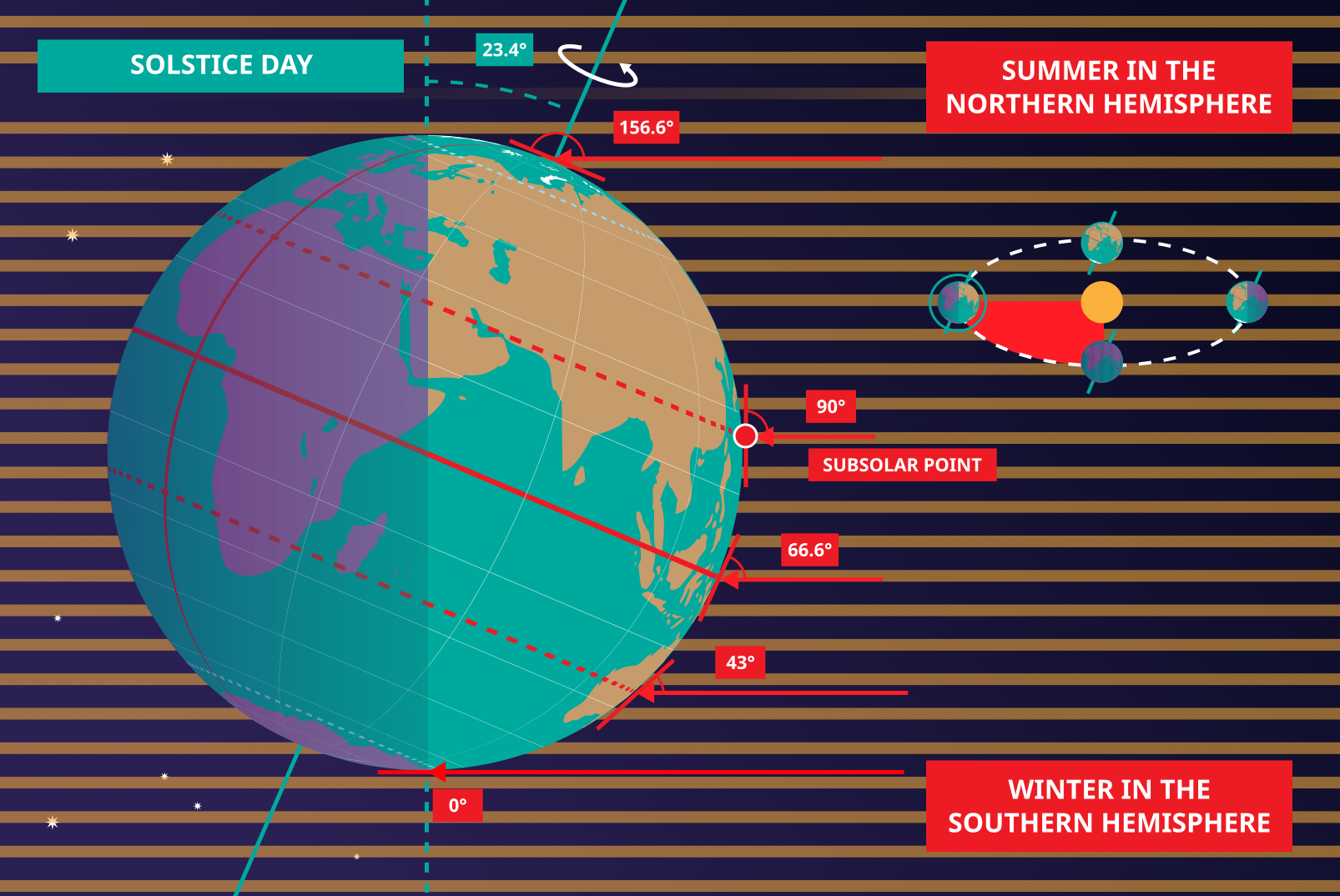
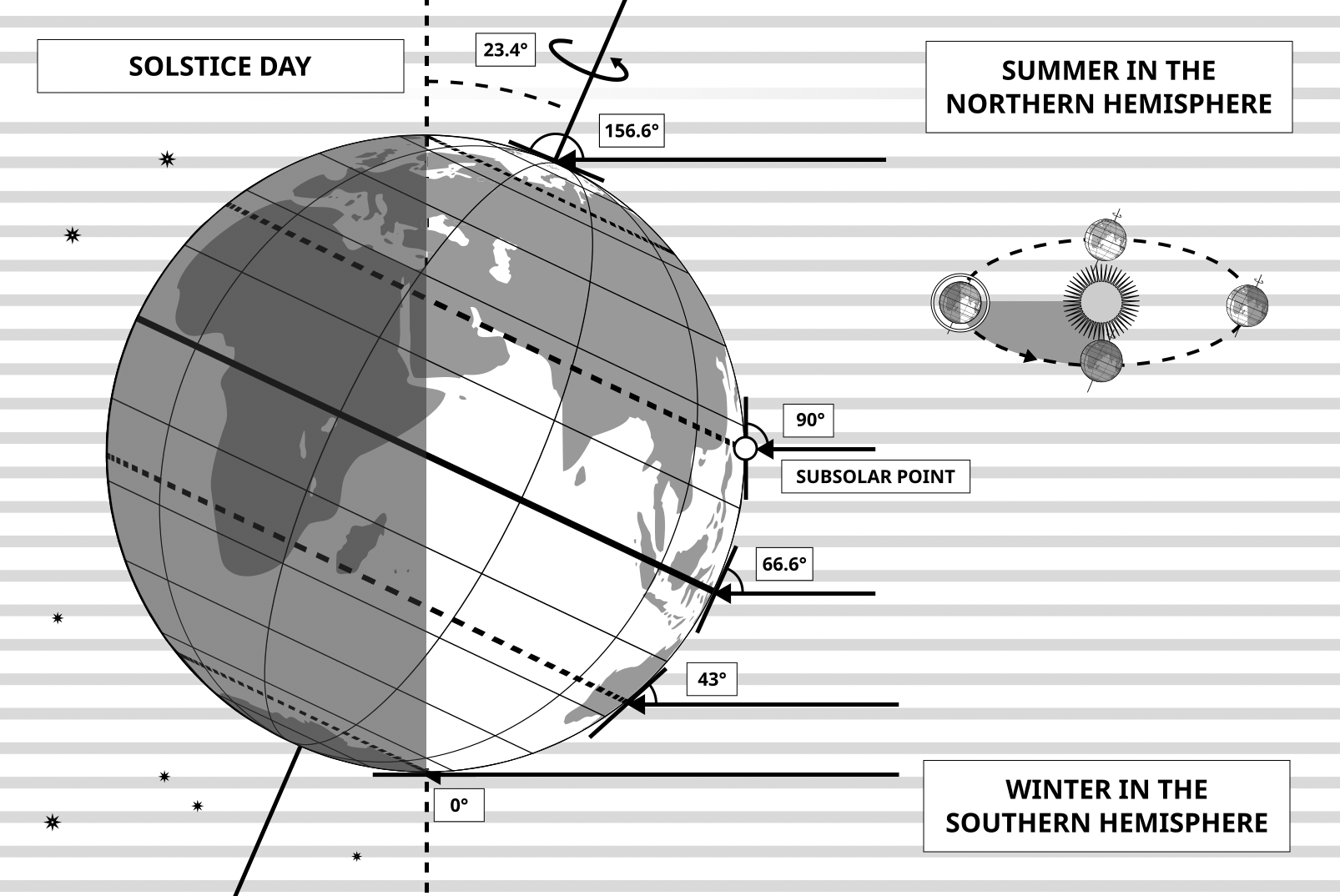
图注: This diagram shows the Earth at the June solstice which is known as the summer solstice in the Northern Hemisphere and the winter solstice in the Southern Hemisphere. The Earth’s axis of rotation is tilted from the axis of the Earth’s orbit around the Sun by 23.4°. Here we see light from the sun represented as parallel lines, in the diagram the Sun would lie far off the right-hand edge. Five lines are marked with angles. These lines hit the Earth at special latitudes. From top to bottom these lines hit the Earth at the North Pole, the Tropic of Cancer, the Equator, the Tropic of Capricorn and the Antarctic Circle. The lines are shown hitting the Earth at the longitude where it is currently noon. For the last four lines, the angles marked show the angle above the horizon (the altitude) which the Sun appears in the sky at at local noon.
At the June solstice, the Sun will appear directly overhead at local noon on every point on the Tropic of Capricorn. By contrast the Sun reaches a maximum altitude of 0° at local noon on every point in the Antarctic Circle. This means the Sun never rises and every point south of the Antarctic Circle experiences a long Polar Night. By contrast the Sun never sets on this day north of the Arctic Circle and the regions here experience a Polar Day. The at the North Pole the Sun will remain at a constant altitude all day. This altitude will be the angle 180°-156.6° (23.4°).
The altitude the Sun appears at is important as it defines how spread out the Sun’s rays are on the Earth’s surface. Look at the thick, faint parallel lines in the background. Notice how at the Tropic of Cancer the area the lines intersect with the Earth’s surface perpendicularly and the line only covers a small part of the Earth’s surface. Now look at a line near the Tropic of Capricorn and see that this intersects with the Earth at a grazing angle and the line is spread out, covering a much wider area of the Earth’s surface. This means that a given amount of light from the Sun that hits the Tropic of Cancer is more concentrated and the same amount of light hitting the Tropic of Capricorn would be more spread out. This leads to more energy per unit area from the Sun hitting the Tropic of Cancer and less energy per unit area hitting the Tropic of Capricorn. This means it will be warmer at the Tropic of Cancer than at the Tropic of Capricorn. It is thus summer at the Tropic of Cancer and winter at the Tropic of Capricorn.
Six months later this situation will be reversed and it will be summer at the Tropic of Capricorn and winter at the Tropic of Cancer.
来源: Maria Cristina Fortuna/IAU OAE
词汇表:
赤道 , 二至点 , 夏至 , 冬季 , 冬至 , 北极圈 , 南极圈 , 北回归线 , 南回归线 , 北极
授权许可: 知识共享许可协议 署名 4.0 国际 (CC BY 4.0) 知识共享许可协议 署名 4.0 国际 (CC BY 4.0) 图标
文件
( 图像
1.09 MB)
Also available in black and white
文件
( 图像
400.17 kB)
PDF 文件
(
477.01 kB)

Solstices and Equinoxes
图像
为 OAE 制作
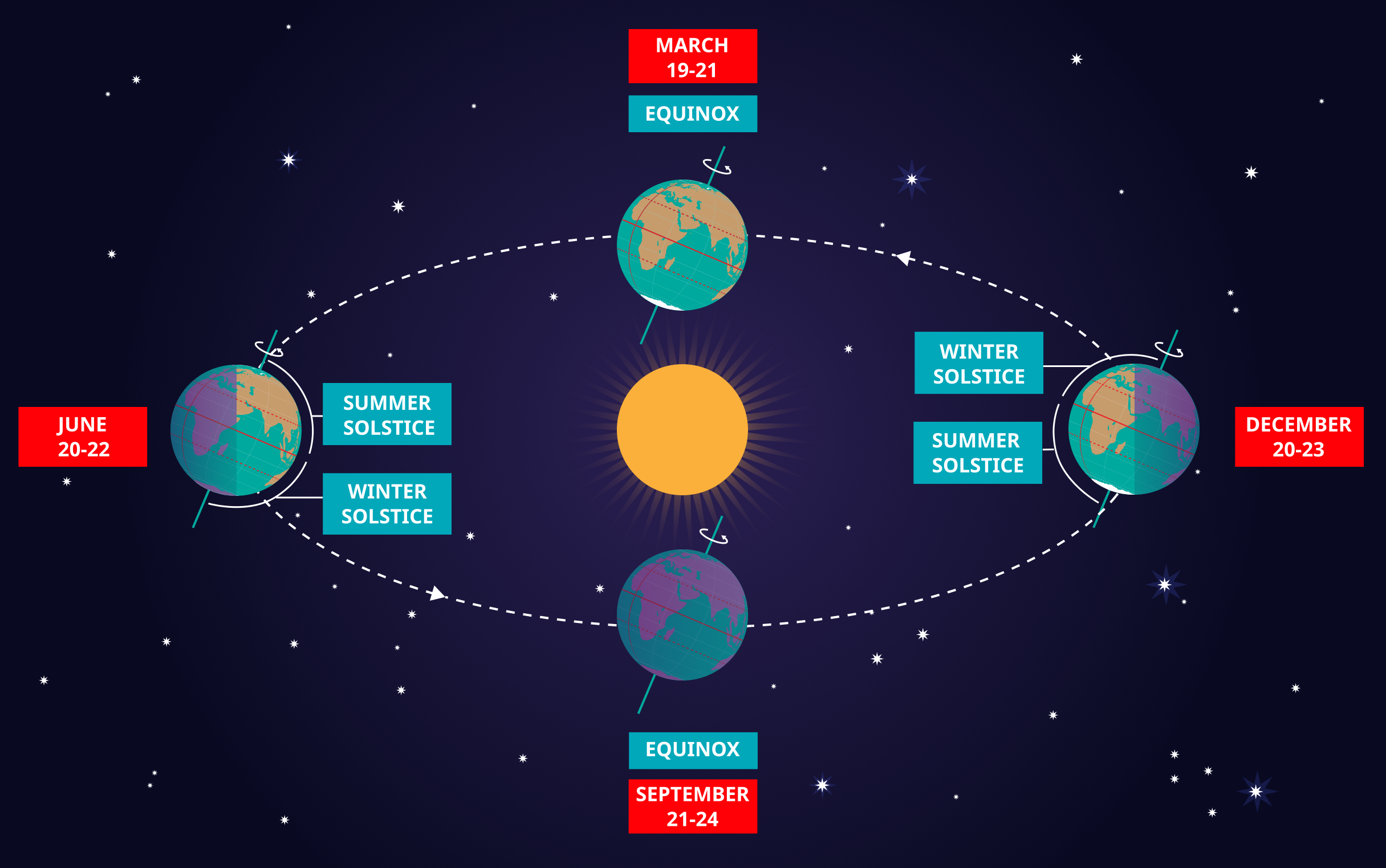
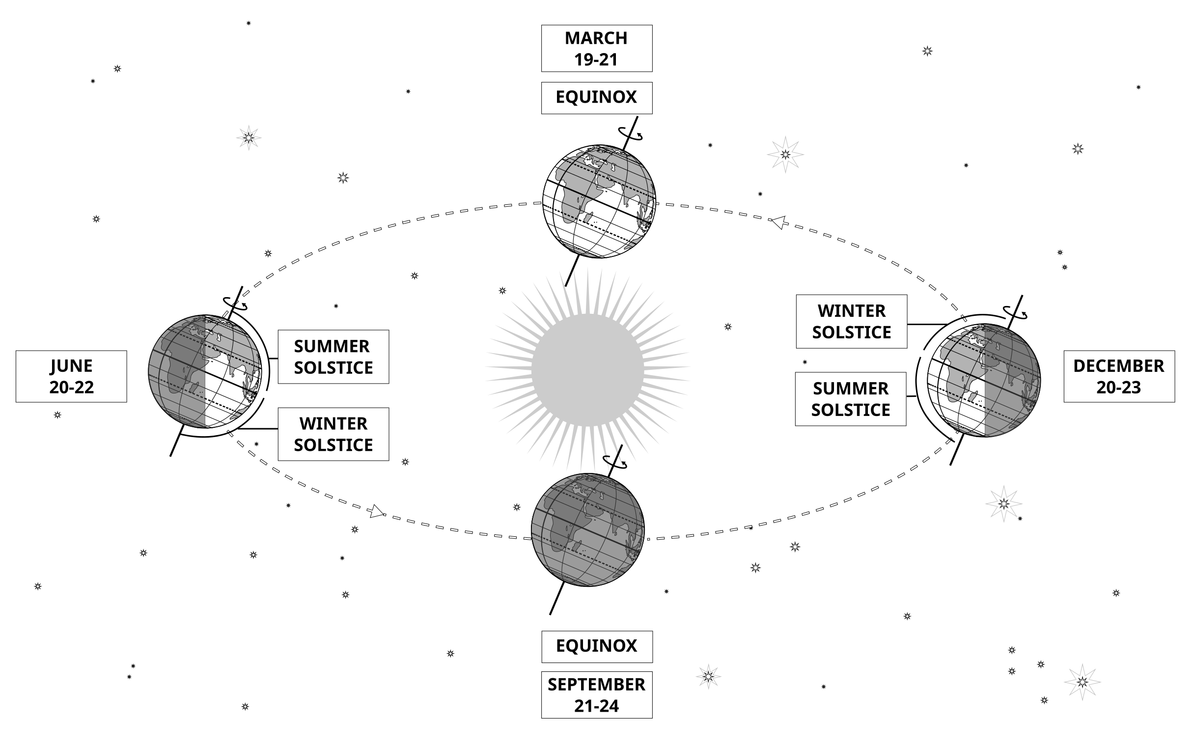
图注: This diagram demonstrates the relative positions of the Earth and Sun at the two solstices and two equinoxes. The Earth’s rotation axis is tilted by 23.4° from the axis of its orbit. This means that for half the Earth’s annual orbit around the Sun, the Southern Hemisphere is tilted towards the Sun and the Northern Hemisphere is tilted away from the Sun. During this time the Sun appears to lie below the celestial equator. Due to this at any particular point in the Southern Hemisphere the Sun will appear to be higher above the horizon at a particular time of day and the days will be longer. Conversely during this time, the Sun appears lower in the sky at any particular point in the day in the Northern Hemisphere and the days are shorter.
This effect is most pronounced in late December when the Sun appears at its most southerly point in the sky, corresponding to the longest day of the year in the Southern Hemisphere. This normally occurs on the 21st or 22nd of December (UTC), depending on when the most recent leap year was, but can very occasionally occur on the 20th or 23rd of December. This event is known as the December solstice. As the Sun’s rays hit the Southern Hemisphere at a more perpendicular angle during this time, the Southern Hemisphere is typically warmer in this time of year than at other times of year. This is often referred to as summer in temperate and antarctic regions of the Southern Hemisphere and thus the December solstice is known as the summer solstice. South of the Antarctic Circle at this time the Sun never sets and a Polar Day can last several months. Conversely in the Northern Hemisphere, the Sun’s rays hit the Earth at a more grazing angle than at other times of year so it is colder and this solstice is known as the winter solstice. North of the Arctic Circle the Sun never rises during this time and the Polar Night can last several months.
As the year progresses the Earth moves in its orbit and the tilt of the Earth’s axis moves so it appears more side-on to the Sun. From the perspective of an observer on Earth this means that the Sun moves north in the sky, eventually reaching the celestial equator in late March, This usually occurs on the 20th of March (UTC) but can sometimes occur on the 19th or 21st of March. During this time all places on Earth will experience night and day that is approximately 12 hours long. The Sun’s rays now hit the Southern hemisphere at a more shallow angle than they did in December and hit the Northern Hemisphere at a more perpendicular angle. This means that the Northen Hemisphere will have warmed since December and the Southern Hemisphere cooled. This leads to the March equinox being referred to as the autumn equinox in the Southern Hemisphere and the spring or vernal equinox in the Northern Hemisphere.
As the year progresses further the Sun moves further north on the sky, the Northern Hemisphere days lengthen and the Southern Hemisphere days shorten. By June the Earth’s orbit has progressed to the point where the Northern Hemisphere points towards the Sun and the Southern Hemisphere away from the Sun. At one point between the 20th and 22nd of June (UTC) the Sun reaches its most northerly point in the sky, this is known as June solstice. It is now summer in northern temperate and artic regions so this is known as the summer solstice in the Northern Hemisphere and the winter solstice in the Southern Hemisphere. This is the longest day of the year in the Northern Hemisphere and the shortest day of the year in the Southern Hemisphere. During this time regions north of the Arctic Circle experience a long Polar Day and regions south of the Antarctic Circle experience polar night.
The year progresses further and the Earth moves in its orbit so that the tilt of the Earth’s axis again appears side-on for the Sun. The Sun moves south in the sky and again crosses the celestial equator between the 21st and 24th of September (UTC). At this time all places on the Earth experience equal lengths of day and night. This is known as the September equinox, also called the spring or vernal equinox in the Southern Hemisphere and the autumn equinox in the Northern Hemisphere.
Note the sizes of the Earth, Sun and the Earth’s orbit around the Sun are not to scale in this diagram.
来源: Maria Cristina Fortuna/IAU OAE
词汇表:
昼夜平分点 , 天赤道 , 季节 , 二至点 , 夏至 , 冬至 , 春分 , 秋分 , 地轴 , 北极圈 , 南极圈 , 极昼 , 极夜
分类:
肉眼天文学
授权许可: 知识共享许可协议 署名 4.0 国际 (CC BY 4.0) 知识共享许可协议 署名 4.0 国际 (CC BY 4.0) 图标
文件
( 图像
2.02 MB)
PDF 文件
(PDF file
335.83 kB)
Also available in black and white
文件
( 图像
485.38 kB)
PDF 文件
(
388.16 kB)

Latitude and Longitude
图像
为 OAE 制作
图注: Two views of the Earth, one viewing the Northern Hemisphere, one viewing the Southern Hemisphere. The Earth rotates around its axis, an imaginary line that runs through the Earth from the North Pole to the South Pole. The Equator is an imaginary line that is the same distant from both the North Pole and the South Pole.
The positions of two cities, Rome in the Northern Hemisphere and Sydney in the Southern Hemisphere are marked here with red dots. Arrows indicate the two spherical coordinates latitude and longitude.
Latitude marks the position north or south of the equator. Here we can see Rome has the letter N in its latitude as it is in the Northern Hemisphere and Sydney has the letter S in its latitude as it is in the Southern Hemisphere. Latitude can vary from 90° N at the North Pole to 0° at the Equator to 90° S at the South Pole.
Longitude measures the position around the equator. While the choice of the zero point for latitude as the equator seems obvious, the choice of the zero point for longitude is more subjective. By convention the zero point in longitude is the prime meridian which passes through the Royal Greenwich Observatory in the UK. This is marked here as a solid line originating at the North Pole. Longitude is measured in degrees east or west of the prime meridian. As both Rome and Sydney lie to the east of Greenwich, they have the letter E as part of their longitude. Moving west to east, longitude varies from 180° W on the other side of the world from the prime meridian to 0° on the prime meridian before reaching 180° E again on the other side of world from the prime meridian.
This diagram shows the Earth at the December solstice. Two views are presented, one viewing the Northern Hemisphere and one viewing the Southern Hemisphere about nine hours later. The shaded region shows the night side of the Earth, with the day side being lighter. As it is the December solstice, the Sun appears overhead at the Tropic of Capricorn. This is a line of constant latitude at 23°26′09.3″ S. Six months later, at the June solstice, the Sun will appear to be overhead at the Tropic of Cancer at 23°26′09.3″ N. As the Sun appears over the Tropic of Capricorn more of the Southern Hemisphere is illuminated than the Northern Hemisphere. Indeed below the Antarctic Circle (the Polar Circle around the South Pole) the Sun does not set at this time of year leading to a Polar Day. Conversely, north of the Arctic Circle (the Polar Circle around the North Pole) the Sun does not rise at this time of year, leading to a Polar Night.
来源: Maria Cristina Fortuna/IAU OAE
词汇表:
地球自转 , 赤道 , 纬度 , 经度 , 极圈 , 地轴 , 回归线 , 极昼 , 极夜 , 北回归线 , 南回归线 , 热带地区 , 北极 , 南极
分类:
肉眼天文学
授权许可: 知识共享许可协议 署名 4.0 国际 (CC BY 4.0) 知识共享许可协议 署名 4.0 国际 (CC BY 4.0) 图标
文件
( 图像
434.22 kB)
PDF 文件
(PDF file
449.61 kB)
Also available in black and white
文件
( 图像
433.51 kB)
PDF 文件
(
358.89 kB)
每月日落的地方
图像
为 OAE 制作
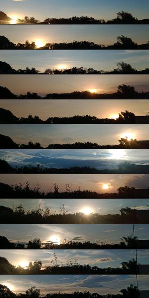
图注: 这组图片是在菲律宾布拉干省的圣拉斐尔用智能手机拍摄的,它捕捉到了地球轴向倾斜和环绕太阳运行所导致的日落位置在一年中的变化。从 2022 年 1 月到 12 月,每张图片都反映了黄昏时分背景和太阳位置的变化。在十月,可以观察到树叶的变化和一根电线杆的出现。这组作品是地球与太阳之间的天体舞蹈以及地面自然景观变化的视觉见证。
来源: John Paul Pile/IAU OAE (CC BY 4.0)
词汇表:
昼夜平分点 , 二至点 , 夏至 , 太阳路径(日弧) , 冬至
分类:
肉眼天文学
标签:
astrophotography
授权许可: 知识共享许可协议 署名 4.0 国际 (CC BY 4.0) 知识共享许可协议 署名 4.0 国际 (CC BY 4.0) 图标
此文件在 Zenodo 上 ( 图像 11.82 MB)
日食钟——极昼中的日食
图像
为 OAE 制作
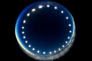
图注: 这幅图像是于2021年12月4日的日全食期间在南极洲的联合冰川拍摄的,由24小时内先后拍摄到的多张照片组合而成,展示了太阳的昼弧。它展示了被称为“极昼”的独特现象——在极昼中,太阳在天空中巡行而不落下。在极昼期间,极圈内的地区会经历24小时的连续日照,太阳长时间不落山。这幅图像还提供了罕见的日食视角——从地球看去,月球从太阳和地球之间穿过。在图像最下方的太阳照片中,月球覆盖了太阳圆面。
来源: Stephanie Ziyi Ye/IAU OAE (CC BY 4.0)
词汇表:
太阳路径(日弧) , 日全食 , 极圈
分类:
肉眼天文学
, 太阳系
标签:
astrophotography
授权许可: 知识共享许可协议 署名 4.0 国际 (CC BY 4.0) 知识共享许可协议 署名 4.0 国际 (CC BY 4.0) 图标
此文件在 Zenodo 上 ( 图像 1.23 MB)