文档与资源 - 搜索结果
搜索结果

Celestial Coordinates
图像
为 OAE 制作
图注: Here we see how celestial coordinates map positions on the celestial sphere. The celestial sphere is an imaginary, hollow sphere that surrounds the Earth. Celestial objects appear to be attached to the inside of the celestial sphere, and the planets, Sun, and Moon appear to move slowly across it.
The celestial sphere has a spherical coordinate system similar to the latitude and longitude we see on the Earth. The celestial equator is the projection of the Earth's equator onto the celestial sphere while the north and south celestial poles are the projections of the Earth's north and south poles onto the celestial sphere.
Declination is similar to latitude on the Earth in that it marks the angle above and below the celestial equator. Declination is zero on the celestial equator, is positive to the north of the celestial equator and negative to the south of it. It is commonly measured in degrees and sometimes in radians.
Right Ascension is similar to longitude as it marks the angle around the celestial equator. As with longitude the zero point of right ascension (shown here as a dashed line) is a matter of choice. Traditionally the zero point of right ascension was the position of the Sun at the northern hemisphere vernal equinox (spring equinox) in March. It is positive and increases to the east, unlike longitude on Earth which is defined as east or west of the prime meridian. It is most commonly measured in hours, minutes and seconds or occasionally in degrees or radians.
The ecliptic marks the Sun's path across the celestial sphere when viewed from the Earth.
The Earth rotates within the celestial sphere. This leads to objects like stars or galaxies, which appear static on the celestial sphere, rising and setting when viewed from the Earth but remaining in the same position on the celestial sphere.
The Earth's axis precesses within the celestial sphere. This slowly moves the celestial equator and the celestial poles meaning that the traditional celestial coordinate system changes slowly over time meaning that stars and galaxies that do not move will have positions that change. Astronomers have used coordinate systems defined by the position of the celestial poles and equator at a fixed point in time. Now celestial positions are most commonly measured on a fixed coordinate system defined by the position of the celestial poles and equator on the 1st of January 2000.
来源: Maria Cristina Fortuna/IAU OAE
分类:
肉眼天文学
, 观测天文学
授权许可: 知识共享许可协议 署名 4.0 国际 (CC BY 4.0) 知识共享许可协议 署名 4.0 国际 (CC BY 4.0) 图标
文件
( 图像
517.83 kB)
PDF 文件
(PDF file
203.59 kB)
Also available in black and white
文件
( 图像
501.79 kB)
PDF 文件
(
202.13 kB)
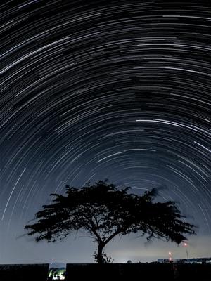
博特尔四级光污染下的南半球星轨
图像
为 OAE 制作
图注: 这张令人叹为观止的照片是 2020 年 6 月 25 日在印度尼西亚西爪哇库宁安省西里穆斯市凌加梅卡村的晴朗夜空下拍摄的,照片中的星轨掠过南半球的天际。星轨是地球自转所导致的恒星表观运动,当长时间跟踪时,就会产生这些令人着迷的光弧。因为这张照片是在赤道附近拍摄的,所以恒星所围绕旋转的点(南天极)靠近地平线。摄影师使用智能手机上的星轨功能,在较长时间内拍摄了一系列图像,并将它们叠加在一起。前景引人注目的大树增添了画面的深度,使上方天体的运动与地面的静止形成了鲜明对比,同时也遮掩了周围的一些光污染。世界不同地区的夜空景色各异,令人惊叹,使人们意识到保护各地黑暗天空的重要性。
来源: Slamat Riyadi/IAU OAE (CC BY 4.0)
词汇表:
天极 , 天球 , 地球自转
分类:
肉眼天文学
标签:
astrophotography
授权许可: 知识共享许可协议 署名 4.0 国际 (CC BY 4.0) 知识共享许可协议 署名 4.0 国际 (CC BY 4.0) 图标
此文件在 Zenodo 上 ( 图像 5.35 MB)

白昼的最后一小时
图像
为 OAE 制作
图注: 这幅 1997 年 5 月 2 日在意大利斯卡法奥罗湖拍摄的作品,巧妙地捕捉了太阳落下时在平静的水面上一连串的镜面反射。这一场景,令人惊叹地展示了时间的流逝以及周围环境的宁静之美,是白昼稍纵即逝的最后时刻的永恒见证。
来源: Fabrizio Melandri/IAU OAE (CC BY 4.0)
词汇表:
太阳路径(日弧)
分类:
肉眼天文学
标签:
astrophotography
授权许可: 知识共享许可协议 署名 4.0 国际 (CC BY 4.0) 知识共享许可协议 署名 4.0 国际 (CC BY 4.0) 图标
此文件在 Zenodo 上 ( 图像 940.09 kB)
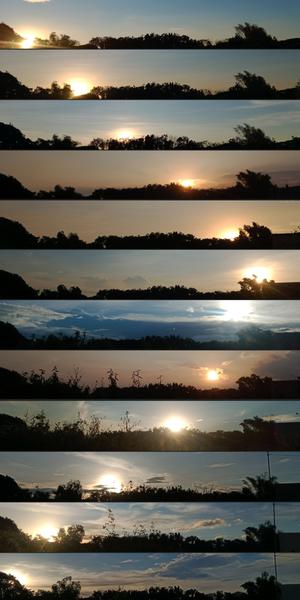
每月日落的地方
图像
为 OAE 制作
图注: 这组图片是在菲律宾布拉干省的圣拉斐尔用智能手机拍摄的,它捕捉到了地球轴向倾斜和环绕太阳运行所导致的日落位置在一年中的变化。从 2022 年 1 月到 12 月,每张图片都反映了黄昏时分背景和太阳位置的变化。在十月,可以观察到树叶的变化和一根电线杆的出现。这组作品是地球与太阳之间的天体舞蹈以及地面自然景观变化的视觉见证。
来源: John Paul Pile/IAU OAE (CC BY 4.0)
词汇表:
昼夜平分点 , 二至点 , 夏至 , 太阳路径(日弧) , 冬至
分类:
肉眼天文学
标签:
astrophotography
授权许可: 知识共享许可协议 署名 4.0 国际 (CC BY 4.0) 知识共享许可协议 署名 4.0 国际 (CC BY 4.0) 图标
此文件在 Zenodo 上 ( 图像 11.82 MB)
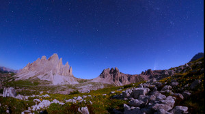
北斗七星和新智彗星 C2020 F3
视频
为 OAE 制作
图注: 这段延时摄影记录了2020年7月拍摄的三帧画面中标志性的北斗七星的轨迹。影像在意大利的三个地点拍摄:拉瓦雷多三峰(Tre Cime di Lavaredo)奥隆佐迪卡多雷、里特山(Monte Rite)奇比亚纳迪卡多雷,以及拉佐牧场(Casera Razzo)维戈迪卡多雷。这场视觉奥德赛展示了北斗七星的迷人轨迹,并在夜空中绘制出天体画卷。它不仅描绘了这个著名星群的轨迹,还捕捉到2020年7月照亮天空的罕见新智彗星 C/2020 F3 这一非凡的天文事件,为我们的夜空增添了光彩。
来源: 乔尔贾·霍弗/国际天文学联合会教育办公室 (CC BY 4.0)
词汇表:
北斗七星 , 天极 , 天球 , 拱极星 , 北极星 , 天空 , 自转
分类:
肉眼天文学
标签:
astrophotography
授权许可: 知识共享许可协议 署名 4.0 国际 (CC BY 4.0) 知识共享许可协议 署名 4.0 国际 (CC BY 4.0) 图标
此文件在 Zenodo 上 ( 视频 51.23 MB)