بلغات أخرى
- الألمانيّة: Künstlicher Satellit
- الإنجليزيّة: Artificial Satellite
- الإسبانيّة: Satélite Artificial
- الفرنسيّة: Satellite artificiel
- الهندية: कृत्रिम उपग्रह
- الإيطاليّة: Satellite artificiale
- اليابانيّة: 人工衛星 (رابط خارجي)
- الكوريّة: 인공 위성
- المهاراتية: कृत्रिम उपग्रह
- البرتغاليّة البرازيليّة: Satélite artificial
- الصينيّة المبسطة: 人造卫星
- الصينيّة التقليدية: 人造衛星
وسائط ذات صلة
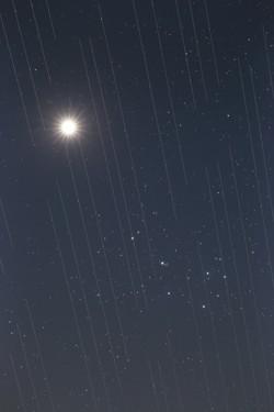
Satellite swarm versus night sky beauty, by Torsten Hansen, Germany
الشرح: Third place in the 2021 IAU OAE Astrophotography Contest, category Light pollution.
This image of Venus and the Pleiades also shows the tracks of the Starlink satellites. These satellites which are located at an altitude of approximately 550 kilometres, are part of an ever-growing constellation of satellites aimed to provide worldwide internet access. The reflective surfaces of the satellites, coupled with the fact that they are orbiting around the Earth, means that astronomical observations which require very long exposures capture “tracks” of the satellites in their images. Astronomical images used for scientific research are not usable because the measurements and data will contain these “tracks”. Because the number of satellites is expected to grow, it is likely that in the near future there will be no place on Earth where these satellites will not be visible crossing the sky. This is a new type of light pollution that seems to be an upcoming problem we will have to deal with, as these satellites might prevent optimal observation of the sky.
المصدر: Torsten Hansen/IAU OAE
License: CC-BY-4.0 المشاع الإبداعي نَسب المُصنَّف 4.0 دولي (CC BY 4.0) أيقونات
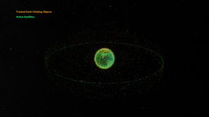
Space debris orbiting the Earth
الشرح: This animation shows objects orbiting the Earth. The data date from February 2024 and are taken from space-track.org which maintains a public catalogue of objects tracked by the United States Space Command (USSPACECOM).
At first in this video we see green dots, each representing one of the 31,000 human-made objects orbiting Earth. These include both operational and decommissioned satellites, used rocket stages from space launches, and fragments larger than 10cm created by collisions or explosions. Later in the video, some of the green dots are replace by orange dots, each of these representing one of the 9,300 operational satellites orbiting the Earth. Note that since February 2024 more satellites and rockets have been launched in to space and some objects will have fallen back to Earth, so these numbers will have changed.
We see two main groups of objects. The first are those objects orbiting close to the Earth, objects in low Earth orbit. These include communication satellites (many from the satellite constellations used to provide satellite internet services), Earth observation satellites, military satellites, two operational space stations and other objects such as rocket stages and other debris.
More distant from Earth we see a thin ring of satellites. These are in geostationary orbit. This is a special orbit where the orbital period matches the rotation period of the Earth. This means that a satellite in geostationary orbit stays above the same point on the equator and, when observed from the side of the Earth facing the satellite, will appear to stay at a position on the sky that does not change over time. Because of this, geostationary orbit is used by many communications satellites as a satellite dish on Earth used to receive or transmit a signal to that satellite can point in a fixed direction and does not need to dynamically track the satellite. Geostationary orbit is also used by weather observation satellites.
المصدر: NASA's Scientific Visualization Studio
رابط المصدر
License: PD الملكية العامة أيقونات
الأنشطة المرتبطة
Valleys Deep and Mountains High
astroEDU educational activity (links to astroEDU website) Description: Learn how radar altimetry from satellites works and how to put landscapes on paper.
License: CC-BY-4.0 المشاع الإبداعي نَسب المُصنَّف 4.0 دولي (CC BY 4.0) أيقونات
وسوم:
Maps
, Earth observation
, Sentinel
, Copernicus
, Remote sensing
, Altimetry
, Radar
الفئات العمرية:
14-16
, 16-19
المرحلة التعليمية:
المرحلة المتوسطة
, المرحلة الثانوية
مجالات التعلم:
مجموعات نقاش
, النمذجة
, تعلم منظم قائم على الاستقصاء
التكاليف:
تكلفة متوسطة
المدة:
ساعتان
حجم المجموعة:
جماعي
المهارات:
تحليل البيانات وتفسيرها
, طرح الأسئلة
, توصيل المعلومات
, تطوير النماذج واستخدامها
, استخدام الرياضيات والتفكير الحاسوبي
A View from Above
astroEDU educational activity (links to astroEDU website) Description: How do satellites take images of the Earth surface and how do we analyse and use them?
License: CC-BY-4.0 المشاع الإبداعي نَسب المُصنَّف 4.0 دولي (CC BY 4.0) أيقونات
وسوم:
Maps
, Climate
, Landsat
, Earth observation
, Sentinel
, Copernicus
, Remote sensing
, Vegetation
الفئات العمرية:
14-16
, 16-19
المرحلة التعليمية:
المرحلة المتوسطة
, المرحلة الثانوية
مجالات التعلم:
تعلم منظم قائم على الاستقصاء
التكاليف:
تكلفة منخفضة
المدة:
ساعة ونصف
حجم المجموعة:
جماعي
المهارات:
تحليل البيانات وتفسيرها
, طرح الأسئلة
, توصيل المعلومات
, صياغة التفسيرات
, تطوير النماذج واستخدامها
, بناء حجج استنادًا إلى الأدلة
, استخدام الرياضيات والتفكير الحاسوبي
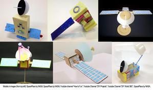
Build Your Own Artificial Satellite
astroEDU educational activity (links to astroEDU website) Description: Build a satellite to learn what they are made of and their uses.
License: CC-BY-4.0 المشاع الإبداعي نَسب المُصنَّف 4.0 دولي (CC BY 4.0) أيقونات
وسوم:
Art
, Creativity
, Hands-on
, Model
الفئات العمرية:
8-10
المرحلة التعليمية:
المرحلة الابتدائية
مجالات التعلم:
مجموعات نقاش
, محاضرة تفاعلية
, النمذجة
التكاليف:
تكلفة منخفضة
المدة:
ساعة ونصف
حجم المجموعة:
جماعي
المهارات:
توصيل المعلومات
, تطوير النماذج واستخدامها
Where on Earth am I?
astroEDU educational activity (links to astroEDU website) Description: How do satellite-based positioning and GPS navigation work?
License: CC-BY-4.0 المشاع الإبداعي نَسب المُصنَّف 4.0 دولي (CC BY 4.0) أيقونات
وسوم:
Clocks
, Geography
, Maps
, GPS
, Countries
, Speed of light
, Galileo
الفئات العمرية:
14-16
المرحلة التعليمية:
المرحلة المتوسطة
مجالات التعلم:
تعلم استكشافي موجه
, حل المشكلات
التكاليف:
تكلفة منخفضة
المدة:
ساعة ونصف
حجم المجموعة:
جماعي
المهارات:
تحليل البيانات وتفسيرها
, طرح الأسئلة
, توصيل المعلومات
, صياغة التفسيرات
, تطوير النماذج واستخدامها
, استخدام الرياضيات والتفكير الحاسوبي

