Glossary term: 导航
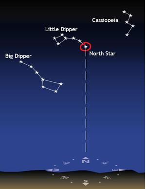
Description: 导航是确定自己在地球或太空中的位置、预定的行进方向以及如何到达目的地的过程。在历史上,太阳和星星在导航中起到了重要作用。最简单的情况,在北半球的晴朗夜晚,可以通过北极星确定北方的位置,并据此选择行进方向;而在南半球,南十字星指向的是南方。在现代导航设备发展之前,“天体导航”是导航的关键方法。导航员会通过测量中午太阳在地平线上的角度来推算自己的纬度,并通过比较当地中午时间(太阳位于天空最高点的时间)与显示格林威治标准时间的时钟,来确定自己的经度。现代导航主要依赖于GPS及类似卫星系统的信号。
Related Terms:
See this term in other languages
Term and definition status: The original definition of this term in English have been approved by a research astronomer and a teacher The translation of this term and its definition is still awaiting approval
The OAE Multilingual Glossary is a project of the IAU Office of Astronomy for Education (OAE) in collaboration with the IAU Office of Astronomy Outreach (OAO). The terms and definitions were chosen, written and reviewed by a collective effort from the OAE, the OAE Centers and Nodes, the OAE National Astronomy Education Coordinators (NAECs) and other volunteers. You can find a full list of credits here. All glossary terms and their definitions are released under a Creative Commons CC BY-4.0 license and should be credited to "IAU OAE".
If you notice a factual or translation error in this glossary term or definition then please get in touch.
Related Media

扬帆天海
Credit: 胡韵曦(音译)/国际天文学联合会教育办公室 (CC BY 4.0)
License: CC-BY-4.0 Creative Commons 署名 4.0 国际 (CC BY 4.0) icons

故宫星轨
Credit: Stephanie Ziyi Ye/IAU OAE (CC BY 4.0)
License: CC-BY-4.0 Creative Commons 署名 4.0 国际 (CC BY 4.0) icons
Related Activities

What is a Constellation?
astroEDU educational activity (links to astroEDU website) Description: Investigate three dimensional objects and perspective using constellations
License: CC-BY-4.0 Creative Commons 署名 4.0 国际 (CC BY 4.0) icons
Tags:
Hands-on
Age Ranges:
6-8
, 8-10
Education Level:
Primary
Areas of Learning:
Modelling
, Social Research
Costs:
Medium Cost
Duration:
1 hour 30 mins
Group Size:
Group
Skills:
Analysing and interpreting data
, Asking questions
, Constructing explanations
, Developing and using models
How To Travel on Earth Without Getting Lost
astroEDU educational activity (links to astroEDU website) Description: Use a globe to describe your position on Earth.
License: CC-BY-4.0 Creative Commons 署名 4.0 国际 (CC BY 4.0) icons
Tags:
Geography
, Maps
, GPS
, Celestial navigation
Age Ranges:
8-10
, 10-12
, 12-14
Education Level:
Middle School
, Primary
Areas of Learning:
Social Research
Costs:
Low Cost
Duration:
1 hour
Group Size:
Group
Skills:
Analysing and interpreting data
, Developing and using models
, Using mathematics and computational thinking
The Quest for Longitude
astroEDU educational activity (links to astroEDU website) Description: How to navigate at sea like an explorer?
License: CC-BY-4.0 Creative Commons 署名 4.0 国际 (CC BY 4.0) icons
Tags:
Clocks
, Geography
, Coordinates
, Celestial navigation
, James Cook
, Exploration
Age Ranges:
14-16
, 16-19
Education Level:
Middle School
, Secondary
Areas of Learning:
Discussion Groups
, Modelling
, Social Research
Costs:
Low Cost
Duration:
2 hours
Group Size:
Group
Skills:
Analysing and interpreting data
, Asking questions
, Communicating information
, Developing and using models
, Planning and carrying out investigations
, Using mathematics and computational thinking
Where on Earth am I?
astroEDU educational activity (links to astroEDU website) Description: How do satellite-based positioning and GPS navigation work?
License: CC-BY-4.0 Creative Commons 署名 4.0 国际 (CC BY 4.0) icons
Tags:
Clocks
, Geography
, Maps
, GPS
, Countries
, Speed of light
, Galileo
Age Ranges:
14-16
Education Level:
Middle School
Areas of Learning:
Guided-discovery learning
, Problem-solving
Costs:
Low Cost
Duration:
1 hour 30 mins
Group Size:
Group
Skills:
Analysing and interpreting data
, Asking questions
, Communicating information
, Constructing explanations
, Developing and using models
, Using mathematics and computational thinking
Navigate like a Viking – Use the Sun, not your phone!
astroEDU educational activity (links to astroEDU website) Description: Learn how the Vikings used the sky to navigate at sea with a hands-on activity!
License: CC-BY-4.0 Creative Commons 署名 4.0 国际 (CC BY 4.0) icons
Tags:
History
, Geography
, Maps
, Coordinates
, Celestial navigation
Age Ranges:
12-14
, 14-16
Education Level:
Middle School
Areas of Learning:
Discussion Groups
, Modelling
, Social Research
Costs:
Medium Cost
Duration:
1 hour 30 mins
Group Size:
Group
Skills:
Analysing and interpreting data
, Asking questions
, Communicating information
, Developing and using models
, Planning and carrying out investigations
, Using mathematics and computational thinking