Loading...

Glossary term: 拱极星

Description: 在地球上的大多数地方,都能在地平线以上一定距离的天空中看到北天极或南天极。对于处于这样一个位置的观测者来说,随着时间的流逝,星星似乎在围绕着天极旋转:每颗恒星都在天空中划出一个圆圈,其中心是地轴指向的天极。在圆圈与观测者地平线相交的两点,即东点和西点,该恒星将分别升起和落下。对于距离天极足够近的恒星,其划出的圆圈将完全位于地平线之上。我们的观测者将永远看不到这些恒星升起或落下。这些永不落下的恒星被称为拱极星。

哪些恒星是拱极星取决于观测者的地理纬度和恒星的赤纬——后者是恒星所在位置与天赤道之间的夹角。在北半球,如果一颗恒星的赤纬大于90°减去观测者的地理纬度,那么它就是拱极星。在南半球,我们需要考虑到地理南纬和恒星的南赤纬都带有负号。考虑到这些负号,在南半球,如果一颗恒星的赤纬小于-90°减去观测者的地理纬度,那么它就是拱极星。

Related Terms:


See this term in other languages

Term and definition status: The original definition of this term in English have been approved by a research astronomer and a teacher
The translation of this term and its definition is still awaiting approval

The OAE Multilingual Glossary is a project of the IAU Office of Astronomy for Education (OAE) in collaboration with the IAU Office of Astronomy Outreach (OAO). The terms and definitions were chosen, written and reviewed by a collective effort from the OAE, the OAE Centers and Nodes, the OAE National Astronomy Education Coordinators (NAECs) and other volunteers. You can find a full list of credits here. All glossary terms and their definitions are released under a Creative Commons CC BY-4.0 license and should be credited to "IAU OAE".

If you notice a factual or translation error in this glossary term or definition then please get in touch.

Related Media


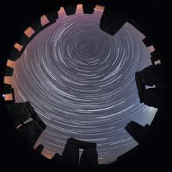
全景天空图像。在一圈形状像门框的石头上方,明亮弯曲的星轨似乎形成了圆圈

石阵与星环,巨石阵上方的星轨,作者:Till Credner,德国

Caption: 国际天文学联合会 OAE 天文摄影比赛星轨类第二名。 天文学即使不是最古老的科学,也是其中之一,因此千百年来与各种文化都有着千丝万缕的联系。这张图片以巨石阵为背景,在某种程度上传达了这种联系。关于天文学家所说的考古天文学遗址,以及它们与天空的联系(如季节、月相等),有很多研究。古今中外的文明对天空中的景象都有自己的看法和解释,这不仅与文化有关,也与人们的日常活动和季节活动有关。通常被称为 "星轨 "的 "同心圆 "是天空视运动的结果,实际上是地球自转的结果。图像中心上方出现的小点是Polaris--北极星。只有北半球的观测者才能看到北极星。北极星的高度可以用来推断观测者的实际纬度。巨石阵位于北纬 51°左右。这张照片摄于世界上最著名的古代遗址之一,它把我们带回了过去,让我们对千年前生活在那里的人们所讲述的故事产生了好奇。
Credit: Till Credner/IAU OAE

License: CC-BY-4.0 Creative Commons 署名 4.0 国际 (CC BY 4.0) icons


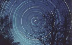
明亮的星轨围绕图像中心形成弧形轨迹,在其前方,一棵树的剪影静静矗立。

半日北极星曝光图,作者:来自意大利的法布里齐奥-梅兰德里

Caption: 国际天文学联合会教育办公室天文摄影比赛星轨类第一名。 这张星轨图展示了夜空中恒星的视运动,这种现象是由地球围绕其极轴自转所导致的。前景中的树木为画面提供了一个固定的参照点,使我们在地球自转的过程中能够感受到运动的相对性。图像中央那条明亮的半圆形轨迹是北极星,它位于北天极附近。可以想象地球位于一个中空的水晶球中心,恒星则镶嵌在这个球面上。当地球绕轴自转时,地球上的观察者看到恒星沿着弧线升起和落下。然而,由于地平线的遮挡,那些离天极较远的恒星无法完整地展现出整个弧形轨迹。北天极(及其对应的南天极)实际上是地球自转轴的延长线在天空中的投影。拍摄这张照片需要摄影师使用长曝光技术,将相机固定在三脚架上,并对准北极星(在北半球)。在南半球,并没有像北极星这样接近天极的恒星,因此要确定南天极的位置,需要借助南十字星座以及指引星(半人马座的α星和β星)。尽管整张照片呈现出淡蓝色调,但它仍然很好地捕捉到了恒星的不同颜色,使我们能够区分不同温度的恒星。高温恒星通常呈现蓝色,而较低温的恒星呈现白色甚至红色。这种颜色变化的原因在于,温度较高的恒星会发出更多短波长(偏蓝)的光,而温度较低的恒星主要辐射长波长(偏红)的光。
Credit: 法布里齐奥-梅兰德里/国际天文学联合会教育办公室

License: CC-BY-4.0 Creative Commons 署名 4.0 国际 (CC BY 4.0) icons


水瓢状的北斗七星,左侧是橙色的北极星。右边是弥漫盘状的仙女座星系

如梦如幻的星空和气流

Caption: 2022年国际天文学联合会天文教育办公室天文摄影大赛获奖作品,类别:天体图案静态图像。 这张壮观的图片展示了2019年8月拍摄的内蒙古沙漠上空夜空中可见的一系列显著星座。左下角的黄色恒星是大角星,它是夜空中最亮的恒星之一,也是牧夫座中最亮的恒星。北斗七星的斗柄指向这颗明亮的恒星,北斗七星也位于牧夫座上方。北斗是中国传统的星座,被视为载有贵族审判者的战车。大角星被视为一个单星星群,名为“角”,它是中国春季超级星座——东方青龙的一部分。北斗的斗柄指向照片顶部的恒星,现在称为北极星。在古代中国,北极附近没有明亮的恒星,因此北极附近的恒星被认为属于紫禁宫星座中的皇帝及其家族。至少在中世纪时期,北极星就被认为是天帝星座的一部分。 这张图片的右上角也可以看到北冕座,尽管并不完整。它在中国被称为 "蟠龙"。它具有独特的半圆形,是现代88个星座中较小的一个,但它的历史可以追溯到至少三四千年前,通过罗马的“皇冠”、希腊的婚礼“花环”和巴比伦的“尊严星群”得以追溯。现代名称在拉丁语中字面意思是“北冕”。 在图片的右上边缘,我们发现了现代仙后座的一部分,在中国古代被认为是“飞廊”和“辅路”。仙后座的W形状被照片的边缘切断了,但其南部和东南部的星座——仙女座和英仙座——清晰可见。我们特别看到了仙女座星系,这是肉眼可见的最远天体。它位于银河系带的最外层边缘,这可能解释了为什么它没有在古代星表中被明确提及,因为它被误认为是银河系的一部分。照片还清晰地展示了银河系中肉眼看起来并不明亮的红色部分,以及由同一分子云形成的疏散星团,即年龄相似的恒星群。这个区域是中国传统天文学中许多大小星群的一部分。
Credit: Likai Lin/IAU OAU

License: CC-BY-4.0 Creative Commons 署名 4.0 国际 (CC BY 4.0) icons


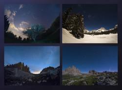
北斗七星,七颗明亮的星星,形状像一个水瓢,在一年四个季节分别观察,每次都呈现不同的角度

四季的北斗

Caption: 2022年国际天文学联合会(IAU)OAE天文摄影比赛静态天体图案类别获奖作品。 随着地球围绕太阳运动,夜空中恒星的位置在一年中也会发生变化。这幅马赛克作品很好地体现了这一点,它是 2020 年全年在意大利威尼托地区拍摄的四季图像,显示了小熊座和大熊座的明显运动。随着地球围绕太阳公转,夜空中恒星的位置在一年中似乎也会发生变化。诞生于意大利威尼托地区的这幅拼接图很好地体现了这一点。这幅作品的拍摄贯穿了2020年的四季,展示了小熊座和大熊座的视运动。 小熊座是北天球的一个星座,包含了北天极。在我们这个时代,北天极的位置由一颗明亮的恒星——北极星来标记。几个世纪以来,北极星一直被用于北半球的导航,因为在大约200年的时间里,北极星几乎一直精确处于北天极的位置。但在中世纪和古代,并没有北极星,北天极位于没有恒星的黑暗区域,因此古希腊人将小熊座视为更容易辨认的大熊座的伙伴。在古希腊人眼中,这两个星座中最亮的几颗恒星也是一辆战车,正如公元前3世纪的阿拉图斯在著名的教诲诗中所写的那样。大熊座最有名的星群由七颗恒星组成,在北半球各地有不同的名称。希腊人认为它是一辆战车,中国人称它为“北斗七星”,古罗马人则将它视作“七牛”。 古希腊人认为,朝着大熊座上方的地平线方向行进,就意味着朝着熊的国度(北欧)前进。如果考虑到七颗亮星附近所有较暗的恒星,就能清楚地辨认出一种动物。他们认为这是一只母熊,因为希腊神话将这种动物与仙女卡利斯托联系在一起,卡利斯托的故事描述了女性的启蒙仪式。 大熊座的得名是出于导航的目的——对希腊人来说,向着大熊座出现的地平线方向行进,就意味着前往熊的国度(北欧)。如果考虑到七颗亮星附近所有较暗的恒星,就能清晰地辨认出一只动物。他们认为这是一只母熊,因为希腊神话将母熊与仙女卡利斯托联系在一起,她的故事描述了女性的启蒙仪式。 左上方是春季傍晚拍摄的照片,左下方是夏季傍晚拍摄的同一片夜空。按照逆时针方向,我们在右下方看到的是秋季的夜空,而右上方最后显示的是冬天的这部分夜空。请注意,小熊座和北斗七星的相对位置并没有变化,但所有恒星似乎都围绕北极星转了一圈——这颗指向正北的恒星位于地球自转轴与天球相交处。 因此,星座在一年中的移动可以看作地球钟或是地球日历,被古代文明用来测量自己在一年中所处的时间,并预测季节的变化。例如,它有助于确定播种和航海的最佳时间,因为风会随着季节而变化。
Credit: Giorgia Hofer/IAU OAE

License: CC-BY-4.0 Creative Commons 署名 4.0 国际 (CC BY 4.0) icons


北斗七星逐渐向左侧地平线下方移动,而右侧则有一颗彗星在天空中升起。

北斗七星和新智彗星 C2020 F3

Caption: 这段延时摄影记录了2020年7月拍摄的三帧画面中标志性的北斗七星的轨迹。影像在意大利的三个地点拍摄:拉瓦雷多三峰(Tre Cime di Lavaredo)奥隆佐迪卡多雷、里特山(Monte Rite)奇比亚纳迪卡多雷,以及拉佐牧场(Casera Razzo)维戈迪卡多雷。这场视觉奥德赛展示了北斗七星的迷人轨迹,并在夜空中绘制出天体画卷。它不仅描绘了这个著名星群的轨迹,还捕捉到2020年7月照亮天空的罕见新智彗星 C/2020 F3 这一非凡的天文事件,为我们的夜空增添了光彩。
Credit: 乔尔贾·霍弗/国际天文学联合会教育办公室 (CC BY 4.0)

License: CC-BY-4.0 Creative Commons 署名 4.0 国际 (CC BY 4.0) icons

Related Diagrams


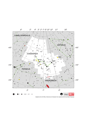
Cassiopeia appears as a double-u shape tilted up at the left end by about 45 degrees

Cassiopeia Constellation Map

Caption: The constellation Cassiopeia along with its bright stars and its surrounding constellations. Cassiopeia is surrounded by (going clockwise from the top):Cepheus, Andromeda, Perseus and Camelopardalis. Cassiopeia is a northern constellation that is visible from all of the northern hemisphere and equatorial regions of the southern hemisphere. It is most visible in the evenings in the northern hemisphere late autumn and southern hemisphere late spring. The open star clusters M52, M103, NGC 457 and NGC 663 all lie in this constellation. These are marked with yellow circles. Two dwarf elliptical galaxies NGC 147 and NGC 185 lie in the southern part of the constellation. These are marked with red ellipses and are gravitationally bound to the larger Andromeda galaxy which lies to the south in the constellation of Andromeda. The y-axis of this diagram is in degrees of declination with north as up and the x-axis is in hours of right ascension with east to the left. The sizes of the stars marked here relate to the star's apparent magnitude, a measure of its apparent brightness. The larger dots represent brighter stars. The Greek letters mark the brightest stars in the constellation. These are ranked by brightness with the brightest star being labeled alpha, the second brightest beta, etc., although this ordering is not always followed exactly. The dotted boundary lines mark the IAU's boundaries of the constellations and the solid green lines mark one of the common forms used to represent the figures of the constellations. Neither the constellation boundaries, nor the lines joining the stars appear on the sky.
Credit: Adapted by the IAU Office of Astronomy for Education from the original by IAU/Sky & Telescope

License: CC-BY-4.0 Creative Commons 署名 4.0 国际 (CC BY 4.0) icons


小熊座像一把小勺,勺柄的末端位于北天极,即北极星所在的位置。

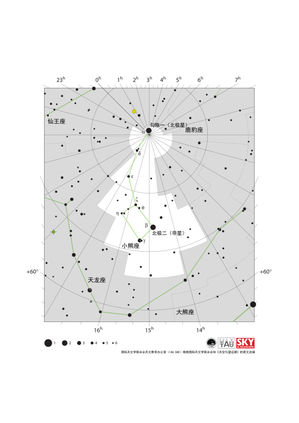
小熊座星图

Caption: 小熊座及其明亮恒星与周边星座示意图。从顶部开始沿顺时针方向,小熊座周边的星座依次为:仙王座、鹿豹座和天龙座。小熊座最亮的星是北极星,它位于北天极。 整个北半球都能看到小熊座,南半球赤道地区也能看到其局部。在北半球温带及寒带地区,小熊座处于恒显圈内,而极其靠近北天极的北极星更是整个北半球的恒显星。小熊座的最佳观测期为北半球夏季与南半球冬季。 本图绘制的是北天极周围的天区。赤经圈在北天极汇合。这些赤经圈的赤经值以小时为单位,标注在上下两侧的横轴上。一些赤纬圈以度为单位,标注在纵轴上。图中标注的恒星大小对应其视星等——衡量天体视亮度的标准,较大的圆点代表着较亮的恒星。图中的希腊字母标注着星座中最亮的恒星。这些恒星按亮度排序,最亮的一般被标记为α星,第二亮的一般为β星,等等,不过这种字母排序并不总是和实际亮度排序完全一致。图中虚线标注的是国际天文学联合会划定的星座边界,绿色实线则是一种常见的星座形象连线。需要注意的是,在实际观测时,这些边界与连线都不会出现在天空中。
Credit: 国际天文学联合会天文教育办公室(IAU OAE)根据国际天文学联合会和《天空与望远镜》的原文改编

License: CC-BY-4.0 Creative Commons 署名 4.0 国际 (CC BY 4.0) icons


大熊座形似一把长柄勺,勺柄朝东、勺斗朝西,几排较暗的恒星向南延伸。

大熊座星图

Caption: 大熊座及其明亮恒星与周边星座示意图。从顶部开始沿顺时针方向,大熊座周边的星座依次为:天龙座、鹿豹座、天猫座、小狮座、狮子座、后发座、猎犬座和牧夫座。大熊座中有着名为“北斗七星”的醒目星群,这也是大熊座最著名的标志。这个醒目的北天星群在全球不同文化中拥有丰富多样的名称。尽管大多数星座和星群中的恒星是互不关联的,它们在天球上投影出的图案其实仅是出于巧合,但北斗七星中的五颗恒星同属“大熊座移动星群”——这些恒星在宇宙中同步运动,很可能在3亿年前形成于同一区域。图中北斗右侧末端的两颗星构成“指极星”,可由它们的连线找到位于小熊座的北极星。 作为北天星座,大熊座在北半球和赤道地区都是可见的。除南极地区外,南半球的部分区域也可观测到大熊座的局部,但南半球温带地区并不都能看到完整的北斗七星。而在北极和北半球大多数温带地区,北斗七星以及大熊座的其他主要部分则处于恒显圈内。大熊座的最佳观测期为北半球春季与南半球秋季。 大熊座的北部有两个易于观测的星系,在图中以红色椭圆标注:旋涡星系M81和可能同为旋涡星系的M82。由于M82的侧方朝向地球,我们难以通过观测确定其结构。行星状星云M97(猫头鹰星云)位于大熊座中央,在图中以叠加了十字符号的绿色圆圈标注。 该图的纵轴为赤纬,横轴为赤经,方向为上北下南左东右西。图中标注的恒星大小对应其视星等——衡量天体视亮度的标准,较大的圆点代表着较亮的恒星。图中的希腊字母标注着星座中最亮的恒星。这些恒星按亮度排序,最亮的一般被标记为α星,第二亮的一般为β星,等等,不过这种字母排序并不总是和实际亮度排序完全一致。图中虚线标注的是国际天文学联合会划定的星座边界,绿色实线则是一种常见的星座形象连线。需要注意的是,在实际观测时,这些边界与连线都不会出现在天空中。
Credit: 国际天文学联合会天文教育办公室(IAU OAE)根据国际天文学联合会和《天空与望远镜》的原文改编

License: CC-BY-4.0 Creative Commons 署名 4.0 国际 (CC BY 4.0) icons


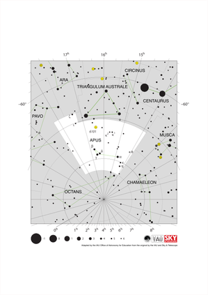
Apus has an northward-pointing isosceles triangle on the east end of an east-west line.

Apus Constellation Map

Caption: The constellation Apus with its bright stars and surrounding constellations. Apus is surrounded by (going clockwise from the top): Triangulum Australe, Circinus, Musca, Chamaeleon, Octans, Pavo and Ara. Apus is a southern constellation lying close to the south celestial pole. As such it is visible at some point in the year from the entire southern hemisphere but is only visible from the most equatorial regions of the northern hemisphere. Apus is circumpolar for all temperate and antarctic regions of the southern hemisphere. It is most visible in the evenings in the northern hemisphere summer and southern hemisphere autumn. The globular cluster NGC 6101 can be found in Apus. It is marked here with a yellow circle with a plus symbol superimposed on it. This diagram maps an area around the south celestial pole. Here lines of constant right ascension converge. The right ascension values (in hours) of these lines are marked on the x-axis above and below the diagram. Lines of constant declination (in degrees) are marked on the y-axis. The sizes of the stars marked here relate to the star's apparent magnitude, a measure of its apparent brightness. The larger dots represent brighter stars. The Greek letters mark the brightest stars in the constellation. These are ranked by brightness with the brightest star being labeled alpha, the second brightest beta, etc., although this ordering is not always followed exactly. The dotted boundary lines mark the IAU's boundaries of the constellations and the solid green lines mark one of the common forms used to represent the figures of the constellations. Neither the constellation boundaries, nor the lines joining the stars appear on the sky.
Credit: Adapted by the IAU Office of Astronomy for Education from the original by IAU/Sky & Telescope

License: CC-BY-4.0 Creative Commons 署名 4.0 国际 (CC BY 4.0) icons


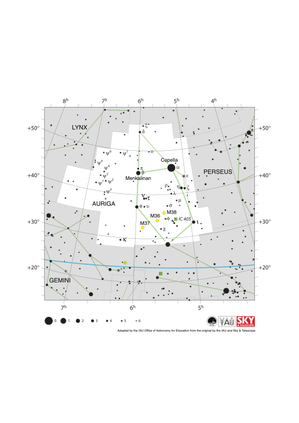
Auriga looks like a head with a pointed hat on. The ecliptic runs East to West below Auriga

Auriga Constellation Map

Caption: The constellation Auriga with its bright stars and surrounding constellations. Auriga is surrounded by (going clockwise from the top): Camelopardalis, Perseus, Taurus, Gemini and Lynx. Capella, the brightest star in Auriga, is the sixth brightest star in the night sky. As a northern constellation, Auriga is visible from the whole of the northern hemisphere at some point in the year. The whole of the constellation is visible to equatorial regions of the southern hemisphere with parts of it visible to temperate southern regions. The whole constellation is circumpolar from arctic regions. The constellation is best viewed in the evening in the late northern hemisphere winter and late southern hemisphere summer. Auriga lies in the plane of the Milky Way and thus hosts a number of open clusters. Of these M36, M37 and M38 are marked on this diagram with yellow circles. IC 405, also known as the flaming star nebula, is marked here with a green square. The y-axis of this diagram is in degrees of declination with north as up and the x-axis is in hours of right ascension with east to the left. The sizes of the stars marked here relate to the star's apparent magnitude, a measure of its apparent brightness. The larger dots represent brighter stars. The Greek letters mark the brightest stars in the constellation. These are ranked by brightness with the brightest star being labeled alpha, the second brightest beta, etc., although this ordering is not always followed exactly. The dotted boundary lines mark the IAU's boundaries of the constellations and the solid green lines mark one of the common forms used to represent the figures of the constellations. The blue line at the bottom of the diagram marks the ecliptic. Neither the constellation boundaries, nor the line marking the ecliptic, nor the lines joining the stars appear on the sky.
Credit: Adapted by the IAU Office of Astronomy for Education from the original by the IAU and Sky & Telescope

License: CC-BY-4.0 Creative Commons 署名 4.0 国际 (CC BY 4.0) icons

Related Activities


Navigation in the Ancient Mediterranean and Beyond

Navigation in the Ancient Mediterranean and Beyond

astroEDU educational activity (links to astroEDU website)
Description: Learn the ancient skill of Celestial Navigation

License: CC-BY-4.0 Creative Commons 署名 4.0 国际 (CC BY 4.0) icons
Tags: History , Geography , Celestial navigation
Age Ranges: 14-16 , 16-19
Education Level: Middle School , Secondary
Areas of Learning: Discussion Groups , Modelling , Social Research
Costs: Low Cost
Duration: 1 hour 30 mins
Group Size: Group
Skills: Analysing and interpreting data , Asking questions , Communicating information , Developing and using models , Planning and carrying out investigations , Using mathematics and computational thinking