Loading...

Glossary term: 晝夜平分點

Description: 晝夜平分點(春分和秋分)是太陽在其年度黃道運行中穿越天球赤道的時刻。該詞源自拉丁語“aequinoctium”,其中“aequus”意為“相等”,“nox”(屬格形式為“noctis”)意為“夜晚”。在晝夜平分點這一天,不僅僅是接近赤道的區域,全球的晝夜長度大致相等。對於地球上的觀察者,太陽在這一天從正東方升起,沿著天球赤道的路徑運行,最後在正西方落下。每年有兩次晝夜平分點,春分大約在3月20日,秋分在9月23日。在3月的春分,太陽看起來開始向北半球移動;而在9月的秋分,太陽看起來則向南半球移動。

Related Terms:


See this term in other languages

Term and definition status: The original definition of this term in English have been approved by a research astronomer and a teacher
The translation of this term and its definition is still awaiting approval

This is an automated transliteration of the simplified Chinese translation of this term

The OAE Multilingual Glossary is a project of the IAU Office of Astronomy for Education (OAE) in collaboration with the IAU Office of Astronomy Outreach (OAO). The terms and definitions were chosen, written and reviewed by a collective effort from the OAE, the OAE Centers and Nodes, the OAE National Astronomy Education Coordinators (NAECs) and other volunteers. You can find a full list of credits here. All glossary terms and their definitions are released under a Creative Commons CC BY-4.0 license and should be credited to "IAU OAE".

Related Media


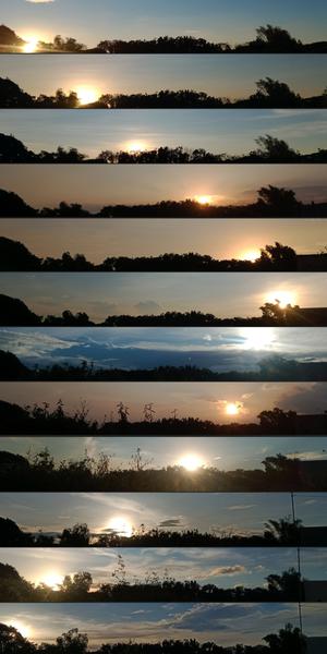
12 幅日落圖片。日落從頂部的左側移動到中部的右側,再回到底部的左側

每月日落的地方

Caption: 這組圖片是在菲律賓布拉干省的聖拉斐爾用智能手機拍攝的,它捕捉到了地球軸向傾斜和環繞太陽運行所導致的日落位置在一年中的變化。從 2022 年 1 月到 12 月,每張圖片都反映了黃昏時分背景和太陽位置的變化。在十月,可以觀察到樹葉的變化和一根電線桿的出現。這組作品是地球與太陽之間的天體舞蹈以及地面自然景觀變化的視覺見證。
Credit: John Paul Pile/IAU OAE (CC BY 4.0)

License: CC-BY-4.0 Creative Commons 姓名標示 4.0 國際 (CC BY 4.0) icons

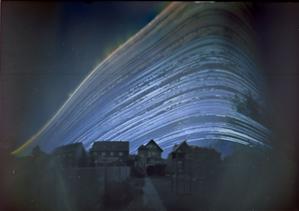
明亮的曲線從左側上升,在右側達到頂峰。線條越往左,峰值越高。

太陽的軌跡

Caption: 這幅令人陶醉的圖片於 2018 年 6 月 21 日至 2018 年 12 月 21 日期間在德國拍攝,是藝術與科學的詩意融合,展現了大自然的韻律和時間的流逝。它合併了六個月內每天不同時間段拍攝的圖片。每條曲線都追蹤了太陽在特定一天內穿越天空的路徑(或弧線)。在這裡,太陽劃過的弧線被投影扭曲,使其看起來像一條曲線。每天劃過天空的弧線位置隨著太陽在天空中的季節性移動而變化。這幅圖片是用一個咖啡罐製成的簡易針孔攝像機拍攝的,它展示了太陽在六個月時間裡的旅程,以及日弧從夏季較高(太陽在天空中的位置較高)逐漸移動到冬至最低位置的過程。太陽路徑上的間隙代表太陽被雲層遮擋的日子或時段。這幅圖片生動地表現了四季的變化,展示了太陽在天空中隨著白天變短或變長而舞動的軌跡。
Credit: Frank Niessen/IAU OAE (CC BY 4.0)

License: CC-BY-4.0 Creative Commons 姓名標示 4.0 國際 (CC BY 4.0) icons

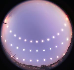
三組太陽在天空中的運動軌跡。最高的軌跡幾乎穿過圖像的中央,而最低的軌跡位於圖像高度的六分之一處。

日至和日分

Caption: 這張引人入勝的照片記錄了在2007年12月21日至2008年6月20日期間,太陽在土耳其布爾薩的冬至(下)、春分(中)以及夏至(上)在天空中運動的軌跡。攝影師使用魚眼鏡頭,在這三天中以固定的時間間隔拍攝太陽從日出到日落的位置,生動展示了一年中晝夜長短的變化。太陽每日在天空中的運行軌跡、正午高度、日出和日落的位置,以及白晝的長度,均由地球自轉軸與其繞太陽軌道的傾斜角度決定。這一系列照片拍攝於布爾薩的一座屋頂,當地的地形偶爾會遮擋地平線,為畫面增添了獨特的地域特徵。照片中的方向以北朝上、以南朝下,這組視覺日記成為中北緯地區居民欣賞太陽運行軌跡變化的精彩呈現。
Credit: 通奇·特澤爾/國際天文學聯合會教育辦公室 (CC BY 4.0)

License: CC-BY-4.0 Creative Commons 姓名標示 4.0 國際 (CC BY 4.0) icons

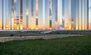
許多日落的圖像拼接在一起。太陽的落下位置從冬天的左側變化到夏天的右側。

西落幅度

Caption: 這張合成照片拍攝于意大利西西里島的 Gatto Corvino 村,展示了從2016年到2017年冬至到夏至期間,太陽在海面上不同位置的落日景象。中心框為正西方。隨著地球繞太陽公轉,太陽的落下(和升起)位置從夏季的正西(東)方向偏北,變化到冬季的正西(東)方向偏南。在春分和秋分時,白晝和黑夜的長度相等,太陽從正東方升起,正西方落下。太陽在地平線上位置的變化是由於地球繞太陽運行時的自轉軸傾斜。在地球的溫帶地區,夏至和冬至時,正午太陽在地平線上的高度角分別達到最高和最低值。
Credit: Marcella Giulia Pace/IAU OAE (CC BY 4.0)

License: CC-BY-4.0 Creative Commons 姓名標示 4.0 國際 (CC BY 4.0) icons
Related Diagrams


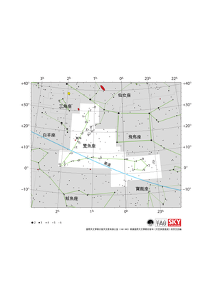
Pisces appears as a SW-pointing v-shape with loops at the end of each line. The ecliptic runs WSW to ENE through Pisces.

Pisces Constellation Map

Caption: The constellation Pisces along with its bright stars and surrounding constellations. Pisces is surrounded by (going clockwise from the top) Andromeda, Pegasus, Aquarius, Cetus, Aries and Triangulum. Pisces lies on the ecliptic (shown here as a blue line), this is the path the Sun appears to take across the sky over the course of a year. The Sun is in Pisces from mid March to mid April. Thus the Sun is in Pisces at the March equinox. At this point the ecliptic crosses the celestial equator. The Sun’s location at the spring equinox is used to set the zero point of the Right Ascension positional coordinate. The other planets of the Solar System can often be found in Pisces. Pisces spans the celestial equator and is thus visible at some time in the year from all of planet Earth. In the most arctic or antarctic regions of the world, some parts of the constellation may not be visible. Pisces is most visible in the evenings in the northern hemisphere autumn and southern hemisphere spring The grand design spiral galaxy M74 is marked on this diagram with a small red circle. The y-axis of this diagram is in degrees of declination and with north as up and the x-axis is in hours of right ascension with east to the left. The sizes of the stars marked here relate to the star's apparent magnitude, a measure of its apparent brightness. The larger dots represent brighter stars. The Greek letters mark the brightest stars in the constellation. These are ranked by brightness with the brightest star being labeled alpha, the second brightest beta, etc., although this ordering is not always followed exactly. The dotted boundary lines mark the IAU's boundaries of the constellations and the solid green lines mark one of the common forms used to represent the figures of the constellations. Neither the constellation boundaries, nor the lines joining the stars appear on the sky.
Credit: Adapted by the IAU Office of Astronomy for Education from the original by IAU/Sky & Telescope

License: CC-BY-4.0 Creative Commons 姓名標示 4.0 國際 (CC BY 4.0) icons