Loading...

Glossary term: 拱極星

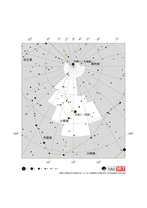
Description: 在地球上的大多數地方,都能在地平線以上一定距離的天空中看到北天極或南天極。對於處於這樣一個位置的觀測者來說,隨著時間的流逝,星星似乎在圍繞著天極旋轉:每顆恆星都在天空中劃出一個圓圈,其中心是地軸指向的天極。在圓圈與觀測者地平線相交的兩點,即東點和西點,該恆星將分別升起和落下。對於距離天極足夠近的恆星,其劃出的圓圈將完全位於地平線之上。我們的觀測者將永遠看不到這些恆星升起或落下。這些永不落下的恆星被稱為拱極星。

哪些恆星是拱極星取決於觀測者的地理緯度和恆星的赤緯——後者是恆星所在位置與天赤道之間的夾角。在北半球,如果一顆恆星的赤緯大於90°減去觀測者的地理緯度,那麼它就是拱極星。在南半球,我們需要考慮到地理南緯和恆星的南赤緯都帶有負號。考慮到這些負號,在南半球,如果一顆恆星的赤緯小於-90°減去觀測者的地理緯度,那麼它就是拱極星。

Related Terms:


See this term in other languages

Term and definition status: The original definition of this term in English have been approved by a research astronomer and a teacher
The translation of this term and its definition is still awaiting approval

This is an automated transliteration of the simplified Chinese translation of this term

The OAE Multilingual Glossary is a project of the IAU Office of Astronomy for Education (OAE) in collaboration with the IAU Office of Astronomy Outreach (OAO). The terms and definitions were chosen, written and reviewed by a collective effort from the OAE, the OAE Centers and Nodes, the OAE National Astronomy Education Coordinators (NAECs) and other volunteers. You can find a full list of credits here. All glossary terms and their definitions are released under a Creative Commons CC BY-4.0 license and should be credited to "IAU OAE".

Related Media


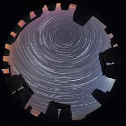
An all-sky image. Above a ring of stones shaped like door-frames, the bright curved paths of star trails seem to form circles

Stone Star Circles, Startrails above Stonehenge, by Till Credner, Germany

Caption: Second place in the IAU OAE Astrophotography Contest, category Star trails. Astronomy is one of the oldest (if not the oldest) of the sciences, and as such has connection to various cultures over millennia. This image in a way conveys this relationship by being contextualised in Stonehenge. There is much research into what astronomers call archeoastronomy sites, and how they connect to the sky (for example, seasons, phases of the moon and much more). Civilizations across time and from all over the world have their own views and interpretations of what they see in the sky, and this has been tied not only to culture but also to the people’s day-to-day and seasonal activities. The “concentric circles” which are often referred to as “star trails”, are the result of the apparent motion of the sky, which is in reality due to the rotation of the Earth on its axis. The small dot appearing towards the top center of the image is Polaris – The North or Pole Star. Polaris is only visible to observers in the Northern latitudes. The height of the Pole Star can be used to infer the observer’s actual latitude. Stonehenge is located at around 51° North. This image is taken from one of the most notable ancient sites in the world, brings us back in time, and makes us wonder about the stories told by the people that lived in that place many millennia ago.
Credit: Till Credner/IAU OAE

License: CC-BY-4.0 Creative Commons 姓名標示 4.0 國際 (CC BY 4.0) icons


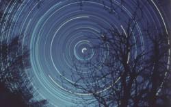
Bright star trails for arcs around the center of the image behind the silhouette of a tree

Half day exposure to the north star, by Fabrizio Melandri, Italy

Caption: First place in the IAU OAE Astrophotography Contest, category Star trails. This star trail image shows the apparent movement of the stars in the night sky, which results from the Earth’s rotation around its polar axis. The trees in the foreground serve as an anchor as we turn with the Earth. The bright white semi-circle in the center of the image is the North (Pole) star – Polaris, which is located very close to the North Celestial Pole. One way to imagine that the Earth is at center of hollow crystal sphere, and the stars are embedded on this sphere, as the Earth spins on its axis, an observer on Earth sees the stars rising and setting, following an arc, because the horizon prevents the observer from the full arc for stars that are further away from the Celestial Pole. The North Celestial Pole (and its opposite the South Celestial Pole) is essentially formed by extending the line of the Earth’s axis. Capturing this image requires the photographer to take a long exposure with the camera on a tripod and pointing towards the Pole Star (North Hemisphere). In the Southern Hemisphere there is no star as close as Polaris is to the Celestial Pole, so the position of the South Celestial Pole is found using the South Cross and Pointer Stars (Alpha and Beta Centauri). Although overall the image has a slight blue tint, it does capture the varying colours of stars, it is easy to distinguish between the higher temperature blue stars and the lower temperature of the whitish stars, and even lower temperature reddish stars. The reason for this variation in colour is because higher temperature stars emit more in shorter wavelengths (bluer), compared to lower temperature stars which emit in longer wavelengths (redder).
Credit: Fabrizio Melandri/IAU OAE

License: CC-BY-4.0 Creative Commons 姓名標示 4.0 國際 (CC BY 4.0) icons


The ladle-shaped Big Dipper with the orange star Arcturus to its left. Right is the diffuse disk-shaped Andromeda galaxy

Dreamlike Starry Sky and Airglow

Caption: Winner in the 2022 IAU OAE Astrophotography Contest, category Still images of celestial patterns.   This spectacular image shows a range of prominent constellations visible in the night sky over the desert of inner Mongolia, taken in August 2019. The yellowish star in the bottom left side is Arcturus, one of the brightest stars in the night sky, and the brightest in the constellation Boötes. The handle of the Big Dipper points towards this bright star and the Dipper is also visible above Boötes. The Northern Dipper (Bei Dou) is a traditional Chinese constellation. It is considered a chariot in which the Judges for Nobility are sitting. Arcturus is considered a single-star asterism, named the Horn, which forms part of the Chinese super-constellation for the spring, the Azure Dragon of the East. The front of the Northern Dipper points towards the star at the top of the photograph which is now called Polaris, the northern Pole Star. In ancient China, there was no bright star at the pole, so the stars in the nearest vicinity of the pole were considered to belong to the emperor and his family in the constellation the Purple Forbidden Palace. At least as early as mediaeval times, Polaris was considered part of the constellation of the Great Emperor of Heaven. Corona Borealis is also visible in the top right corner of this image, although not in its completeness. It is called the Coiled Thong in China. With its characteristic semi-circular shape, this is one of the smaller constellations of the 88 modern ones, but also can be traced back at least three or four millennia through the Roman “Crown”, the Greek wedding “Wreath”, and the Babylonian “Asterism of Dignity”. The modern name literally means “Northern Crown” in Latin. At the upper-right edge of the image, we find the part of the modern constellation Cassiopeia that is considered the Flying Corridor and an Auxiliary Road in ancient China. The W-shape of Cassiopeia is cut off by the edge of the photograph but the constellations to its south and southeast, Andromeda and Perseus, are clearly recognisable. Prominently we see the Andromeda galaxy, the most distant object that is visible to the unaided eye. It is located at the outermost outliers of the band of the Milky Way, which could explain why it has not been mentioned explicitly in ancient star catalogues, as it was mistakenly thought to be part of the Milky Way. The photograph also shows clearly reddish parts of the Milky Way that don’t appear bright to the naked eye, and also open clusters that are formed from the same molecular cloud, i.e., groups of stars with similar ages. This region is part of many big and small asterisms in traditional Chinese uranology.
Credit: Likai Lin/IAU OAE

License: CC-BY-4.0 Creative Commons 姓名標示 4.0 國際 (CC BY 4.0) icons


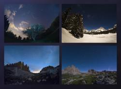
The Big Dipper, seven bright stars shaped like a ladle, viewed in 4 seasons, each time at a different angle

Big Dipper in Four Seasons

Caption: Winner in the 2022 IAU OAE Astrophotography Contest, category Still images of celestial patterns.   As Earth moves around the Sun, the positions of the stars in the night sky appear to change over the course of the year. This is well exemplified in this mosaic, with images taken in all four seasons throughout 2020 in the region of Veneto, Italy, showing the apparent motion of the Ursa Minor and Ursa Major constellations. Ursa Minor, the Little Bear, is a constellation of the northern hemisphere, and it contains the northern celestial pole, in our current epoch marked by a bright star called Polaris or the Pole Star. For centuries Polaris has been used for navigation in the northern hemisphere, as it has been almost at the exact pole position for roughly 200 years. In the Middle Ages and antiquity, there was no pole star; the celestial north pole lay in a dark region and the Greeks considered the “Little She-Bear” as a companion of the “Great She-Bear”, which is more easily recognizable. The brightest stars of these constellations were alternatively also considered as chariots by the Greeks, as written in Aratus’s famous didactic poem from the 3rd century before the common era. The most famous asterism in Ursa Major, composed of seven stars, has different names across the (northern) world. While considered as a chariot by the Greeks, it is “The Northern Dipper” in China, and “The Seven Oxen” for the ancient Romans. It was also the navigational purpose that led to the name The Great She-Bear, Ursa Major; for the Greeks, travelling towards the direction of the horizon above which Ursa Major appears meant moving towards the land of the bears (northern Europe). An animal is clearly recognizable when taking into account all the fainter stars in the vicinity of the seven bright ones. They considered it a female bear because Greek mythology connects this animal with the nymph Callisto, whose story describes the initiation rituals for women. In the top left, we see an image taken on a spring evening, while the image below shows the same portion of the sky on a summer evening. Going counterclockwise, we see the sky during autumn in the bottom right image, while the top right finally shows this portion of the sky in the winter. Note that the relative positions of Ursa Minor and the Big Dipper don’t change, but all stars appear to be moved in a circle around Polaris. This star pointing due north lies at the point where Earth’s rotational axis intersects the celestial sphere. The shift of constellations throughout the year is therefore a globe-clock or a globe-calendar, used by ancient civilizations to measure the year, and to predict the changes of seasons. It helps to establish, for instance, the best time for sowing and sailing as winds change with the seasons.
Credit: Giorgia Hofer/IAU OAE

License: CC-BY-4.0 Creative Commons 姓名標示 4.0 國際 (CC BY 4.0) icons


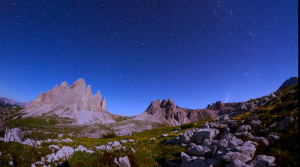
北斗七星逐漸向左側地平線下方移動,而右側則有一顆彗星在天空中升起。

北斗七星和新智彗星 C2020 F3

Caption: 這段延時攝影記錄了2020年7月拍攝的三幀畫面中標誌性的北斗七星的軌跡。影像在意大利的三個地點拍攝:拉瓦雷多三峰(Tre Cime di Lavaredo)奧隆佐迪卡多雷、裡特山(Monte Rite)奇比亞納迪卡多雷,以及拉佐牧場(Casera Razzo)維戈迪卡多雷。這場視覺奧德賽展示了北斗七星的迷人軌跡,並在夜空中繪製出天體畫卷。它不僅描繪了這個著名星群的軌跡,還捕捉到2020年7月照亮天空的罕見新智彗星 C/2020 F3 這一非凡的天文事件,為我們的夜空增添了光彩。
Credit: 喬爾賈·霍弗/國際天文學聯合會教育辦公室 (CC BY 4.0)

License: CC-BY-4.0 Creative Commons 姓名標示 4.0 國際 (CC BY 4.0) icons


The Big Dipper sinks in the sky with the handle sweeping out a larger circle than the bowl of the asterism.

Big Dipper Over the Mono Lake

Caption: The Big Dipper asterism gracefully moves above the otherworldly tufa formations of Mono Lake, California. The time-lapse captures the Big Dipper’s movement across the northern horizon until its inferior conjunction. At Mono Lake’s latitude (+38°), the stars of the Big Dipper remain circumpolar, except for Alkaid. The North Star sits 38° above the horizon, just outside the field of view in the top right. The lunar illumination bathes the landscape in a soft glow, gradually fading as the Moon sets, cloaking the scene in darkness.
Credit: Fabrizio Melandri/IAU OAE (CC BY 4.0)

License: CC-BY-4.0 Creative Commons 姓名標示 4.0 國際 (CC BY 4.0) icons


A traditional Chinese building. Above the streaks of stars form a circular pattern around the north star.

Star Trails of the Forbidden City

Caption: Beneath the celestial ballet of star trails that weave their way across the night sky, the Beijing Forbidden City stands as a testament to ancient celestial connections in this image captured in March 2022. Designed with a cosmic alignment in mind, the palace echoes the orientation of the North Star, also known as Polaris, a celestial anchor that has long guided navigators and symbolised steadiness in the sky. It was believed that the Emperor embodied the earthly representation of this pole star, bridging the realms between heaven and earth. In this harmonious one-hour exposure captured with a smartphone, the streaks of stars trace their nightly journey across the firmament, converging toward the North Star, reflecting the precision of both architectural design and celestial paths.
Credit: Stephanie Ziyi Ye/IAU OAE (CC BY 4.0)

License: CC-BY-4.0 Creative Commons 姓名標示 4.0 國際 (CC BY 4.0) icons

Related Activities


Navigation in the Ancient Mediterranean and Beyond

Navigation in the Ancient Mediterranean and Beyond

astroEDU educational activity (links to astroEDU website)
Description: Learn the ancient skill of Celestial Navigation

License: CC-BY-4.0 Creative Commons 姓名標示 4.0 國際 (CC BY 4.0) icons

Tags: History , Geography , Celestial navigation
Age Ranges: 14-16 , 16-19
Education Level: Middle School , Secondary
Areas of Learning: Discussion Groups , Modelling , Social Research
Costs: Low Cost
Duration: 1 hour 30 mins
Group Size: Group
Skills: Analysing and interpreting data , Asking questions , Communicating information , Developing and using models , Planning and carrying out investigations , Using mathematics and computational thinking