Glossar-Begriff: Polarkreis
Beschreibung: Die Polarkreise sind besondere Breitenkreise auf der Erde. Der Polarkreis bei 66°33′48,8″ N wird als nördlicher Polarkreis und der Polarkreis bei 66°33′48,8″ S als südlicher Polarkreis bezeichnet. Aufgrund der geneigten Rotationsachse der Erde gibt es in Regionen nördlich des nördlichen Polarkreises und südlich des südlichen Polarkreise im Winter "Polarnächte" und im Sommer "Polartage". Während einer Polarnacht steht die Sonne mehr als 24 Stunden lang unter dem Horizont. Diese Zeit der Dunkelheit kann mehrere Monate dauern. Während eines Polartages steht die Sonne mehr als 24 Stunden lang über dem Horizont: Dann kann es mehrere Monate lang taghell sein. Polartage und -nächte sind in der Nähe der Pole am längsten. Polarnächte finden vor und nach der Wintersonnenwende der jeweiligen Polarregion statt, Polartage vor und nach der Sommersonnenwende.
Ähnliche Begriffe:
Dieser Begriff in anderen Sprachen
Begriffs- und Definitionsstatus Die Originaldefinition dieses Begriffes auf Englisch wurden von einem forschenden Astronom und einer Lehrkraft bestätigt Die Übersetzung dieses Begriffs und seiner Definition warten auf Prüfung und Bestätigung
The OAE Multilingual Glossary is a project of the IAU Office of Astronomy for Education (OAE) in collaboration with the IAU Office of Astronomy Outreach (OAO). The terms and definitions were chosen, written and reviewed by a collective effort from the OAE, the OAE Centers and Nodes, the OAE National Astronomy Education Coordinators (NAECs) and other volunteers. You can find a full list of credits here. All glossary terms and their definitions are released under a Creative Commons CC BY-4.0 license and should be credited to "IAU OAE".
Wenn dir ein inhaltlicher oder Übersetzungsfehler in diesem Glossarbegriff oder dieser Definition auffallen, bitte kontaktiere uns.
Auf anderen Sprachen
- Arabisch: الدائرة القطبية
- Englisch: Polar Circle
- Spanisch: Círculo Polar Ártico
- Französisch: Cercle polaire
- Italienisch: Circolo polare
- Koreanisch: 극권
- Marathi: ध्रुवीय वर्तुळ
- Nepali: ध्रुवीय वृत्त
- Brasilianisches Portugiesisch: Círculo Polar
- Vereinfachtes Chinesisch: 极圈
- Traditionelles Chinesisch: 極圈
Ähnliche Medien
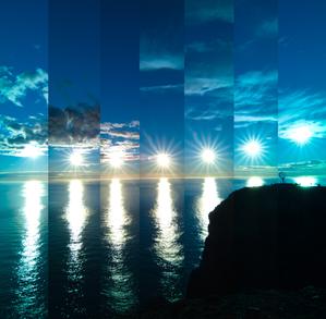
Wenn die Sonne abprallt
Unterschrift: Dieses Bild wurde am Nordkap Norwegens aufgenommen. Aufgrund der geografischen Breite dieses Ortes geht die Sonne in den Sommermonaten von etwa April bis August nie wirklich unter. Dies führt zu dem einzigartigen Schauspiel des kontinuierlichen Tageslichts, das als Polartag bekannt ist. Diese faszinierende Bilderserie aus dem Jahr 2022 zeigt die unaufhaltsame Reise der Sonne über den Horizont alle 30 Minuten. An ihrem tiefsten Punkt am Himmel geht die Sonne nicht unter, sondern scheint am Horizont abzuprallen. Der Globus ganz rechts im Bild steht wie ein Wächter und markiert den nördlichsten Punkt des europäischen Festlands.
Bild: Milos Obert/IAU OAE (CC BY 4.0)
License: CC-BY-4.0 Creative Commons Namensnennung 4.0 International (CC BY 4.0) Symbole
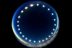
Die Sonnenfinsternis-Uhr – Sonnenfinsternis an einem Polartag
Unterschrift: Das Bild wurde durch die Kombination mehrerer Aufnahmen über einen Zeitraum von 24 Stunden erstellt. Es wurde während der totalen Sonnenfinsternis am 4. Dezember 2021 am Union Gletscher in der Antarktis aufgenommen und zeigt den Tagbogen der Sonne. Es veranschaulicht das einzigartige Phänomen eines Polartages, an dem die Sonne über den Himmel wandert, ohne unterzugehen. An Polartagen herrscht in den Gebieten innerhalb der Polarkreise 24 Stunden lang ununterbrochenes Tageslicht und die Sonne geht über einen längeren Zeitraum nicht unter. Das Bild bietet auch eine seltene Perspektive einer Sonnenfinsternis, bei der der Mond von der Erde aus gesehen zwischen Sonne und Erde vorbeizieht. Die Finsternis ist auf dem untersten Bild der Sonne zu sehen, auf dem der Mond die Sonnenscheibe bedeckt.
Bild: Stephanie Ziyi Ye/IAU OAE (CC BY 4.0)
License: CC-BY-4.0 Creative Commons Namensnennung 4.0 International (CC BY 4.0) Symbole
Ähnliche Diagramme

Latitude and Longitude
Unterschrift: Two views of the Earth, one viewing the Northern Hemisphere, one viewing the Southern Hemisphere. The Earth rotates around its axis, an imaginary line that runs through the Earth from the North Pole to the South Pole. The Equator is an imaginary line that is the same distant from both the North Pole and the South Pole.
The positions of two cities, Rome in the Northern Hemisphere and Sydney in the Southern Hemisphere are marked here with red dots. Arrows indicate the two spherical coordinates latitude and longitude.
Latitude marks the position north or south of the equator. Here we can see Rome has the letter N in its latitude as it is in the Northern Hemisphere and Sydney has the letter S in its latitude as it is in the Southern Hemisphere. Latitude can vary from 90° N at the North Pole to 0° at the Equator to 90° S at the South Pole.
Longitude measures the position around the equator. While the choice of the zero point for latitude as the equator seems obvious, the choice of the zero point for longitude is more subjective. By convention the zero point in longitude is the prime meridian which passes through the Royal Greenwich Observatory in the UK. This is marked here as a solid line originating at the North Pole. Longitude is measured in degrees east or west of the prime meridian. As both Rome and Sydney lie to the east of Greenwich, they have the letter E as part of their longitude. Moving west to east, longitude varies from 180° W on the other side of the world from the prime meridian to 0° on the prime meridian before reaching 180° E again on the other side of world from the prime meridian.
This diagram shows the Earth at the December solstice. Two views are presented, one viewing the Northern Hemisphere and one viewing the Southern Hemisphere about nine hours later. The shaded region shows the night side of the Earth, with the day side being lighter. As it is the December solstice, the Sun appears overhead at the Tropic of Capricorn. This is a line of constant latitude at 23°26′09.3″ S. Six months later, at the June solstice, the Sun will appear to be overhead at the Tropic of Cancer at 23°26′09.3″ N. As the Sun appears over the Tropic of Capricorn more of the Southern Hemisphere is illuminated than the Northern Hemisphere. Indeed below the Antarctic Circle (the Polar Circle around the South Pole) the Sun does not set at this time of year leading to a Polar Day. Conversely, north of the Arctic Circle (the Polar Circle around the North Pole) the Sun does not rise at this time of year, leading to a Polar Night.
Bild: Maria Cristina Fortuna/IAU OAE
License: CC-BY-4.0 Creative Commons Namensnennung 4.0 International (CC BY 4.0) Symbole
Ähnliche Aktivitäten
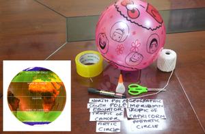
Discover Earth's climate with a balloon
astroEDU educational activity (links to astroEDU website) Description: Discover the secrets of Earth's climate zones with a hands-on experience
License: CC-BY-4.0 Creative Commons Namensnennung 4.0 International (CC BY 4.0) Symbole
Altersgruppen:
8-10
, 10-12
Bildungsniveau:
Middle School
, Primary
Lernbereiche:
Fun activity
, Guided-discovery learning
, Modelling
, Observation based
, Project-based learning
, Social Research
Kosten:
Low Cost
Dauer:
45 mins
Gruppengröße:
Group
Fähigkeiten:
Asking questions
, Constructing explanations
, Developing and using models

