Loading...

Termine del Glossario Coordinate celesti

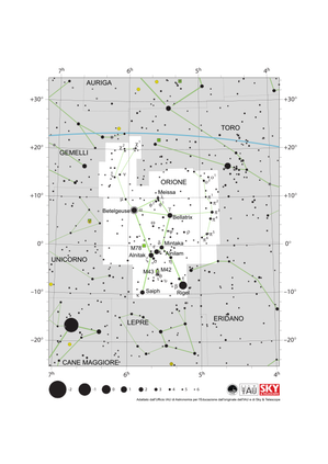
Descrizione Dalla Terra, percepiamo gli oggetti celesti come situati su una sfera, tradizionalmente chiamata sfera celeste. Possiamo descrivere qualsiasi posizione su questa sfera utilizzando due numeri. Ogni metodo per assegnare questi due numeri a una posizione nel cielo è definito sistema di coordinate celesti, e i numeri sono chiamati coordinate (celesti) dell'oggetto. Sulla superficie terrestre, utilizziamo la latitudine e la longitudine geografiche per lo stesso scopo, e in effetti un modo di definire le coordinate celesti deriva da questo: i punti del cielo che si trovano direttamente sopra l'equatore terrestre formano l'equatore celeste, e al punto direttamente sopra una certa posizione sul globo terrestre vengono assegnati dei numeri in modo simile alla latitudine/longitudine del punto base. Gli astronomi utilizzano diversi tipi di sistemi di coordinate, tra cui uno che tiene conto della rotazione giornaliera della Terra; in tal modo le coordinate sono universali e si possono utilizzare da ovunque sulla Terra. Inoltre questo garantisce che le coordinate di una stella, ad esempio, non cambino in modo significativo nel corso di giorni, mesi, o anni.

Termini correlati


Vedi questo termine in altre lingue

status del termine e della definizione La definizione originale di questo termine in inglese é stata approvata da un ricercatore astronomo e da un docente
La traduzione di questo termine e della sua definizione sono state approvate da un ricercatore astronomo e da un docente

Il Glossario Multilingue OAE é un progetto dell'Ufficio IAU per la didatticadell'astronomia (OAE) in collaborazione con l'ufficio IAU OAO per la DivulgazioneAstronomica (OAO). I termini e le definizioni sono stater scelte, scritte eriviste da un impegno collettivo da parte di OAE, i Centri e i Nodi OAE e iCoordinatori Nazionali per la Didattica dell'Astronomia e da altri volontari.Potete trovare una lista completa dei crediti, Tutti i termini del glossarioE le definizioni sono pubblicate su Creative Commons CC BY-4.0 licenza e dovrebbero essere accreditate ad IAU OAE.

Diagrami correlati


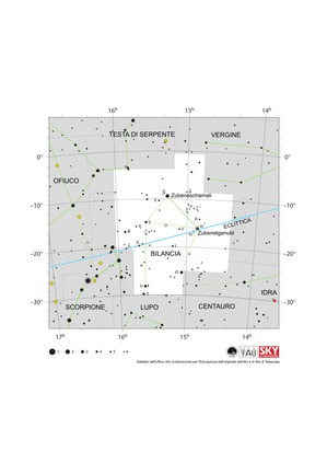
Libra appears as a triangle pointing north (up) with two lines hanging down. It is bisected by the ecliptic running ESE-WNW

Libra Constellation Map

Didascalia: The constellation Libra along with its bright stars and surrounding constellations. Libra is surrounded by (going clockwise from the top) Serpens Caput, Virgo, Hydra, Centaurus, Lupus, Scorpius and Ophiuchus. Libra lies on the ecliptic (shown here as a blue line), this is the path the Sun appears to take across the sky over the course of a year. The Sun is in Libra from late October to late November. The other planets of the Solar System can often be found in Libra. Libra lies just south of the celestial equator and is thus visible at some time in all but the most arctic regions. Libra is most visible in the evenings in the northern hemisphere late spring/early summer and southern hemisphere late autumn/early winter. The y-axis of this diagram is in degrees of declination and with north as up and the x-axis is in hours of right ascension with east to the left. The sizes of the stars marked here relate to the star's apparent magnitude, a measure of its apparent brightness. The larger dots represent brighter stars. The Greek letters mark the brightest stars in the constellation. These are ranked by brightness with the brightest star being labeled alpha, the second brightest beta, etc., although this ordering is not always followed exactly. The dotted boundary lines mark the IAU's boundaries of the constellations and the solid green lines mark one of the common forms used to represent the figures of the constellations. Neither the constellation boundaries, nor the lines joining the stars appear on the sky.
Crediti: Adapted by the IAU Office of Astronomy for Education from the original by IAU/Sky & Telescope

License: CC-BY-4.0 Creative Commons Attribuzione 4.0 Internazionale (CC BY 4.0) icone


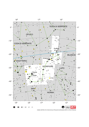
Scorpius appears as a letter T joined to a letter J. The ecliptic runs ESE to WNW and clips one arm of the T

Scorpius Constellation Map

Didascalia: The constellation Scorpius (often commonly called Scorpio) along with its bright stars and surrounding constellations. Scorpius is surrounded by (going clockwise from the top) Ophiuchus, Serpens Caput, Libra, Lupus, Norma, Ara, Corona Australis and Sagittarius. Scorpius’s brightest star Antares appears in the heart of the constellation with the famous tail of Scoprius in the south-east (lower left). Scorpius lies on the ecliptic (shown here as a blue line), this is the path the Sun appears to take across the sky over the course of a year. The Sun only spends a short amount of time in late November in Scorpius. The other planets of the Solar System can often be found in Scorpius. Scorpius lies south of the celestial equator. The whole constellation is not visible from the most arctic regions of the world with parts of Scorpius obscured for observers in northern parts of Asia, Europe and North America. Scorpius is most visible in the evenings in the northern hemisphere summer and southern hemisphere winter. The yellow circles mark the positions of the open clusters M6, M7 & NGC 6231 while the yellow circles with plus signs superimposed on them mark the globular clusters M4 and M80. The y-axis of this diagram is in degrees of declination and with north as up and the x-axis is in hours of right ascension with east to the left. The sizes of the stars marked here relate to the star's apparent magnitude, a measure of its apparent brightness. The larger dots represent brighter stars. The Greek letters mark the brightest stars in the constellation. These are ranked by brightness with the brightest star being labeled alpha, the second brightest beta, etc., although this ordering is not always followed exactly. The circle around Antares indicates that it is a variable star. The dotted boundary lines mark the IAU's boundaries of the constellations and the solid green lines mark one of the common forms used to represent the figures of the constellations. Neither the constellation boundaries, nor the lines joining the stars appear on the sky. The blue line marks the ecliptic, the path the Sun appears to travel across the sky over the course of one year.
Crediti: Adapted by the IAU Office of Astronomy for Education from the original by IAU/Sky & Telescope

License: CC-BY-4.0 Creative Commons Attribuzione 4.0 Internazionale (CC BY 4.0) icone


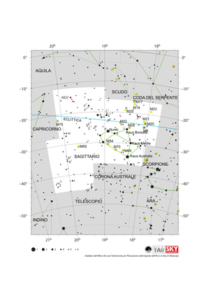
Sagittarius is shaped like a teapot pouring tea south west. The ecliptic runs WSW to ENE at the top of the constellation

Sagittarius Constellation Map

Didascalia: The constellation Sagittarius along with its bright stars and surrounding constellations. Sagittarius is surrounded by (going clockwise from the top) Aquila, Scutum, Serpens Cauda, Ophiuchus, Scorpius, Corona Australis, Telescopium, Microscopium and Capricornus. The brighter stars in Sagittarius form a distinctive teapot shape. Sagittarius lies on the ecliptic (shown here as a blue line), this is the path the Sun appears to take across the sky over the course of a year. The Sun is in Sagittarius from mid December to mid January. The other planets of the Solar System can often be found in Sagittarius. Sagittarius lies south of the celestial equator. The famous teapot asterism is visible for all but the most arctic regions of the world but the most southerly parts of the constellation are not visible in northern parts of Asia, Europe and North America. Sagittarius is most visible in the evenings in the northern hemisphere summer and southern hemisphere winter. The supermassive black hole Sagittarius A* which lies at the center of our Milky Way Galaxy is sits on the western (here right-hand) edge of Sagittarius. Due to it covering an area at the center of our Galaxy, Sagittarius is home to many star clusters including open clusters (marked here with yellow circles) and globular clusters (marked here with yellow circles with + signs superimposed on them). Three nebulae are also marked here with green squares. The y-axis of this diagram is in degrees of declination and with north as up and the x-axis is in hours of right ascension with east to the left. The sizes of the stars marked here relate to the star's apparent magnitude, a measure of its apparent brightness. The larger dots represent brighter stars. The Greek letters mark the brightest stars in the constellation. These are ranked by brightness with the brightest star being labeled alpha, the second brightest beta, etc., although this ordering is not always followed exactly. The dotted boundary lines mark the IAU's boundaries of the constellations and the solid green lines mark one of the common forms used to represent the figures of the constellations. Neither the constellation boundaries, nor the lines joining the stars appear on the sky.
Crediti: Adapted by the IAU Office of Astronomy for Education from the original by IAU/Sky & Telescope

License: CC-BY-4.0 Creative Commons Attribuzione 4.0 Internazionale (CC BY 4.0) icone


Capricornus appears as a downward pointing isosceles triangle. The ecliptic runs through the center from WSW to ENE

Capricornus Constellation Map

Didascalia: The constellation Capricornus (commonly called Capricorn) including its bright stars and surrounding constellations. Capricornus is surrounded by (going clockwise from the top) Aquarius, Aquila, Sagittarius, Microscopium and Piscis Austrinus. Capricornus lies on the ecliptic (shown here as a blue line), this is the path the Sun appears to take across the sky over the course of a year. The Sun is in Capricornus from mid January to mid February. The other planets of the Solar System can often be found in Capricornus. Capricornus lies just south of the celestial equator and is visible to all observers south of the Arctic Circle. Capricornus is most visible in the evenings in the northern hemisphere autumn and southern hemisphere spring. In the south east (lower left on this diagram) of the constellation one can find the globular cluster M30 (shown here as a yellow circle with a plus sign superimposed on it). The y-axis of this diagram is in degrees of declination and with north as up and the x-axis is in hours of right ascension with east to the left. The sizes of the stars marked here relate to the star's apparent magnitude, a measure of its apparent brightness. The larger dots represent brighter stars. The Greek letters mark the brightest stars in the constellation. These are ranked by brightness with the brightest star being labeled alpha, the second brightest beta, etc., although this ordering is not always followed exactly. The dotted boundary lines mark the IAU's boundaries of the constellations and the solid green lines mark one of the common forms used to represent the figures of the constellations. Neither the constellation boundaries, nor the lines joining the stars appear on the sky.
Crediti: Adapted by the IAU Office of Astronomy for Education from the original by IAU/Sky & Telescope

License: CC-BY-4.0 Creative Commons Attribuzione 4.0 Internazionale (CC BY 4.0) icone


Aquarius appears as a sprawling series of connected lines. The ecliptic runs through its center from WSW to ENE.

Aquarius Constellation Map

Didascalia: The constellation Aquarius along with its bright stars and surrounding constellations. Aquarius is surrounded by (going clockwise from the top) Pegasus, Equuleus, Aquila, Capricornus, Piscis Austrinus, Sculptor, Cetus and Pisces. Aquarius lies on the ecliptic (shown here as a blue line), this is the path the Sun appears to take across the sky over the course of a year. The Sun is in Aquarius from mid February to mid March. The other planets of the Solar System can often be found in Aquarius. Aquarius spans the celestial equator and is thus visible at some time in the year from all of planet Earth. In the most arctic or antarctic regions of the world, some parts of the constellation may not be visible. Aquarius is most visible in the evenings in the northern hemisphere autumn and southern hemisphere spring. The yellow circles with plus symbols superimposed on them mark the globular clusters M2 and M72. The green circles superimposed on plus symbols mark the planetary nebulae NGC 7293 (the Helix Nebula) and NGC 7002 (the Saturn Nebula). M73 (marked with an x symbol) is a coincident grouping of stars previously erroneously classified as an open cluster. The y-axis of this diagram is in degrees of declination and with north as up and the x-axis is in hours of right ascension with east to the left. The sizes of the stars marked here relate to the star's apparent magnitude, a measure of its apparent brightness. The larger dots represent brighter stars. The Greek letters mark the brightest stars in the constellation. These are ranked by brightness with the brightest star being labeled alpha, the second brightest beta, etc., although this ordering is not always followed exactly. The dotted boundary lines mark the IAU's boundaries of the constellations and the solid green lines mark one of the common forms used to represent the figures of the constellations. Neither the constellation boundaries, nor the lines joining the stars appear on the sky.
Crediti: Adapted by the IAU Office of Astronomy for Education from the original by IAU/Sky & Telescope

License: CC-BY-4.0 Creative Commons Attribuzione 4.0 Internazionale (CC BY 4.0) icone


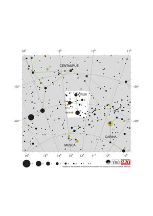
The four bright stars of Crux form a kite shape with the long axis pointing vertically

Crux Constellation Map

Didascalia: The constellation Crux (commonly known as the Southern Cross or Crux Australis) showing its bright stars and surrounding constellations. The Southern Cross is surrounding by (going clockwise from the top) Centaurus, Carina and Musca. The brightest star is alpha Crucis which appears at the bottom of the constellation's famous kite shape. The Southern Cross is visible from southern and equatorial regions of the world. In more southerly parts of the world it is circumpolar so is always above the horizon. In other parts of the southern hemisphere and in equatorial regions it is most visible in the evenings in the southern hemisphere autumn. The yellow circles show the locations of two open clusters, NGC 4755 (known as the Jewel Box) and NGC 4609. The line joining gamma and alpha Crucis (the third and first brightest stars in the Southern Cross) points in the approximate direction of the South Celestial Pole. This has led to the Southern Cross playing an important role in celestial navigation, allowing navigators from different astronomical traditions to find their bearings. The y-axis of this diagram is in degrees of declination and with north as up and the x-axis is in hours of right ascension with east to the left. The sizes of the stars marked here relate to the star's apparent magnitude, a measure of its apparent brightness. The larger dots represent brighter stars. The Greek letters mark the brightest stars in the constellation. These are ranked by brightness with the brightest star being labeled alpha, the second brightest beta, etc., although this ordering is not always followed exactly. The dotted boundary lines mark the IAU's boundaries of the constellations and the solid green lines mark one of the common forms used to represent the figures of the constellations. Neither the constellation boundaries, nor the lines joining the stars appear on the sky.
Crediti: Adapted by the IAU Office of Astronomy for Education from the original by IAU/Sky & Telescope.

License: CC-BY-4.0 Creative Commons Attribuzione 4.0 Internazionale (CC BY 4.0) icone


Pisces appears as a SW-pointing v-shape with loops at the end of each line. The ecliptic runs WSW to ENE through Pisces.

Pisces Constellation Map

Didascalia: The constellation Pisces along with its bright stars and surrounding constellations. Pisces is surrounded by (going clockwise from the top) Andromeda, Pegasus, Aquarius, Cetus, Aries and Triangulum. Pisces lies on the ecliptic (shown here as a blue line), this is the path the Sun appears to take across the sky over the course of a year. The Sun is in Pisces from mid March to mid April. Thus the Sun is in Pisces at the March equinox. At this point the ecliptic crosses the celestial equator. The Sun’s location at the spring equinox is used to set the zero point of the Right Ascension positional coordinate. The other planets of the Solar System can often be found in Pisces. Pisces spans the celestial equator and is thus visible at some time in the year from all of planet Earth. In the most arctic or antarctic regions of the world, some parts of the constellation may not be visible. Pisces is most visible in the evenings in the northern hemisphere autumn and southern hemisphere spring The grand design spiral galaxy M74 is marked on this diagram with a small red circle. The y-axis of this diagram is in degrees of declination and with north as up and the x-axis is in hours of right ascension with east to the left. The sizes of the stars marked here relate to the star's apparent magnitude, a measure of its apparent brightness. The larger dots represent brighter stars. The Greek letters mark the brightest stars in the constellation. These are ranked by brightness with the brightest star being labeled alpha, the second brightest beta, etc., although this ordering is not always followed exactly. The dotted boundary lines mark the IAU's boundaries of the constellations and the solid green lines mark one of the common forms used to represent the figures of the constellations. Neither the constellation boundaries, nor the lines joining the stars appear on the sky.
Crediti: Adapted by the IAU Office of Astronomy for Education from the original by IAU/Sky & Telescope

License: CC-BY-4.0 Creative Commons Attribuzione 4.0 Internazionale (CC BY 4.0) icone


Aries is mostly stars with only a few bright stars in the constellation’s north joined by a curved line. The ecliptic runs WSW to ENE

Aries Constellation Map

Didascalia: The constellation Aries along with its bright stars and surrounding constellations. Aries is surrounded by (going clockwise from the top) Triangulum, Pisces, Cetus, Taurus and Perseus. Aries lies on the ecliptic (shown here as a blue line), this is the path the Sun appears to take across the sky over the course of a year. The Sun is in Aries from mid April to mid May. The other planets of the Solar System can often be found in Aries. Aries lies just north of the celestial equator and is thus visible at some time in the year from all of planet Earth except for the most antarctic regions of the world. Aries is most visible in the evenings in the northern hemisphere winter and southern hemisphere summer. The y-axis of this diagram is in degrees of declination and with north as up and the x-axis is in hours of right ascension with east to the left. The sizes of the stars marked here relate to the star's apparent magnitude, a measure of its apparent brightness. The larger dots represent brighter stars. The Greek letters mark the brightest stars in the constellation. These are ranked by brightness with the brightest star being labeled alpha, the second brightest beta, etc., although this ordering is not always followed exactly. The dotted boundary lines mark the IAU's boundaries of the constellations and the solid green lines mark one of the common forms used to represent the figures of the constellations. Neither the constellation boundaries, nor the lines joining the stars appear on the sky.
Crediti: Adapted by the IAU Office of Astronomy for Education from the original by IAU/Sky & Telescope

License: CC-BY-4.0 Creative Commons Attribuzione 4.0 Internazionale (CC BY 4.0) icone


Taurus appears as a y shape with the open end pointing NE. The ecliptic passes WSW to ENE in Taurus’s northern half

Taurus Constellation Map

Didascalia: The constellation Taurus along with its bright stars and surrounding constellations. Taurus is surrounded by (going clockwise from the top) Perseus, Aries, Cetus, Eridanus, Orion, Gemini and Auriga. Taurus’s brightest star Aldebaran appears in the middle of the constellation. Taurus lies on the ecliptic (shown here as a blue line), this is the path the Sun appears to take across the sky over the course of a year. The Sun is in Taurus from mid May to late June. The other planets of the Solar System can often be found in Taurus. Taurus lies mostly north of the celestial equator with a small part in the celestial southern hemisphere. The whole constellation is visible at some point in the year to whole planet except for the Antarctic and a small region around the North Pole. Taurus is most visible in the evenings in the northern hemisphere winter and southern hemisphere summer. In the eastern part of Taurus we can find the supernova remnant M1 (commonly known as the Crab Nebula), marked here with a green square. In Taurus’s north-east find one of the sky’s most famous open stars clusters M45 (the Pleiades), marked here with a yellow circle. Many of the stars near Aldebaran (but not) Aldebaran are members of another star cluster, the Hyades. However this cluster is close to the solar system so is too dispersed on the sky to have a Messier object designation like the Pleiades has. The y-axis of this diagram is in degrees of declination and with north as up and the x-axis is in hours of right ascension with east to the left. The sizes of the stars marked here relate to the star's apparent magnitude, a measure of its apparent brightness. The larger dots represent brighter stars. The Greek letters mark the brightest stars in the constellation. These are ranked by brightness with the brightest star being labeled alpha, the second brightest beta, etc., although this ordering is not always followed exactly. The dotted boundary lines mark the IAU's boundaries of the constellations and the solid green lines mark one of the common forms used to represent the figures of the constellations. Neither the constellation boundaries, nor the lines joining the stars appear on the sky.
Crediti: Adapted by the IAU Office of Astronomy for Education from the original by IAU/Sky & Telescope

License: CC-BY-4.0 Creative Commons Attribuzione 4.0 Internazionale (CC BY 4.0) icone


Cancer appears as an inverted “Y” on the sky, with its vertex almost exactly on the ecliptic which runs ESE to WNW

Cancer Constellation Map

Didascalia: The zodiac constellation Cancer and its surrounding constellations. Starting from the top of the diagram and going clockwise, these are Lynx, Gemini, Canis Minor, Hydra, Leo and Leo Minor. The ecliptic (shown here as a blue line) passes almost exactly through the middle of the constellation, this is the path the Sun appears to take across the sky over the course of a year. The Sun is in Cancer from late July to mid August. The other planets of the Solar System can often be found in Cancer. Cancer lies just north of the celestial equator and is thus visible at some time in the year from all of planet Earth except for the most antarctic regions of the world. Cancer is most visible in the evenings in the northern hemisphere spring and southern hemisphere autumn. Two star clusters are visible in Cancer: M44, an open cluster often called the Beehive Cluster, and M46, a denser open cluster with about four times more stars than M44. These clusters are indicated by yellow circles with a dotted border on the map. The y-axis of this diagram is in degrees of declination and with north as up and the x-axis is in hours of right ascension with east to the left. The sizes of the stars marked here relate to the star's apparent magnitude, a measure of its apparent brightness. The larger dots represent brighter stars. The Greek letters mark the brightest stars in the constellation. These are ranked by brightness with the brightest star being labelled alpha, the second brightest beta, etc., although this ordering is not always followed exactly. The dotted boundary lines mark the IAU's boundaries of the constellations and the solid green lines mark one of the common forms used to represent the figures of the constellations. Neither the constellation boundaries nor the lines joining the stars appear on the sky.
Crediti: Adapted by the IAU Office of Astronomy for Education from the original by IAU/Sky & Telescope

License: CC-BY-4.0 Creative Commons Attribuzione 4.0 Internazionale (CC BY 4.0) icone


Leo resembles a lion standing on the ecliptic (which runs ESE to WNW) with its nose pointed northwest.

Leo Constellation Map

Didascalia: The zodiac constellation Leo and its surrounding constellations. Starting from the top of the diagram and going clockwise, these are Leo Minor, Cancer, Sextans, Hydra, Crater, Virgo and Ursa Major. The brightest star in Leo, Regulus, lies almost exactly on the ecliptic (shown here as a blue line): the path the Sun appears to take across the sky over the course of a year. The Sun spends the period from mid August to mid September in Leo. The other planets in the Solar System can often be found in Leo. Leo spans the celestial equator and is thus part of it is visible at some time in the year from all of planet Earth with some of the constellation obscured for the most arctic and antarctic regions of the world. Leo is most visible in the evenings in the northern hemisphere spring and southern hemisphere autumn. Several objects can be seen in Leo, including M65 and M66 – two galaxies in the Leo Triplet, a trio of galaxies including NGC 3628, not listed here. In addition, M96, a spiral galaxy, can be seen as a fuzzy object using a small telescope, and Messier 105, an elliptical galaxy. Each of these objects are labelled on the map as red ellipses. The y-axis of this diagram is in degrees of declination and with north as up and the x-axis is in hours of right ascension with east to the left. The sizes of the stars marked here relate to the star's apparent magnitude, a measure of its apparent brightness. The larger dots represent brighter stars. The Greek letters mark the brightest stars in the constellation. These are ranked by brightness with the brightest star being labelled alpha, the second brightest beta, etc., although this ordering is not always followed exactly. The dotted boundary lines mark the IAU's boundaries of the constellations and the solid green lines mark one of the common forms used to represent the figures of the constellations. Neither the constellation boundaries nor the lines joining the stars appear on the sky.
Crediti: Adapted by the IAU Office of Astronomy for Education from the original by IAU/Sky & Telescope

License: CC-BY-4.0 Creative Commons Attribuzione 4.0 Internazionale (CC BY 4.0) icone

Attività correlate


Navigation in the Ancient Mediterranean and Beyond

Navigation in the Ancient Mediterranean and Beyond

astroEDU educational activity (links to astroEDU website)
Description: Learn the ancient skill of Celestial Navigation

License: CC-BY-4.0 Creative Commons Attribuzione 4.0 Internazionale (CC BY 4.0) icone

Etichette: History , Geography , Celestial navigation
Fasce d'età 14-16 , 16-19
Livello di istruzione Middle School , Secondary
Aree di apprendimento Discussion Groups , Modelling , Social Research
Costi: Low Cost
Durata: 1 hour 30 mins
Dimensione del Gruppo: Group
Abilità: Analysing and interpreting data , Asking questions , Communicating information , Developing and using models , Planning and carrying out investigations , Using mathematics and computational thinking