Termine del Glossario Equatore
Descrizione L'equatore è una linea immaginaria che corre intorno alla Terra, equidistante dai poli nord e sud e perpendicolare all'asse di rotazione terrestre. L'equatore rappresenta la linea sulla superficie terrestre più lontana dall'asse di rotazione. Ai poli l'asse di rotazione si interseca con la superficie. Nel sistema di coordinate di latitudine e longitudine sulla superficie terrestre, l'equatore è definito come avente zero gradi di latitudine. L'equatore divide la Terra in un emisfero settentrionale e uno meridionale. I luoghi dell'emisfero settentrionale hanno una latitudine positiva, quelli dell'emisfero meridionale una latitudine negativa.
Termini correlati
Vedi questo termine in altre lingue
status del termine e della definizione La definizione originale di questo termine in inglese é stata approvata da un ricercatore astronomo e da un docente La traduzione di questo termine e della sua definizione sono state approvate da un ricercatore astronomo e da un docente
Il Glossario Multilingue OAE é un progetto dell'Ufficio IAU per la didatticadell'astronomia (OAE) in collaborazione con l'ufficio IAU OAO per la DivulgazioneAstronomica (OAO). I termini e le definizioni sono stater scelte, scritte eriviste da un impegno collettivo da parte di OAE, i Centri e i Nodi OAE e iCoordinatori Nazionali per la Didattica dell'Astronomia e da altri volontari.Potete trovare una lista completa dei crediti, Tutti i termini del glossarioE le definizioni sono pubblicate su Creative Commons CC BY-4.0 licenza e dovrebbero essere accreditate ad IAU OAE.
Se noti un errore di fatto o di traduzione in questo termine del glossario, per favore contattaci.
File multimediali correlati

Il Primo Meridiano
Didascalia: Il meridiano principale è definito come zero gradi di longitudine e va dal Polo Nord attraverso Greenwich a Londra fino al Polo Sud. È rappresentato come una linea rossa luminosa su questa mappa schematica della Terra. La linea orizzontale corrisponde all'equatore, mentre l'antimeridiano stesso forma i bordi esterni a 180 gradi a ovest e ad est.
Crediti: Utente Wikicommons Kmf164
link ai crediti
License: PD Dominio Pubblico icone
Diagrami correlati

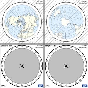
Latitude and Longitude
Didascalia: Two views of the Earth, one viewing the Northern Hemisphere, one viewing the Southern Hemisphere. The Earth rotates around its axis, an imaginary line that runs through the Earth from the North Pole to the South Pole. The Equator is an imaginary line that is the same distant from both the North Pole and the South Pole.
The positions of two cities, Rome in the Northern Hemisphere and Sydney in the Southern Hemisphere are marked here with red dots. Arrows indicate the two spherical coordinates latitude and longitude.
Latitude marks the position north or south of the equator. Here we can see Rome has the letter N in its latitude as it is in the Northern Hemisphere and Sydney has the letter S in its latitude as it is in the Southern Hemisphere. Latitude can vary from 90° N at the North Pole to 0° at the Equator to 90° S at the South Pole.
Longitude measures the position around the equator. While the choice of the zero point for latitude as the equator seems obvious, the choice of the zero point for longitude is more subjective. By convention the zero point in longitude is the prime meridian which passes through the Royal Greenwich Observatory in the UK. This is marked here as a solid line originating at the North Pole. Longitude is measured in degrees east or west of the prime meridian. As both Rome and Sydney lie to the east of Greenwich, they have the letter E as part of their longitude. Moving west to east, longitude varies from 180° W on the other side of the world from the prime meridian to 0° on the prime meridian before reaching 180° E again on the other side of world from the prime meridian.
This diagram shows the Earth at the December solstice. Two views are presented, one viewing the Northern Hemisphere and one viewing the Southern Hemisphere about nine hours later. The shaded region shows the night side of the Earth, with the day side being lighter. As it is the December solstice, the Sun appears overhead at the Tropic of Capricorn. This is a line of constant latitude at 23°26′09.3″ S. Six months later, at the June solstice, the Sun will appear to be overhead at the Tropic of Cancer at 23°26′09.3″ N. As the Sun appears over the Tropic of Capricorn more of the Southern Hemisphere is illuminated than the Northern Hemisphere. Indeed below the Antarctic Circle (the Polar Circle around the South Pole) the Sun does not set at this time of year leading to a Polar Day. Conversely, north of the Arctic Circle (the Polar Circle around the North Pole) the Sun does not rise at this time of year, leading to a Polar Night.
Crediti: Maria Cristina Fortuna/IAU OAE
License: CC-BY-4.0 Creative Commons Attribuzione 4.0 Internazionale (CC BY 4.0) icone
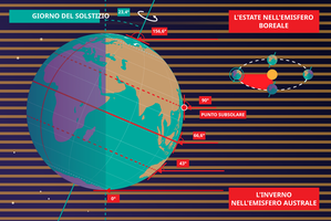
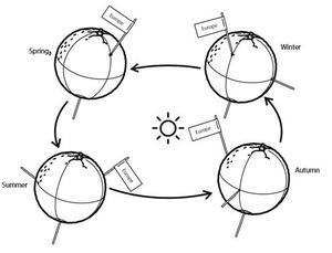
Le stagioni
Didascalia: Questo diagramma mostra la Terra al solstizio di giugno, noto come solstizio d’estate nell’emisfero boreale e solstizio d’inverno nell’emisfero australe. L’asse di rotazione della Terra è inclinato di 23,4° rispetto all’asse dell’orbita terrestre attorno al Sole. Qui vediamo la luce del Sole rappresentata da linee parallele; nel diagramma il Sole si troverebbe molto lontano dal bordo destro. Cinque linee sono contrassegnate da angoli. Queste linee colpiscono la Terra a latitudini particolari. Dall'alto verso il basso, queste linee colpiscono la Terra al Polo Nord, al Tropico del Cancro, all'Equatore, al Tropico del Capricorno e al Circolo Polare Antartico. Le linee sono mostrate mentre colpiscono la Terra alla longitudine dove è attualmente mezzogiorno. Per le ultime quattro linee, gli angoli indicati mostrano l'angolo sopra l'orizzonte (l'altitudine) a cui il Sole appare nel cielo a mezzogiorno locale.
Al solstizio di giugno, il Sole apparirà direttamente sopra la testa a mezzogiorno locale in ogni punto del Tropico del Capricorno. Al contrario, il Sole raggiunge un'altitudine massima di 0° a mezzogiorno locale in ogni punto del Circolo Polare Antartico. Ciò significa che il Sole non sorge mai, e ogni punto a sud del Circolo Polare Antartico vive una lunga Notte Polare. Al contrario, il Sole non tramonta mai in questo giorno a nord del Circolo Polare Artico e le regioni qui vivono un Giorno Polare. Al Polo Nord il Sole rimarrà a un'altitudine costante per tutto il giorno. Questa altitudine sarà l'angolo compreso tra 180° e 156,6° (23,4°).
L'altitudine alla quale appare il Sole è importante poiché definisce quanto siano diffusi i raggi del Sole sulla superficie terrestre. Osservate le linee parallele spesse e sfocate sullo sfondo. Notate come al Tropico del Cancro le linee si intersecano perpendicolarmente con la superficie terrestre e coprono solo una piccola parte di essa. Ora osserva una linea vicino al Tropico del Capricorno e nota che questa si interseca con la Terra con un angolo radente e la linea è estesa, coprendo un'area molto più ampia della superficie terrestre. Ciò significa che una data quantità di luce solare che colpisce il Tropico del Cancro è più concentrata, mentre la stessa quantità di luce che colpisce il Tropico del Capricorno sarebbe più diffusa. Ciò comporta una maggiore quantità di energia per unità di superficie proveniente dal Sole che colpisce il Tropico del Cancro e una minore quantità di energia per unità di superficie che colpisce il Tropico del Capricorno. Ciò significa che al Tropico del Cancro farà più caldo che al Tropico del Capricorno. È quindi estate al Tropico del Cancro e inverno al Tropico del Capricorno.
Sei mesi dopo questa situazione si invertirà e sarà estate al Tropico del Capricorno e inverno al Tropico del Cancro.
Crediti: Maria Cristina Fortuna/IAU OAE
License: CC-BY-4.0 Creative Commons Attribuzione 4.0 Internazionale (CC BY 4.0) icone
Attività correlate
Seasons Around the World
astroEDU educational activity (links to astroEDU website) Description: Demonstrate the seasons on Earth using a model.
License: CC-BY-4.0 Creative Commons Attribuzione 4.0 Internazionale (CC BY 4.0) icone
Etichette:
Hands-on
, Model
Fasce d'età
6-8
, 8-10
, 10-12
Livello di istruzione
Middle School
, Primary
Aree di apprendimento
Modelling
, Structured-inquiry learning
Costi:
Medium Cost
Durata:
45 mins
Dimensione del Gruppo:
Group
Abilità:
Analysing and interpreting data
, Asking questions
, Constructing explanations
, Developing and using models
, Planning and carrying out investigations
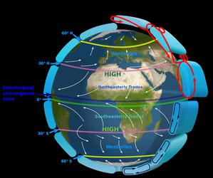
The Intertropical Convergence Zone
astroEDU educational activity (links to astroEDU website) Description: The air circulation system: how are winds created?
License: CC-BY-4.0 Creative Commons Attribuzione 4.0 Internazionale (CC BY 4.0) icone
Etichette:
Climate
, Updraft
, Convection
, Winds
Fasce d'età
12-14
, 14-16
Livello di istruzione
Middle School
Aree di apprendimento
Discussion Groups
, Modelling
, Structured-inquiry learning
Costi:
Medium Cost
Durata:
1 hour
Dimensione del Gruppo:
Group
Abilità:
Communicating information
, Constructing explanations
, Developing and using models
, Engaging in argument from evidence
, Planning and carrying out investigations
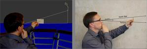
The Quest for Longitude
astroEDU educational activity (links to astroEDU website) Description: How to navigate at sea like an explorer?
License: CC-BY-4.0 Creative Commons Attribuzione 4.0 Internazionale (CC BY 4.0) icone
Etichette:
Clocks
, Geography
, Coordinates
, Celestial navigation
, James Cook
, Exploration
Fasce d'età
14-16
, 16-19
Livello di istruzione
Middle School
, Secondary
Aree di apprendimento
Discussion Groups
, Modelling
, Structured-inquiry learning
Costi:
Low Cost
Durata:
2 hours
Dimensione del Gruppo:
Group
Abilità:
Analysing and interpreting data
, Asking questions
, Communicating information
, Developing and using models
, Planning and carrying out investigations
, Using mathematics and computational thinking
Navigating with the Kamal – Northern Hemisphere
astroEDU educational activity (links to astroEDU website) Description: How did Arabian sailors navigate at sea?
License: CC-BY-4.0 Creative Commons Attribuzione 4.0 Internazionale (CC BY 4.0) icone
Etichette:
History
, Geography
, Coordinates
, Celestial navigation
, Arabia
, Kamal
Fasce d'età
14-16
, 16-19
Livello di istruzione
Middle School
, Secondary
Aree di apprendimento
Modelling
, Structured-inquiry learning
Costi:
Low Cost
Durata:
1 hour 30 mins
Dimensione del Gruppo:
Group
Abilità:
Analysing and interpreting data
, Asking questions
, Communicating information
, Developing and using models
, Planning and carrying out investigations
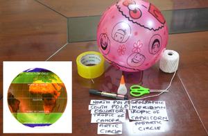
Discover Earth's climate with a balloon
astroEDU educational activity (links to astroEDU website) Description: Discover the secrets of Earth's climate zones with a hands-on experience
License: CC-BY-4.0 Creative Commons Attribuzione 4.0 Internazionale (CC BY 4.0) icone
Fasce d'età
8-10
, 10-12
Livello di istruzione
Middle School
, Primary
Aree di apprendimento
Fun activity
, Guided-discovery learning
, Modelling
, Observation based
, Project-based learning
, Structured-inquiry learning
Costi:
Low Cost
Durata:
45 mins
Dimensione del Gruppo:
Group
Abilità:
Asking questions
, Constructing explanations
, Developing and using models

