Loading...

Glossary term: Equinoxe

Description: L'équinoxe est le moment de l'année où le Soleil, dans son parcours le long de l'écliptique, traverse l'équateur céleste. Le mot est dérivé du latin aequinoctium avec aequus (égal) et nox, noctis (nuit). Le jour de l'équinoxe, les durées du jour et de la nuit sont à peu près égales sur toute la planète, et non pas seulement près de l'équateur. Pour un observateur terrestre, au cours de cette journée, le Soleil se lève presque exactement à l'Est, se déplace le long de l'équateur céleste et se couche presque exactement à l'Ouest. Il y a deux équinoxes par an, l'un autour du 20 mars et l'autre autour du 23 septembre. Lorsque l'équinoxe a lieu en mars, il indique le passage apparent du Soleil de l'hémisphère Sud vers le hémisphère Nord ; lors de l'équinoxe de septembre, le passage apparent du Soleil se fait du Nord au le Sud.

Related Terms:


See this term in other languages

Term and definition status: The original definition of this term in English have been approved by a research astronomer and a teacher
The translation of this term and its definition is still awaiting approval

The OAE Multilingual Glossary is a project of the IAU Office of Astronomy for Education (OAE) in collaboration with the IAU Office of Astronomy Outreach (OAO). The terms and definitions were chosen, written and reviewed by a collective effort from the OAE, the OAE Centers and Nodes, the OAE National Astronomy Education Coordinators (NAECs) and other volunteers. You can find a full list of credits here. All glossary terms and their definitions are released under a Creative Commons CC BY-4.0 license and should be credited to "IAU OAE".

Related Media


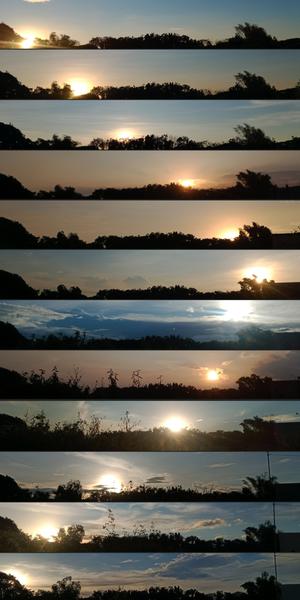
12 images de coucher de Soleil. De janvier à décembre (de haut en bas), le Soleil va du SO au NO, puis reviens vers le SO.

Où le Soleil se couche chaque mois

Caption: Troisième prix du concours d'astrophotographie 2023 de l'UAI OAE, catégorie Images fixes des lieux de lever et de coucher du Soleil au cours de l'année : où le Soleil se couche chaque mois, par John Paul Pile. Prise avec un smartphone depuis San Rafael, Bulacan, Philippines, cette série d'images a remporté le troisième prix dans la catégorie Images fixes des lieux de lever et de coucher du Soleil au cours de l'année. Elles montrent l'évolution de la position du coucher du Soleil au cours de l'année en raison de l'inclinaison de l'axe de rotation de la Terre sur le plan de l'écliptique (plan de l'orbite de la Terre autour du Soleil). De janvier à décembre 2022, chaque image reflète l'évolution de la position du Soleil au crépuscule par rapport au même horizon local. Observez le changement de feuillage et l'apparition d'un poteau électrique en octobre. Cette série d'images est un témoignage visuel de la danse céleste entre la Terre et le Soleil, et des transformations de la nature au fil des saisons.
Credit: John Paul Pile/UAI OAE (CC BY 4.0)

License: CC-BY-4.0 Creative Commons Attribution 4.0 International (CC BY 4.0) icons

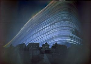
Curved bright lines rise from the left, peaking on the right. The further to the left a line rises, the higher it peaks.

The Path of the Sun

Caption: This enchanting image, captured in Germany between 21 June 2018 and 21 December 2018, is a poetic blend of art and science, showcasing nature's rhythm and the passage of time. It combines images taken at different times of day over the course of six months. Each curve tracks the Sun’s path (or arc) across the sky on a particular day. The sweeping arc of the Sun is distorted here by the projection, making it appear like a curve. The position of the daily arc across the sky changes with the Sun’s seasonal movement in the sky. Captured using a simple pinhole camera fashioned from a coffee can, it shows the Sun's journey over the course of six months, and the gradual shift of the daily arc from the summer, when it is higher in the sky, to its lowest arc at the winter solstice. Gaps in the Sun’s path represent days or times of day when the Sun was obscured by clouds. This image is a vivid testament to the changing seasons, revealing the Sun's dance in the sky as days grow shorter or longer.
Credit: Frank Niessen/IAU OAE (CC BY 4.0)

License: CC-BY-4.0 Creative Commons Attribution 4.0 International (CC BY 4.0) icons

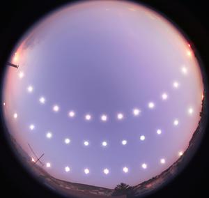
Three paths of the Sun across the sky. The highest almost crosses the middle of the image, the lowest is one sixth of the way

Solstices and Equinox

Caption: This captivating image showcases the journey of the Sun through the sky during the winter solstice (bottom), equinox (middle), and summer solstice (top) in Bursa, Turkey, between 21 December 2007 and 20 June 2008. Using a fisheye lens, the photographer captured the Sun's positions at regular intervals from sunrise to sunset on the three different days, illustrating the changing lengths of day and night throughout the year. The variations in the Sun’s daily path across the sky, its height at midday, and the positions of sunrise and sunset, as well as the length of a day, depend on Earth’s axial tilt relative to its orbit around the Sun. The series was taken from a rooftop in Bursa, where the local terrain adds its own unique touch by occasionally obstructing the horizon. Oriented with north at the top and south at the bottom, this visual diary serves as a stunning representation of the Sun’s path for those residing in mid-northern latitudes.
Credit: Tunç Tezel/IAU OAE (CC BY 4.0)

License: CC-BY-4.0 Creative Commons Attribution 4.0 International (CC BY 4.0) icons

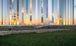
Many images of the sunset in a montage. The Sun’s setting position changes from the left in winter to the right in summer.

Occasive Amplitude

Caption: Captured from Gatto Corvino village in Sicily, this composite showcases the Sun setting at various points over the sea from the winter to the summer solstice (2016–2017). The centre frame marks due west. As Earth orbits the Sun, the position of the setting (and rising) Sun changes from being northward of due west (east) in summer to southward of due west (east) in winter. During the equinoxes — when day and night are of equal length — the Sun rises directly in the east and sets directly in the west. The changing location of the Sun on the horizon is due to Earth’s axial tilt as it orbits the Sun. In temperate regions of Earth, the Sun’s height above the horizon at noon is at its highest and lowest points in the sky on the summer and winter solstices respectively.
Credit: Marcella Giulia Pace/IAU OAE (CC BY 4.0)

License: CC-BY-4.0 Creative Commons Attribution 4.0 International (CC BY 4.0) icons
Related Diagrams


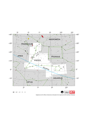
Pisces appears as a SW-pointing v-shape with loops at the end of each line. The ecliptic runs WSW to ENE through Pisces.

Pisces Constellation Map

Caption: The constellation Pisces along with its bright stars and surrounding constellations. Pisces is surrounded by (going clockwise from the top) Andromeda, Pegasus, Aquarius, Cetus, Aries and Triangulum. Pisces lies on the ecliptic (shown here as a blue line), this is the path the Sun appears to take across the sky over the course of a year. The Sun is in Pisces from mid March to mid April. Thus the Sun is in Pisces at the March equinox. At this point the ecliptic crosses the celestial equator. The Sun’s location at the spring equinox is used to set the zero point of the Right Ascension positional coordinate. The other planets of the Solar System can often be found in Pisces. Pisces spans the celestial equator and is thus visible at some time in the year from all of planet Earth. In the most arctic or antarctic regions of the world, some parts of the constellation may not be visible. Pisces is most visible in the evenings in the northern hemisphere autumn and southern hemisphere spring The grand design spiral galaxy M74 is marked on this diagram with a small red circle. The y-axis of this diagram is in degrees of declination and with north as up and the x-axis is in hours of right ascension with east to the left. The sizes of the stars marked here relate to the star's apparent magnitude, a measure of its apparent brightness. The larger dots represent brighter stars. The Greek letters mark the brightest stars in the constellation. These are ranked by brightness with the brightest star being labeled alpha, the second brightest beta, etc., although this ordering is not always followed exactly. The dotted boundary lines mark the IAU's boundaries of the constellations and the solid green lines mark one of the common forms used to represent the figures of the constellations. Neither the constellation boundaries, nor the lines joining the stars appear on the sky.
Credit: Adapted by the IAU Office of Astronomy for Education from the original by IAU/Sky & Telescope

License: CC-BY-4.0 Creative Commons Attribution 4.0 International (CC BY 4.0) icons