Loading...

Glossary term: Étoiles circumpolaires

Description: Dans la plupart des lieux sur la Terre, le pôle Nord céleste ou le pôle Sud céleste est visible dans le ciel à une certaine distance au-dessus de l'horizon. Pour un observateur situé dans un lieu spécifique, les étoiles semblent tourner autour du pôle céleste au fur et à mesure que le temps passe : chaque étoile trace un cercle dans le ciel, le cercle étant centré sur le pôle céleste vers lequel pointe l'axe de la Terre. Aux deux points où le cercle croise l'horizon de l'observateur, l'étoile en question se lève et se couche, respectivement. Pour les étoiles qui sont suffisamment proches du pôle céleste, l'ensemble du cercle tracé est au-dessus de l'horizon. Notre observateur ne voit jamais ces étoiles se lever ou se coucher. Ces étoiles qui ne se couchent jamais sont appelées étoiles circumpolaires.

Pour savoir si une étoile est circumpolaire, il faut prendre en compte la latitude géographique de l'observateur et la déclinaison de l'étoile - cette dernière étant l'angle entre la direction de l'étoile et celle de l'équateur céleste. Dans l'hémisphère nord, une étoile est circumpolaire si sa déclinaison est supérieure à 90° moins la latitude de l'observateur. Dans l'hémisphère sud, il faut tenir compte du fait que les latitudes sur Terre et les valeurs de la déclinaison ont toutes deux un signe négatif. En tenant compte de ces signes, dans l'hémisphère sud, une étoile est circumpolaire si sa déclinaison est inférieure à -90° moins la latitude de l'observateur.

Related Terms:


See this term in other languages

Term and definition status: The original definition of this term in English have been approved by a research astronomer and a teacher
The translation of this term and its definition is still awaiting approval

The OAE Multilingual Glossary is a project of the IAU Office of Astronomy for Education (OAE) in collaboration with the IAU Office of Astronomy Outreach (OAO). The terms and definitions were chosen, written and reviewed by a collective effort from the OAE, the OAE Centers and Nodes, the OAE National Astronomy Education Coordinators (NAECs) and other volunteers. You can find a full list of credits here. All glossary terms and their definitions are released under a Creative Commons CC BY-4.0 license and should be credited to "IAU OAE".

If you notice a factual or translation error in this glossary term or definition then please get in touch.

Related Media


An all-sky image. Above a ring of stones shaped like door-frames, the bright curved paths of star trails seem to form circles

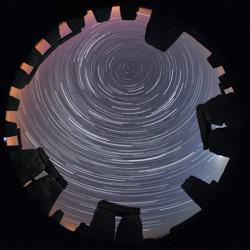
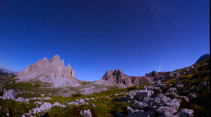
Stone Star Circles, Startrails above Stonehenge, by Till Credner, Germany

Caption: Second place in the IAU OAE Astrophotography Contest, category Star trails. Astronomy is one of the oldest (if not the oldest) of the sciences, and as such has connection to various cultures over millennia. This image in a way conveys this relationship by being contextualised in Stonehenge. There is much research into what astronomers call archeoastronomy sites, and how they connect to the sky (for example, seasons, phases of the moon and much more). Civilizations across time and from all over the world have their own views and interpretations of what they see in the sky, and this has been tied not only to culture but also to the people’s day-to-day and seasonal activities. The “concentric circles” which are often referred to as “star trails”, are the result of the apparent motion of the sky, which is in reality due to the rotation of the Earth on its axis. The small dot appearing towards the top center of the image is Polaris – The North or Pole Star. Polaris is only visible to observers in the Northern latitudes. The height of the Pole Star can be used to infer the observer’s actual latitude. Stonehenge is located at around 51° North. This image is taken from one of the most notable ancient sites in the world, brings us back in time, and makes us wonder about the stories told by the people that lived in that place many millennia ago.
Credit: Till Credner/IAU OAE

License: CC-BY-4.0 Creative Commons Attribution 4.0 International (CC BY 4.0) icons


Traînées d'étoiles brillantes en arc autour du centre de l'image, derrière la silhouette d'un arbre.

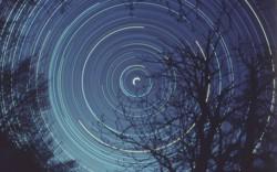
Exposition d'une demi-journée de l'étoile polaire, par Fabrizio Melandri, Italie

Caption: Premier prix du concours d'astrophotographie de l'UAI OAE, catégorie Traînées d'étoiles. Cette image de la traînée d'étoiles montre le mouvement apparent des étoiles dans le ciel nocturne, qui résulte de la rotation de la Terre autour de son axe polaire. Les arbres au premier plan servent de point d'ancrage lorsque nous tournons avec la Terre. Le demi-cercle blanc brillant au centre de l'image est l'étoile polaire nord - Polaris, qui est située très près du Pôle Nord Céleste. On peut imaginer que la Terre est au centre d'une sphère de cristal creuse, et que les étoiles sont incrustées dans cette sphère. À mesure que la Terre tourne sur son axe, un observateur sur Terre voit les étoiles se lever et se coucher, suivant un arc, car l'horizon empêche l'observateur de voir l'arc complet pour les étoiles qui sont plus éloignées du pôle céleste. Le Pôle Céleste Nord (et son opposé le Pôle Céleste Sud) est essentiellement formé en prolongeant la ligne de l'axe de la Terre. Pour capturer cette image, le photographe doit prendre une longue exposition avec l'appareil photo sur un trépied et pointer vers l'étoile polaire (Hémisphère Nord). Dans l'Hémisphère Sud, aucune étoile n'est aussi proche du Pôle Céleste que Polaris. La position du Pôle Céleste Sud est donc déterminée à l'aide de la Croix du Sud et des étoiles pointeurs (Alpha et Beta Centauri). Bien que l'image ait une légère teinte bleue, elle capture les différentes couleurs des étoiles. Il est facile de distinguer les étoiles bleues à haute température des étoiles blanchâtres à plus basse température, et même des étoiles rougeâtres à plus basse température. Cette variation de couleur s'explique par le fait que les étoiles à température élevée émettent davantage dans des longueurs d'onde plus courtes (plus bleues) que les étoiles à température plus basse qui émettent dans des longueurs d'onde plus longues (plus rouges).
Credit: Fabrizio Melandri/IAU OAE

License: CC-BY-4.0 Creative Commons Attribution 4.0 International (CC BY 4.0) icons


The ladle-shaped Big Dipper with the orange star Arcturus to its left. Right is the diffuse disk-shaped Andromeda galaxy

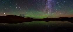
Dreamlike Starry Sky and Airglow

Caption: Winner in the 2022 IAU OAE Astrophotography Contest, category Still images of celestial patterns.   This spectacular image shows a range of prominent constellations visible in the night sky over the desert of inner Mongolia, taken in August 2019. The yellowish star in the bottom left side is Arcturus, one of the brightest stars in the night sky, and the brightest in the constellation Boötes. The handle of the Big Dipper points towards this bright star and the Dipper is also visible above Boötes. The Northern Dipper (Bei Dou) is a traditional Chinese constellation. It is considered a chariot in which the Judges for Nobility are sitting. Arcturus is considered a single-star asterism, named the Horn, which forms part of the Chinese super-constellation for the spring, the Azure Dragon of the East. The front of the Northern Dipper points towards the star at the top of the photograph which is now called Polaris, the northern Pole Star. In ancient China, there was no bright star at the pole, so the stars in the nearest vicinity of the pole were considered to belong to the emperor and his family in the constellation the Purple Forbidden Palace. At least as early as mediaeval times, Polaris was considered part of the constellation of the Great Emperor of Heaven. Corona Borealis is also visible in the top right corner of this image, although not in its completeness. It is called the Coiled Thong in China. With its characteristic semi-circular shape, this is one of the smaller constellations of the 88 modern ones, but also can be traced back at least three or four millennia through the Roman “Crown”, the Greek wedding “Wreath”, and the Babylonian “Asterism of Dignity”. The modern name literally means “Northern Crown” in Latin. At the upper-right edge of the image, we find the part of the modern constellation Cassiopeia that is considered the Flying Corridor and an Auxiliary Road in ancient China. The W-shape of Cassiopeia is cut off by the edge of the photograph but the constellations to its south and southeast, Andromeda and Perseus, are clearly recognisable. Prominently we see the Andromeda galaxy, the most distant object that is visible to the unaided eye. It is located at the outermost outliers of the band of the Milky Way, which could explain why it has not been mentioned explicitly in ancient star catalogues, as it was mistakenly thought to be part of the Milky Way. The photograph also shows clearly reddish parts of the Milky Way that don’t appear bright to the naked eye, and also open clusters that are formed from the same molecular cloud, i.e., groups of stars with similar ages. This region is part of many big and small asterisms in traditional Chinese uranology.
Credit: Likai Lin/IAU OAE

License: CC-BY-4.0 Creative Commons Attribution 4.0 International (CC BY 4.0) icons


La Grande Ourse, sept étoiles brillantes en forme de louche, vue en 4 saisons, à chaque fois sous un angle différent.

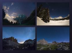
La Grande Ourse aux quatre saisons

Caption: Gagnant du concours d'astrophotographie 2022 de l'IAU OAE, catégorie Images fixes de motifs célestes. La Terre se déplaçant autour du Soleil, la position des étoiles dans le ciel nocturne semble changer au cours de l'année. Ce phénomène est bien illustré par cette mosaïque, dont les images ont été prises au cours des quatre saisons de l'année 2020 dans la région de la Vénétie, en Italie, et qui montre le mouvement apparent des constellations Ursa Minor et Ursa Major. Ursa Minor, la Petite Ourse, est une constellation de l'hémisphère nord. Elle contient le pôle céleste nord, marqué à notre époque par une étoile brillante appelée Polaris ou Étoile Polaire. Pendant des siècles, Polaris a été utilisée pour la navigation dans l'hémisphère nord, car elle se trouve presque à la position exacte du pôle depuis environ 200 ans. Au Moyen Âge et dans l'Antiquité, il n'y avait pas d'étoile polaire ; le pôle nord céleste se trouvait dans une région sombre et les Grecs considéraient la "Petite Ourse" comme une compagne de la "Grande Ourse", qui est plus facilement reconnaissable. Les étoiles les plus brillantes de ces constellations étaient également considérées comme des chars par les Grecs, comme l'indique le célèbre poème didactique d'Aratus datant du IIIe siècle avant l'ère commune. L'astérisme le plus célèbre de la Grande Ourse, composé de sept étoiles, porte différents noms dans le monde (nordique). Alors que les Grecs le considéraient comme un char, il est appelé "L'Ourse du Nord" en Chine et "Les Sept Bœufs" par les anciens Romains. Pour les Grecs, voyager dans la direction de l'horizon au-dessus duquel apparaît Ursa Major signifiait se diriger vers le pays des ours (l'Europe du Nord). Un animal est clairement reconnaissable si l'on tient compte de toutes les étoiles plus faibles qui se trouvent à proximité des sept étoiles brillantes. Ils ont considéré qu'il s'agissait d'une ourse femelle car la mythologie grecque associe cet animal à la nymphe Callisto, dont l'histoire décrit les rituels d'initiation des femmes. En haut à gauche, nous voyons une image prise un soir de printemps, tandis que l'image ci-dessous montre la même portion du ciel un soir d'été. Dans le sens inverse des aiguilles d'une montre, nous voyons le ciel en automne dans l'image en bas à droite, tandis que l'image en haut à droite montre finalement cette portion du ciel en hiver. Notez que les positions relatives d'Ursa Minor et de la Grande Ourse ne changent pas, mais que toutes les étoiles semblent être déplacées dans un cercle autour de Polaris. Cette étoile pointant plein nord se trouve au point d'intersection de l'axe de rotation de la Terre et de la sphère céleste. Le déplacement des constellations au cours de l'année constitue donc une horloge ou un calendrier planétaire, utilisé par les civilisations anciennes pour mesurer l'année et prédire les changements de saison. Il permet de déterminer, par exemple, le meilleur moment pour semer et naviguer, car les vents changent avec les saisons.
Credit: Giorgia Hofer/IAU OAE

License: CC-BY-4.0 Creative Commons Attribution 4.0 International (CC BY 4.0) icons


The Big Dipper drifts lower towards the horizon on the left, on the right a comet rises in the sky.

Big Dipper and Comet Neowise C2020 F3

Caption: This time-lapse documents the trajectory of the iconic Big Dipper across three frames taken in July 2020. Captured from three locations in Italy, Tre Cime di Lavaredo Auronzo di Cadore, Monte Rite, Cibiana di Cadore, and Casera Razzo, Vigo di Cadore, this visual odyssey showcases the captivating journey of the Big Dipper with the addition of trails of stars painting a celestial canvas. It not only traces the path of this renowned asterism but also features the rare appearance of comet Neowise C/2020 F3, an extraordinary event that graced our skies during July 2020.
Credit: Giorgia Hofer/IAU OAE (CC BY 4.0)

License: CC-BY-4.0 Creative Commons Attribution 4.0 International (CC BY 4.0) icons

Related Diagrams


Cassiopeia appears as a double-u shape tilted up at the left end by about 45 degrees

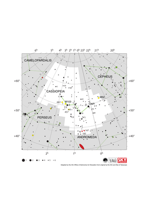
Cassiopeia Constellation Map

Caption: The constellation Cassiopeia along with its bright stars and its surrounding constellations. Cassiopeia is surrounded by (going clockwise from the top):Cepheus, Andromeda, Perseus and Camelopardalis. Cassiopeia is a northern constellation that is visible from all of the northern hemisphere and equatorial regions of the southern hemisphere. It is most visible in the evenings in the northern hemisphere late autumn and southern hemisphere late spring. The open star clusters M52, M103, NGC 457 and NGC 663 all lie in this constellation. These are marked with yellow circles. Two dwarf elliptical galaxies NGC 147 and NGC 185 lie in the southern part of the constellation. These are marked with red ellipses and are gravitationally bound to the larger Andromeda galaxy which lies to the south in the constellation of Andromeda. The y-axis of this diagram is in degrees of declination with north as up and the x-axis is in hours of right ascension with east to the left. The sizes of the stars marked here relate to the star's apparent magnitude, a measure of its apparent brightness. The larger dots represent brighter stars. The Greek letters mark the brightest stars in the constellation. These are ranked by brightness with the brightest star being labeled alpha, the second brightest beta, etc., although this ordering is not always followed exactly. The dotted boundary lines mark the IAU's boundaries of the constellations and the solid green lines mark one of the common forms used to represent the figures of the constellations. Neither the constellation boundaries, nor the lines joining the stars appear on the sky.
Credit: Adapted by the IAU Office of Astronomy for Education from the original by IAU/Sky & Telescope

License: CC-BY-4.0 Creative Commons Attribution 4.0 International (CC BY 4.0) icons


Ursa Minor appears as a small ladle with the end of the handle, the location of Polaris, at the north pole

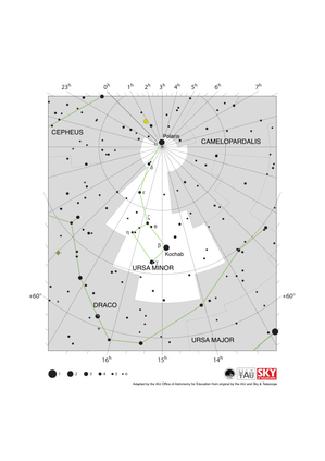
Ursa Minor Constellation Map

Caption: The constellation Ursa Minor along with its bright stars and its surrounding constellations. Ursa Minor is surrounded by (going clockwise from the top): Cephus, Camelopardalis and Draco. Ursa Minor is notable as its brightest star, Polaris is the northern pole star. Ursa Minor is visible from the entire northern hemisphere with some parts of the constellation being visible from equatorial regions of the southern hemisphere. It is also circumpolar for temperate and arctic regions of the northern hemisphere. Polaris, lying very close the north celestial pole is circumpolar for the whole of the northern hemisphere. The constellation is most visible in the evenings in the northern hemisphere summer and southern hemisphere winter. This diagram maps an area around the north celestial pole. Here lines of constant right ascension converge. The right ascension values (in hours) of these lines are marked on the x-axis above and below the diagram. Some of the lines of constant declination (in degrees) are marked on the y-axis. The sizes of the stars marked here relate to the star's apparent magnitude, a measure of its apparent brightness. The larger dots represent brighter stars. The Greek letters mark the brightest stars in the constellation. These are ranked by brightness with the brightest star being labeled alpha, the second brightest beta, etc., although this ordering is not always followed exactly. The dotted boundary lines mark the IAU's boundaries of the constellations and the solid green lines mark one of the common forms used to represent the figures of the constellations. Neither the constellation boundaries, nor the lines joining the stars appear on the sky.
Credit: Adapted by the IAU Office of Astronomy for Education from the original by IAU/Sky & Telescope

License: CC-BY-4.0 Creative Commons Attribution 4.0 International (CC BY 4.0) icons


Ursa Major appears as a ladle with the handle to the east & the cup to the west. Lines of fainter stars extend to the south

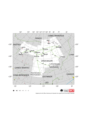
Ursa Major Constellation Map

Caption: The constellation Ursa Major along with its bright stars and its surrounding constellations. Ursa Major is surrounded by (going clockwise from the top): Draco, Camelopardalis, Lynx, Leo Minor, Leo, Coma Berenices, Canes Venatici and Boötes. Ursa Major is famous for the prominent asterism often known in English as the Big Dipper or the Plough. This prominent northern asterism has a wide variety of names from cultures across the world. While most constellations and asterisms are made up of unrelated stars that randomly appear close together on the sky, five of the stars in the Big Dipper are part of the Ursa Major Moving Group, a group of stars moving through space together that likely formed in the same location 300 million years ago. The two stars on the right-hand end of the Big Dipper on this diagram form a pair of pointer stars that can be used to locate Polaris, the northern pole star which lies in the constellation of Ursa Minor. Ursa Major is a northern constellation and is visible from northern and equatorial regions. Parts of the constellation are visible from all but the most antarctic parts of the southern hemisphere but not all temperate regions of the southern hemisphere can see all of the Big Dipper. Conversely the Big Dipper and much of the rest of the constellation are circumpolar in arctic and many temperate regions of the northern hemisphere. Ursa Major is most visible in the evening in the northern hemisphere spring and southern hemisphere autumn. Two prominent galaxies appear in the northern part of this constellation, the spiral galaxy M81 and M82, a possible spiral galaxy whose structure is difficult to observe from the Earth as it appears edge-on. Both are shown here as red ellipses. The planetary nebula M97 (the Owl Nebula) lies in the middle of the constellation and is marked by a green circle superimposed on a plus symbol. The y-axis of this diagram is in degrees of declination with north as up and the x-axis is in hours of right ascension with east to the left. The sizes of the stars marked here relate to the star's apparent magnitude, a measure of its apparent brightness. The larger dots represent brighter stars. The Greek letters mark the brightest stars in the constellation. These are ranked by brightness with the brightest star being labeled alpha, the second brightest beta, etc., although this ordering is not always followed exactly. The dotted boundary lines mark the IAU's boundaries of the constellations and the solid green lines mark one of the common forms used to represent the figures of the constellations. Neither the constellation boundaries, nor the lines joining the stars appear on the sky.
Credit: Adapted by the IAU Office of Astronomy for Education from the original by IAU/Sky & Telescope

License: CC-BY-4.0 Creative Commons Attribution 4.0 International (CC BY 4.0) icons


Apus has an northward-pointing isosceles triangle on the east end of an east-west line.

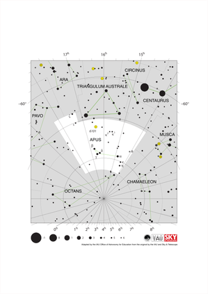
Apus Constellation Map

Caption: The constellation Apus with its bright stars and surrounding constellations. Apus is surrounded by (going clockwise from the top): Triangulum Australe, Circinus, Musca, Chamaeleon, Octans, Pavo and Ara. Apus is a southern constellation lying close to the south celestial pole. As such it is visible at some point in the year from the entire southern hemisphere but is only visible from the most equatorial regions of the northern hemisphere. Apus is circumpolar for all temperate and antarctic regions of the southern hemisphere. It is most visible in the evenings in the northern hemisphere summer and southern hemisphere autumn. The globular cluster NGC 6101 can be found in Apus. It is marked here with a yellow circle with a plus symbol superimposed on it. This diagram maps an area around the south celestial pole. Here lines of constant right ascension converge. The right ascension values (in hours) of these lines are marked on the x-axis above and below the diagram. Lines of constant declination (in degrees) are marked on the y-axis. The sizes of the stars marked here relate to the star's apparent magnitude, a measure of its apparent brightness. The larger dots represent brighter stars. The Greek letters mark the brightest stars in the constellation. These are ranked by brightness with the brightest star being labeled alpha, the second brightest beta, etc., although this ordering is not always followed exactly. The dotted boundary lines mark the IAU's boundaries of the constellations and the solid green lines mark one of the common forms used to represent the figures of the constellations. Neither the constellation boundaries, nor the lines joining the stars appear on the sky.
Credit: Adapted by the IAU Office of Astronomy for Education from the original by IAU/Sky & Telescope

License: CC-BY-4.0 Creative Commons Attribution 4.0 International (CC BY 4.0) icons


Auriga looks like a head with a pointed hat on. The ecliptic runs East to West below Auriga

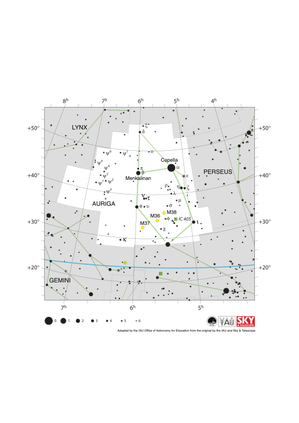
Auriga Constellation Map

Caption: The constellation Auriga with its bright stars and surrounding constellations. Auriga is surrounded by (going clockwise from the top): Camelopardalis, Perseus, Taurus, Gemini and Lynx. Capella, the brightest star in Auriga, is the sixth brightest star in the night sky. As a northern constellation, Auriga is visible from the whole of the northern hemisphere at some point in the year. The whole of the constellation is visible to equatorial regions of the southern hemisphere with parts of it visible to temperate southern regions. The whole constellation is circumpolar from arctic regions. The constellation is best viewed in the evening in the late northern hemisphere winter and late southern hemisphere summer. Auriga lies in the plane of the Milky Way and thus hosts a number of open clusters. Of these M36, M37 and M38 are marked on this diagram with yellow circles. IC 405, also known as the flaming star nebula, is marked here with a green square. The y-axis of this diagram is in degrees of declination with north as up and the x-axis is in hours of right ascension with east to the left. The sizes of the stars marked here relate to the star's apparent magnitude, a measure of its apparent brightness. The larger dots represent brighter stars. The Greek letters mark the brightest stars in the constellation. These are ranked by brightness with the brightest star being labeled alpha, the second brightest beta, etc., although this ordering is not always followed exactly. The dotted boundary lines mark the IAU's boundaries of the constellations and the solid green lines mark one of the common forms used to represent the figures of the constellations. The blue line at the bottom of the diagram marks the ecliptic. Neither the constellation boundaries, nor the line marking the ecliptic, nor the lines joining the stars appear on the sky.
Credit: Adapted by the IAU Office of Astronomy for Education from the original by the IAU and Sky & Telescope

License: CC-BY-4.0 Creative Commons Attribution 4.0 International (CC BY 4.0) icons

Related Activities


Navigation in the Ancient Mediterranean and Beyond

Navigation in the Ancient Mediterranean and Beyond

astroEDU educational activity (links to astroEDU website)
Description: Learn the ancient skill of Celestial Navigation

License: CC-BY-4.0 Creative Commons Attribution 4.0 International (CC BY 4.0) icons
Tags: History , Geography , Celestial navigation
Age Ranges: 14-16 , 16-19
Education Level: Middle School , Secondary
Areas of Learning: Discussion Groups , Modelling , Social Research
Costs: Low Cost
Duration: 1 hour 30 mins
Group Size: Group
Skills: Analysing and interpreting data , Asking questions , Communicating information , Developing and using models , Planning and carrying out investigations , Using mathematics and computational thinking