Terme du glossaire : Latitude
Description : La Terre est une sphère. Pour définir les lieux sur la Terre, deux séries de lignes imaginaires sont tracées sur la surface de la sphère : Les lignes de latitude sont des cercles qui font le tour de la Terre parallèlement à l'équateur. La latitude est mesurée par un angle. Ainsi, l'équateur a une latitude de 0 degré. Les latitudes de l'hémisphère nord sont positives, celles de l'hémisphère sud sont négatives. Les pôles Nord et Sud ont les latitudes les plus élevées en valeur absolue. Le pôle Nord se situe à +90 degrés et le pôle Sud à -90 degrés. Les pôles sont également traversés par des lignes qui décrivent de grands cercles, perpendiculaires à l'équateur. Ce sont les lignes de longitude.
Termes associés :
Voir ce terme dans d'autres langues
Statut du terme et de sa définition : La définition initiale de ce terme en anglais a été aprouvée par un·e spécialiste de la recherche en astronomie et un·e spécialiste de l’éducation La traduction de ce terme et de sa définition ont été aprouvées par un·e spécialiste de la recherche en astronomie et un·e spécialiste de l’éducation
Le glossaire multilangue de l'OAE est un projet du Bureau de l'IAU de l'Astronomie pour l'Education (OAE) en collaboration avec le Bureau de l'IAU de diffusion de l'Astronomie (OAO). Les termes et définitions ont été choisis, écrits et relues grâce à un effort collectif de l'OAE, les Centres et les Noeuds de l'OAE, les Coordinateurs Nationaux de l'Astronomie pour l'Education de l'OAE(NAECs) et d'autres volontaires. La liste complète des crédits pour ce projet est disponible ici . Tous les termes du glossaire et leur définition sont déposés sous licence Creative Commons CC BY-4.0 et doivent être créditées au nom de "IAU OAE".
Si vous constatez une erreur dans ce terme ou sa définition, veuillez nous contacter .
Dans d'autres langues
- Arabe: خط العرض
- Allemand: Breitengrad
- Anglais: Latitude
- Espagnol: Latitud
- Italien: Latitudine
- Coréen: 위도
- Portugais brésilien: Latitude
- Chinois simplifié: 纬度
- Chinois traditionnel: 緯度
Diagrammes associés

Latitude and Longitude
Légende : Two views of the Earth, one viewing the Northern Hemisphere, one viewing the Southern Hemisphere. The Earth rotates around its axis, an imaginary line that runs through the Earth from the North Pole to the South Pole. The Equator is an imaginary line that is the same distant from both the North Pole and the South Pole.
The positions of two cities, Rome in the Northern Hemisphere and Sydney in the Southern Hemisphere are marked here with red dots. Arrows indicate the two spherical coordinates latitude and longitude.
Latitude marks the position north or south of the equator. Here we can see Rome has the letter N in its latitude as it is in the Northern Hemisphere and Sydney has the letter S in its latitude as it is in the Southern Hemisphere. Latitude can vary from 90° N at the North Pole to 0° at the Equator to 90° S at the South Pole.
Longitude measures the position around the equator. While the choice of the zero point for latitude as the equator seems obvious, the choice of the zero point for longitude is more subjective. By convention the zero point in longitude is the prime meridian which passes through the Royal Greenwich Observatory in the UK. This is marked here as a solid line originating at the North Pole. Longitude is measured in degrees east or west of the prime meridian. As both Rome and Sydney lie to the east of Greenwich, they have the letter E as part of their longitude. Moving west to east, longitude varies from 180° W on the other side of the world from the prime meridian to 0° on the prime meridian before reaching 180° E again on the other side of world from the prime meridian.
This diagram shows the Earth at the December solstice. Two views are presented, one viewing the Northern Hemisphere and one viewing the Southern Hemisphere about nine hours later. The shaded region shows the night side of the Earth, with the day side being lighter. As it is the December solstice, the Sun appears overhead at the Tropic of Capricorn. This is a line of constant latitude at 23°26′09.3″ S. Six months later, at the June solstice, the Sun will appear to be overhead at the Tropic of Cancer at 23°26′09.3″ N. As the Sun appears over the Tropic of Capricorn more of the Southern Hemisphere is illuminated than the Northern Hemisphere. Indeed below the Antarctic Circle (the Polar Circle around the South Pole) the Sun does not set at this time of year leading to a Polar Day. Conversely, north of the Arctic Circle (the Polar Circle around the North Pole) the Sun does not rise at this time of year, leading to a Polar Night.
Crédit : Maria Cristina Fortuna/IAU OAE
License: CC-BY-4.0 Creative Commons (CC) Attribution 4.0 International (CC BY 4.0) Icônes
Activités associées
Let's Map the Earth
astroEDU educational activity (links to astroEDU website) Description: Discover how to read and draw maps by observing.
License: CC-BY-4.0 Creative Commons (CC) Attribution 4.0 International (CC BY 4.0) Icônes
Mots clés :
Hands-on
, Scales
, Geography
, Maps
, GPS
, Coordinates
Tranches d'âge :
8-10
, 10-12
Niveau scolaire :
Primaire
Domaines d'apprentissage :
Modélisation
, Apprentissage par enquête
Coûts :
Faible
Durée :
1h
Taille du groupe :
Par groupe
Compétences :
Analyser et interpréter des données
How To Travel on Earth Without Getting Lost
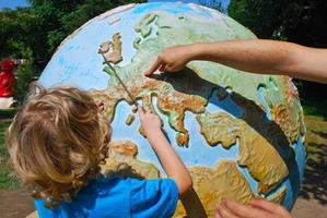
astroEDU educational activity (links to astroEDU website) Description: Use a globe to describe your position on Earth.
License: CC-BY-4.0 Creative Commons (CC) Attribution 4.0 International (CC BY 4.0) Icônes
Mots clés :
Geography
, Maps
, GPS
, Celestial navigation
Tranches d'âge :
8-10
, 10-12
, 12-14
Niveau scolaire :
Collège
, Primaire
Domaines d'apprentissage :
Apprentissage par enquête
Coûts :
Faible
Durée :
1h
Taille du groupe :
Par groupe
Compétences :
Analyser et interpréter des données
, Développer et utiliser des modèles
, Utiliser les mathématiques et la pensée computationnelle


- Ressources
- Moteur de recherche des ressources pédagogiques
- Parcourir les ressources pédagogiques par Sujet
- Parcourir les images
- AstroEdu - Activités en classe
- Grandes Idées - Littéracie en astronomie
- Glossaire
- Rapports de l'OAE
- L'astronomie pour l'Education à travers le monde
- Sélection de ressources externes