Glossary term: Sundial
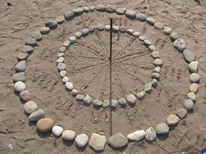
Description: The Sun's position in the sky has long been used to define time, with local noon at the point of the Sun's greatest height above the horizon and the day defined in the narrow sense as the period between sunrise and sunset, and in the broader sense as the length of time between one local noon and the next. A sundial is a device that projects the direction of the Sun onto a surface with markings, usually by tracking the shadow of an elongated pointer known as the "gnomon". When that shadow points at the marking designated "12", for instance, one would read off the time as 12 o'clock. Simple sundials only show apparent solar time, which is directly linked to the Sun's sky position. More elaborate versions have provisions for allowing the determination of mean solar time.
Related Terms:
See this term in other languages
Term and definition status: This term and its definition have been approved by a research astronomer and a teacher
The OAE Multilingual Glossary is a project of the IAU Office of Astronomy for Education (OAE) in collaboration with the IAU Office of Astronomy Outreach (OAO). The terms and definitions were chosen, written and reviewed by a collective effort from the OAE, the OAE Centers and Nodes, the OAE National Astronomy Education Coordinators (NAECs) and other volunteers. You can find a full list of credits here. All glossary terms and their definitions are released under a Creative Commons CC BY-4.0 license and should be credited to "IAU OAE".
If you notice a factual error in this glossary definition then please get in touch.
Related Activities
Making a Sundial
astroEDU educational activity (links to astroEDU website) Description: Build a sundial and discover how time can be measured.
License: CC-BY-4.0 Creative Commons Attribution 4.0 International (CC BY 4.0) icons
Tags:
Hands-on
, Measurement
, Measure
, History
, Clocks
Age Ranges:
6-8
, 8-10
, 10-12
Education Level:
Middle School
, Primary
Areas of Learning:
Modelling
, Observation based
, Social Research
Costs:
Medium Cost
Duration:
1 hour
Group Size:
Group
Skills:
Analysing and interpreting data
, Asking questions
, Communicating information
, Developing and using models
Navigate like a Viking – Use the Sun, not your phone!
astroEDU educational activity (links to astroEDU website) Description: Learn how the Vikings used the sky to navigate at sea with a hands-on activity!
License: CC-BY-4.0 Creative Commons Attribution 4.0 International (CC BY 4.0) icons
Tags:
History
, Geography
, Maps
, Coordinates
, Celestial navigation
Age Ranges:
12-14
, 14-16
Education Level:
Middle School
Areas of Learning:
Discussion Groups
, Modelling
, Social Research
Costs:
Medium Cost
Duration:
1 hour 30 mins
Group Size:
Group
Skills:
Analysing and interpreting data
, Asking questions
, Communicating information
, Developing and using models
, Planning and carrying out investigations
, Using mathematics and computational thinking


