Glossary term: Rotación de la Tierra
Description: La Tierra realiza dos movimientos simultáneos: una rotación diaria alrededor de su eje y una revolución anual (órbita) alrededor del Sol. La rotación de la Tierra alrededor de su eje da lugar a los fenómenos del día y la noche, ya que la posición de un lugar concreto con respecto al Sol cambia de forma gradual y regular a lo largo de un ciclo de 24 horas, a medida que la Tierra gira de oeste a este.
Related Terms:
See this term in other languages
Term and definition status: The original definition of this term in English have been approved by a research astronomer and a teacher The translation of this term and its definition is still awaiting approval
The OAE Multilingual Glossary is a project of the IAU Office of Astronomy for Education (OAE) in collaboration with the IAU Office of Astronomy Outreach (OAO). The terms and definitions were chosen, written and reviewed by a collective effort from the OAE, the OAE Centers and Nodes, the OAE National Astronomy Education Coordinators (NAECs) and other volunteers. You can find a full list of credits here. All glossary terms and their definitions are released under a Creative Commons CC BY-4.0 license and should be credited to "IAU OAE".
If you notice a factual or translation error in this glossary term or definition then please get in touch.
In Other Languages
- Árabe: دوران الأرض
- Alemán: Erdrotation
- Inglés: Earth's Rotation
- Francés: La rotation de la Terre
- Italiano: Rotazione della Terra
- Coreano: 지구자전
- Portugués de Brasil: Rotação da Terra
- Chino simplificado: 地球自转
- Chino tradicional: 地球自轉
Related Media
Big Dipper in Four Seasons
Caption: Winner in the 2022 IAU OAE Astrophotography Contest, category Still images of celestial patterns.
As Earth moves around the Sun, the positions of the stars in the night sky appear to change over the course of the year. This is well exemplified in this mosaic, with images taken in all four seasons throughout 2020 in the region of Veneto, Italy, showing the apparent motion of the Ursa Minor and Ursa Major constellations.
Ursa Minor, the Little Bear, is a constellation of the northern hemisphere, and it contains the northern celestial pole, in our current epoch marked by a bright star called Polaris or the Pole Star. For centuries Polaris has been used for navigation in the northern hemisphere, as it has been almost at the exact pole position for roughly 200 years. In the Middle Ages and antiquity, there was no pole star; the celestial north pole lay in a dark region and the Greeks considered the “Little She-Bear” as a companion of the “Great She-Bear”, which is more easily recognizable. The brightest stars of these constellations were alternatively also considered as chariots by the Greeks, as written in Aratus’s famous didactic poem from the 3rd century before the common era. The most famous asterism in Ursa Major, composed of seven stars, has different names across the (northern) world. While considered as a chariot by the Greeks, it is “The Northern Dipper” in China, and “The Seven Oxen” for the ancient Romans.
It was also the navigational purpose that led to the name The Great She-Bear, Ursa Major; for the Greeks, travelling towards the direction of the horizon above which Ursa Major appears meant moving towards the land of the bears (northern Europe). An animal is clearly recognizable when taking into account all the fainter stars in the vicinity of the seven bright ones. They considered it a female bear because Greek mythology connects this animal with the nymph Callisto, whose story describes the initiation rituals for women.
In the top left, we see an image taken on a spring evening, while the image below shows the same portion of the sky on a summer evening. Going counterclockwise, we see the sky during autumn in the bottom right image, while the top right finally shows this portion of the sky in the winter. Note that the relative positions of Ursa Minor and the Big Dipper don’t change, but all stars appear to be moved in a circle around Polaris. This star pointing due north lies at the point where Earth’s rotational axis intersects the celestial sphere.
The shift of constellations throughout the year is therefore a globe-clock or a globe-calendar, used by ancient civilizations to measure the year, and to predict the changes of seasons. It helps to establish, for instance, the best time for sowing and sailing as winds change with the seasons.
Credit: Giorgia Hofer/IAU OAE
License: CC-BY-4.0 Creative Commons Reconocimiento 4.0 Internacional (CC BY 4.0) icons
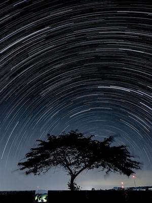
Star Trail in the Southern Hemisphere with Bortle 4 Scale Light Pollution
Caption: Winner in the 2023 IAU OAE Astrophotography Contest, category of Still images taken exclusively with smartphones/mobile devices.
This breathtaking photo, captured under the clear night sky of Linggamekar Village, Cilimus, Kuningan, West Java, Indonesia on 25 June 2020, displays star trails sweeping across the southern hemisphere’s heavens. The star trails are due to Earth’s rotation causing the apparent motion of stars, creating these mesmerising arcs of light when followed over extended periods. Here, the point the stars rotate around (the South Celestial Pole) is close to the horizon, as the image was taken close to the equator. The photographer used the star trail feature on a smartphone, which captured a series of images over an extended period and stacked them together. The striking tree in the foreground adds depth to the image, contrasting the celestial motion above with its Earthly stillness, while also masking some of the surrounding light pollution. Different parts of the world offer diverse and stunning perspectives on the night sky, emphasising the importance of preserving dark skies everywhere.
Credit: Slamat Riyadi/IAU OAE (CC BY 4.0)
License: CC-BY-4.0 Creative Commons Reconocimiento 4.0 Internacional (CC BY 4.0) icons
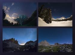
Southern Sky Over La Silla
Caption: First place winner in the 2023 IAU OAE Astrophotography Contest, category of Time-lapses of rotation of Big Dipper or Southern Cross.
This video shows the Milky Way’s sprawling brilliance across the celestial expanse. Among the stars’ grand theatre, the Southern Cross constellation claims its place in the scene, distinguished by its distinctive cross shape as seen in the top of this video and slightly to the right just over the Milky Way, slowly disappearing as the video progresses. This celestial marker, a prominent feature in the southern hemisphere, holds cultural and navigational significance, having served as a navigational guidepost for centuries. Accompanying the Milky Way’s grandeur are the two Magellanic clouds, celestial companions seen dancing in the distant sky. The Carina Nebula adds its ethereal glow to the cosmic panorama, painting a radiant hue against the darkness. In the midst of this celestial ballet, a gentle green hue envelops the atmosphere, a phenomenon known as airglow, adding a touch of subtle luminescence to the night sky. The terrestrial also makes an appearance, with planes flying overhead and vehicles driving between observatory buildings. This time-lapse, taken from the La Silla Observatory in Chile, is a window to the captivating dance of stars, offering a glimpse into the awe-inspiring beauty of our galaxy and the celestial landmarks that grace the southern sky.
Credit: José Rodrigues/IAU OAE (CC BY 4.0)
License: CC-BY-4.0 Creative Commons Reconocimiento 4.0 Internacional (CC BY 4.0) icons
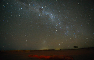
Beautiful Night in the Atacama Desert
Caption: Honorable mention in the 2023 IAU OAE Astrophotography Contest, category of Time-lapses of rotation of Big Dipper or Southern Cross.
Taken from San Pedro de Atacama, Chile, in June 2023, this time-lapse reveals the celestial ballet that unfolds as the Southern Cross takes its majestic journey across the sky, pointing the way to the South Celestial Pole around which the sky rotates, until it gracefully sets. The star-studded canvas showcases the grandeur of the Milky Way, adorned by the rotating Large and Small Magellanic Clouds swirling around the Southern Celestial Pole. The prominent constellations of Crux, Centaurus, Scorpius, and the former Argo Navis (Carina, Puppis, Vela) are also visible. The spectacle begins just after nightfall, capturing the radiant descent of Canopus, a beacon about to dip below the horizon. Throughout the sequence, there is a subtle presence of passing aeroplanes, fleeting headlights of cars, drifting clouds, and the ethereal airglow. At a stunning moment, a vivid meteor streaked across the sky, a breathtaking fireball briefly igniting the right lower corner around the 41st second mark. As the sequence progresses, the rising moon elegantly illuminates the landscape, casting its glow upon an ancient tree trunk resting on the dry, dusty grounds of the Salar de Atacama. This captivating journey through the night skies concludes before the break of dawn, offering a glimpse into the celestial marvels that are woven into the nocturnal tapestry of San Pedro de Atacama.
Credit: Uwe Reichert/IAU OAE (CC BY 4.0)
License: CC-BY-4.0 Creative Commons Reconocimiento 4.0 Internacional (CC BY 4.0) icons
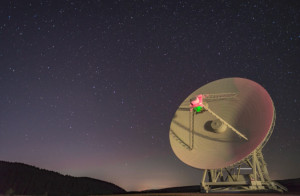
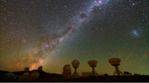
The Big Dipper with the Sardinia Radio Telescope SRT
Caption: Honorable mention in the 2023 IAU OAE Astrophotography Contest, category of Time-lapses of rotation of Big Dipper or Southern Cross.
This time-lapse captures the movement of the stars alongside the majestic 64-metre Sardinia Radio Telescope (SRT) from the National Institute of Astrophysics (INAF), with special attention to the renowned Big Dipper against the backdrop of the celestial sphere. The camera pans as the famous asterism sinks in the sky while planes fly past and the radio telescope rotates. The harmonious interplay between the stellar pathways and the colossal dish of the radio telescope creates a mesmerising visual ode to the cosmic ballet taken in September 2019.
Credit: Antonio Finazzi/IAU OAE (CC BY 4.0)
License: CC-BY-4.0 Creative Commons Reconocimiento 4.0 Internacional (CC BY 4.0) icons
Related Diagrams

Latitud y longitud
Caption: Dos vistas de la Tierra, una del hemisferio norte y otra del hemisferio sur. La Tierra rota alrededor de su eje, una línea imaginaria que la atraviesa desde el polo norte hasta el polo sur. El ecuador es una línea imaginaria que está a la misma distancia del polo norte que del polo sur.
Las posiciones de dos ciudades, Roma en el hemisferio norte y Sídney en el hemisferio sur, están marcadas aquí con puntos rojos. Las flechas indican las dos coordenadas esféricas: latitud y longitud.
La latitud marca la posición al norte o al sur del ecuador. Aquí podemos ver que Roma tiene la letra N en su latitud, puesto que se encuentra en el hemisferio norte, y Sídney tiene la letra S en su latitud, ya que se encuentra en el hemisferio sur. La latitud puede variar desde los 90° N en el polo norte, los 0° en el ecuador y hasta los 90° S en el polo sur.
La longitud mide la posición en torno al ecuador. Mientras que la elección del punto cero para la latitud en el ecuador parece obvia, la elección del punto cero para la longitud es más subjetiva. Por convenio, el punto cero en longitud es el meridiano principal que pasa por el Observatorio Real de Greenwich en el Reino Unido. Aquí se marca como una línea continua que parte del polo norte. La longitud se mide en grados al este o al oeste del meridiano de referencia. Dado que tanto Roma como Sídney se encuentran al este de Greenwich, tienen la letra E como parte de su longitud. De oeste a este, la longitud varía desde los 180° O, al otro lado del mundo respecto al meridiano de referencia, los 0° en ese meridiano, hasta alcanzar de nuevo los 180° E al otro lado del mundo respecto al meridiano de referencia.
Este diagrama muestra la Tierra en el solsticio de diciembre. Se presentan dos vistas, una del hemisferio norte y otra del hemisferio sur, unas nueve horas más tarde. La región sombreada muestra el lado nocturno de la Tierra, mientras que el lado diurno es más claro. Al ser el solsticio de diciembre, el Sol se encuentra en su punto más alto sobre el Trópico de Capricornio. Esta es una línea de latitud constante a 23°26′09,3″ S. Seis meses más tarde, en el solsticio de junio, el Sol parecerá estar en su punto más alto sobre el Trópico de Cáncer, a 23°26′09,3″ N. Cuando el Sol se eleva sobre el Trópico de Capricornio, se ilumina una mayor parte del hemisferio sur que del hemisferio norte. De hecho, por debajo del círculo antártico (el círculo polar alrededor del polo sur), el Sol no se pone en esta época del año, lo que da lugar a un día polar. Por el contrario, al norte del círculo ártico (el círculo polar alrededor del polo norte), el Sol no sale en esta época del año, lo que da lugar a una noche polar.
Credit: María Cristina Fortuna/IAU OAE
License: CC-BY-4.0 Creative Commons Reconocimiento 4.0 Internacional (CC BY 4.0) icons

