Termine del Glossario Orizzonte
Descrizione L'orizzonte è la linea di confine che separa il cielo dalla superficie terrestre. In qualsiasi posizione sulla Terra, vediamo solo una parte limitata del globo. Il confine che divide ciò che possiamo vedere da ciò che non possiamo vedere è comunemente definito orizzonte. In astronomia, questa definizione viene perfezionata come segue: La nostra posizione sulla Terra definisce un piano orizzontale, che è perpendicolare alla direzione verso il basso (che possiamo rendere visibile usando un filo a piombo). L'intersezione di questo piano con la sfera celeste definisce il nostro orizzonte astronomico locale. Il sistema di coordinate orizzontali utilizza il piano orizzontale per definire le posizioni nel cielo. L'angolo tra la nostra linea di vista su un oggetto e il piano orizzontale è chiamato altitudine dell'oggetto, mentre l'angolo tra la proiezione della linea di vista su quel piano e il nord vero è l'azimut dell'oggetto.
Termini correlati
Vedi questo termine in altre lingue
status del termine e della definizione La definizione originale di questo termine in inglese é stata approvata da un ricercatore astronomo e da un docente La traduzione di questo termine e della sua definizione sono state approvate da un ricercatore astronomo e da un docente
Il Glossario Multilingue OAE é un progetto dell'Ufficio IAU per la didatticadell'astronomia (OAE) in collaborazione con l'ufficio IAU OAO per la DivulgazioneAstronomica (OAO). I termini e le definizioni sono stater scelte, scritte eriviste da un impegno collettivo da parte di OAE, i Centri e i Nodi OAE e iCoordinatori Nazionali per la Didattica dell'Astronomia e da altri volontari.Potete trovare una lista completa dei crediti, Tutti i termini del glossarioE le definizioni sono pubblicate su Creative Commons CC BY-4.0 licenza e dovrebbero essere accreditate ad IAU OAE.
Se noti un errore di fatto o di traduzione in questo termine del glossario, per favore contattaci.
Diagrami correlati
Sistema di coordinate orizzontali
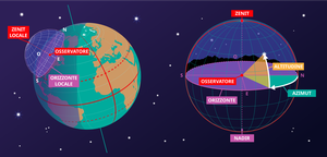
Didascalia: Questa immagine mostra il sistema di coordinate orizzontali di un osservatore sulla Terra. A destra vediamo il sistema di coordinate nel contesto locale dell'osservatore. L'osservatore appare qui come un punto circondato dalla sfera celeste. Il suolo appare come un piano; sebbene la Terra sia rotonda, possiamo approssimare il suolo nell'area circostante l'osservatore come un piano. La linea in cui questo piano interseca la sfera celeste è l'orizzonte. Il punto direttamente sopra l'osservatore è lo zenit, il punto direttamente sotto l'osservatore è il nadir, che è nascosto dal suolo.
Due coordinate definiscono questo sistema di coordinate: l'altitudine e l'azimut; ecco perché talvolta viene chiamato sistema di coordinate alt-az. L'altitudine è zero all'orizzonte, massima (90°) allo zenit e minima (-90°) al nadir. L'azimut è l'angolo rispetto all'orizzonte. Di solito è definito come zero in direzione nord. Qualsiasi punto sulla sfera celeste può essere definito da queste due coordinate. Tuttavia, quali oggetti appaiono in queste posizioni dipenderà dall'ora e dalla posizione dell'osservatore.
Nella parte sinistra del diagramma, possiamo vedere che quando collochiamo l'osservatore e il suo sistema di coordinate orizzontali locale in un contesto globale, le parti di cielo che l'osservatore può vedere dipendono dalla sua posizione sulla Terra e dalla rotazione terrestre. Lo zenit punta perpendicolarmente alla superficie terrestre, quindi la posizione nel cielo a cui corrispondono lo zenit e il nadir dipende dalla latitudine dell'osservatore. Anche l'orizzonte dipende dalla posizione dell'osservatore sulla Terra.
Crediti: Maria Cristina Fortuna/IAU OAE
License: CC-BY-4.0 Creative Commons Attribuzione 4.0 Internazionale (CC BY 4.0) icone

