Termine del Glossario Altitudine
Descrizione L'altitudine ha due significati: denota un angolo specifico in un certo tipo di sistema di coordinate ("l'altitudine di una stella") o una distanza verticale rispetto a un determinato livello di riferimento ("5000 m sul livello del mare").
In astronomia (e in topografia), l'altitudine è un angolo nei cosiddetti sistemi di coordinate orizzontali. L'angolo misura l'altezza di un oggetto sopra l'orizzonte: se si punta il dito verso l'oggetto e poi lo si abbassa verso l'orizzonte, la direzione del braccio cambierà dell'angolo che rappresenta l'altitudine. L'altitudine si misura in gradi o in radianti. Un oggetto all'orizzonte ha un'altitudine di 0°, mentre un oggetto che si trova direttamente sopra la testa, "allo zenit", ha un'altitudine di 90°. I valori negativi dell'altitudine sono assegnati agli oggetti che si trovano attualmente sotto l'orizzonte: in questo caso, l'angolo di altitudine misura quanto l'oggetto si trova sotto l'orizzonte. Un oggetto che si trova proprio sotto i vostri piedi, "al nadir", avrebbe un'altitudine di -90°.
In altri contesti, come l'aviazione o la fisica dell'atmosfera, l'altitudine è una misura dell'altezza di un luogo rispetto a un determinato livello di riferimento. Sulla Terra, l'altitudine è spesso definita come l'altezza sopra il livello medio del mare. Con questo significato, l'altitudine viene misurata in unità di lunghezza, come ad esempio i metri.
Termini correlati
Vedi questo termine in altre lingue
status del termine e della definizione La definizione originale di questo termine in inglese é stata approvata da un ricercatore astronomo e da un docente La traduzione di questo termine e della sua definizione sono state approvate da un ricercatore astronomo e da un docente
Il Glossario Multilingue OAE é un progetto dell'Ufficio IAU per la didatticadell'astronomia (OAE) in collaborazione con l'ufficio IAU OAO per la DivulgazioneAstronomica (OAO). I termini e le definizioni sono stater scelte, scritte eriviste da un impegno collettivo da parte di OAE, i Centri e i Nodi OAE e iCoordinatori Nazionali per la Didattica dell'Astronomia e da altri volontari.Potete trovare una lista completa dei crediti, Tutti i termini del glossarioE le definizioni sono pubblicate su Creative Commons CC BY-4.0 licenza e dovrebbero essere accreditate ad IAU OAE.
Se noti un errore di fatto o di traduzione in questo termine del glossario, per favore contattaci.
Diagrami correlati
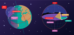
Sistema di coordinate orizzontali
Didascalia: Questa immagine mostra il sistema di coordinate orizzontali di un osservatore sulla Terra. A destra vediamo il sistema di coordinate nel contesto locale dell'osservatore. L'osservatore appare qui come un punto circondato dalla sfera celeste. Il suolo appare come un piano; sebbene la Terra sia rotonda, possiamo approssimare il suolo nell'area circostante l'osservatore come un piano. La linea in cui questo piano interseca la sfera celeste è l'orizzonte. Il punto direttamente sopra l'osservatore è lo zenit, il punto direttamente sotto l'osservatore è il nadir, che è nascosto dal suolo.
Due coordinate definiscono questo sistema di coordinate: l'altitudine e l'azimut; ecco perché talvolta viene chiamato sistema di coordinate alt-az. L'altitudine è zero all'orizzonte, massima (90°) allo zenit e minima (-90°) al nadir. L'azimut è l'angolo rispetto all'orizzonte. Di solito è definito come zero in direzione nord. Qualsiasi punto sulla sfera celeste può essere definito da queste due coordinate. Tuttavia, quali oggetti appaiono in queste posizioni dipenderà dall'ora e dalla posizione dell'osservatore.
Nella parte sinistra del diagramma, possiamo vedere che quando collochiamo l'osservatore e il suo sistema di coordinate orizzontali locale in un contesto globale, le parti di cielo che l'osservatore può vedere dipendono dalla sua posizione sulla Terra e dalla rotazione terrestre. Lo zenit punta perpendicolarmente alla superficie terrestre, quindi la posizione nel cielo a cui corrispondono lo zenit e il nadir dipende dalla latitudine dell'osservatore. Anche l'orizzonte dipende dalla posizione dell'osservatore sulla Terra.
Crediti: Maria Cristina Fortuna/IAU OAE
License: CC-BY-4.0 Creative Commons Attribuzione 4.0 Internazionale (CC BY 4.0) icone

