Glossary term: 해시계
Description: 하늘에서 태양의 위치는 오랫동안 시간을 재는 기준으로 사용되어 왔습니다. 태양이 지평선 위에서 가장 높이 떠 있는 순간을 현지 정오라고 하며,
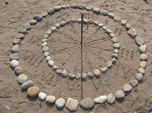
‘하루’는 좁은 의미로는 일출부터 일몰까지의 시간, 넓은 의미로는 한 정오에서 다음 정오까지의 시간으로 정의됩니다. 해시계 는 태양의 위치를 이용해 시간을 알려주는 장치입니다. 해시계에는 ‘노우몬(gnomon)’이라고 불리는 막대나 포인터가 있고, 이것이 만든 그림자의 방향과 길이를 통해 시간을 읽을 수 있습니다. 예를 들어 그림자가 ‘12’ 표시를 가리키면, 그때의 시간은 12시입니다. 단순한 해시계는 태양의 실제 위치에 따라 변하는 겉보기 태양 시간만 보여줍니다. 하지만 좀 더 정교한 해시계는 평균 태양 시간을 표시할 수 있도록 설계되어 있습니다.
Related Terms:
See this term in other languages
Term and definition status: The original definition of this term in English have been approved by a research astronomer and a teacher The translation of this term and its definition is still awaiting approval
The OAE Multilingual Glossary is a project of the IAU Office of Astronomy for Education (OAE) in collaboration with the IAU Office of Astronomy Outreach (OAO). The terms and definitions were chosen, written and reviewed by a collective effort from the OAE, the OAE Centers and Nodes, the OAE National Astronomy Education Coordinators (NAECs) and other volunteers. You can find a full list of credits here. All glossary terms and their definitions are released under a Creative Commons CC BY-4.0 license and should be credited to "IAU OAE".
If you notice a factual or translation error in this glossary term or definition then please get in touch.
In Other Languages
- 아랍어: الساعة الشمسية
- 독일어: Sonnenuhr
- 영어: Sundial
- 스페인어: Reloj de sol
- 프랑스어: Cadran solaire
- 이탈리아어: Meridiana
- 브라질 포르투갈어: Relógio de sol
- 알바니아어: Orë diellore
- 중국어 간체: 日晷
- 중국어 번체: 日晷
Related Activities
Making a Sundial
astroEDU educational activity (links to astroEDU website) Description: Build a sundial and discover how time can be measured.
License: CC-BY-4.0 Creative Commons 저작자표시 4.0 국제 (CC BY 4.0) icons
Tags:
Hands-on
, Measurement
, Measure
, History
, Clocks
Age Ranges:
6-8
, 8-10
, 10-12
Education Level:
Middle School
, Primary
Areas of Learning:
Modelling
, Observation based
, Structured-inquiry learning
Costs:
Medium Cost
Duration:
1 hour
Group Size:
Group
Skills:
Analysing and interpreting data
, Asking questions
, Communicating information
, Developing and using models

Navigate like a Viking – Use the Sun, not your phone!
astroEDU educational activity (links to astroEDU website) Description: Learn how the Vikings used the sky to navigate at sea with a hands-on activity!
License: CC-BY-4.0 Creative Commons 저작자표시 4.0 국제 (CC BY 4.0) icons
Tags:
History
, Geography
, Maps
, Coordinates
, Celestial navigation
Age Ranges:
12-14
, 14-16
Education Level:
Middle School
Areas of Learning:
Discussion Groups
, Modelling
, Structured-inquiry learning
Costs:
Medium Cost
Duration:
1 hour 30 mins
Group Size:
Group
Skills:
Analysing and interpreting data
, Asking questions
, Communicating information
, Developing and using models
, Planning and carrying out investigations
, Using mathematics and computational thinking

