Glossary term: Solstice
Description: Earth's axis is not perpendicular to Earth's orbit around the Sun, but inclined at an angle of 23.4 degrees from the perpendicular. In consequence, at different parts of its orbit, the angle between Earth's axis and our sightline to the Sun varies over one year. The practical effect is that for an observer on Earth, the highest point that the Sun will reach above the horizon in a given day will vary. The northern summer solstice, which is also the southern winter solstice, occurs around June 21 and is the time when the Sun is highest above the horizon in the northern hemisphere and at the same time lowest in the southern hemisphere. The southern summer solstice, which is also the northern winter solstice, occurs around December 21 and is the time the Sun is highest in the southern and at the same time lowest in the northern hemisphere.
Related Terms:
See this term in other languages
Term and definition status: This term and its definition have been approved by a research astronomer and a teacher
The OAE Multilingual Glossary is a project of the IAU Office of Astronomy for Education (OAE) in collaboration with the IAU Office of Astronomy Outreach (OAO). The terms and definitions were chosen, written and reviewed by a collective effort from the OAE, the OAE Centers and Nodes, the OAE National Astronomy Education Coordinators (NAECs) and other volunteers. You can find a full list of credits here. All glossary terms and their definitions are released under a Creative Commons CC BY-4.0 license and should be credited to "IAU OAE".
If you notice a factual error in this glossary definition then please get in touch.
In Other Languages
- Arabic: الانقلاب الشمسي
- German: Sonnenwende
- Spanish: Solsticio
- French: Solstice
- Italian: Solstizio
- Brazilian Portuguese: Solstício
- Simplified Chinese: 二至点
- Traditional Chinese: 二至點
Related Media
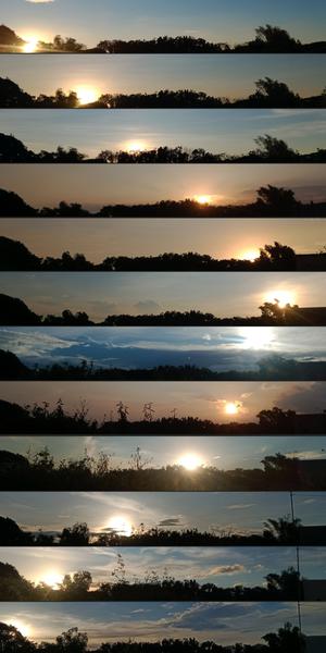
Where the Sun Sets Every Month
Caption: Third place winner in the 2023 IAU OAE Astrophotography Contest, category of Still images of sunrise and sunset location over the year.
Taken with a smartphone from San Rafael, Bulacan, Philippines, this series of images capture the changing position of sunset over the year owing to Earth’s axial tilt and orbit around the Sun. From January to December 2022, each image reflects the changing backdrop and position of the Sun at dusk. Observe the changing foliage and the appearance of an electricity pole in October. This collection serves as a visual testament to the celestial dance between Earth and the Sun, and the natural transformations on the ground.
Credit: John Paul Pile/IAU OAE (CC BY 4.0)
License: CC-BY-4.0 Creative Commons Attribution 4.0 International (CC BY 4.0) icons
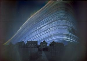
The Path of the Sun
Caption: Second place winner in the 2023 IAU OAE Astrophotography Contest, category of Still images of day arcs of the Sun and Solargraphs.
This enchanting image, captured in Germany between 21 June 2018 and 21 December 2018, is a poetic blend of art and science, showcasing nature's rhythm and the passage of time. It combines images taken at different times of day over the course of six months. Each curve tracks the Sun’s path (or arc) across the sky on a particular day. The sweeping arc of the Sun is distorted here by the projection, making it appear like a curve. The position of the daily arc across the sky changes with the Sun’s seasonal movement in the sky. Captured using a simple pinhole camera fashioned from a coffee can, it shows the Sun's journey over the course of six months, and the gradual shift of the daily arc from the summer, when it is higher in the sky, to its lowest arc at the winter solstice. Gaps in the Sun’s path represent days or times of day when the Sun was obscured by clouds. This image is a vivid testament to the changing seasons, revealing the Sun's dance in the sky as days grow shorter or longer.
Credit: Frank Niessen/IAU OAE (CC BY 4.0)
License: CC-BY-4.0 Creative Commons Attribution 4.0 International (CC BY 4.0) icons
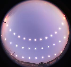
Solstices and Equinox
Caption: Honorable mention in the 2023 IAU OAE Astrophotography Contest, category of Still images of day arcs of the Sun and Solargraphs.
This captivating image showcases the journey of the Sun through the sky during the winter solstice (bottom), equinox (middle), and summer solstice (top) in Bursa, Turkey, between 21 December 2007 and 20 June 2008. Using a fisheye lens, the photographer captured the Sun's positions at regular intervals from sunrise to sunset on the three different days, illustrating the changing lengths of day and night throughout the year. The variations in the Sun’s daily path across the sky, its height at midday, and the positions of sunrise and sunset, as well as the length of a day, depend on Earth’s axial tilt relative to its orbit around the Sun. The series was taken from a rooftop in Bursa, where the local terrain adds its own unique touch by occasionally obstructing the horizon. Oriented with north at the top and south at the bottom, this visual diary serves as a stunning representation of the Sun’s path for those residing in mid-northern latitudes.
Credit: Tunç Tezel/IAU OAE (CC BY 4.0)
License: CC-BY-4.0 Creative Commons Attribution 4.0 International (CC BY 4.0) icons
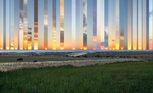
Occasive Amplitude
Caption: Second place winner in the 2023 IAU OAE Astrophotography Contest, category of Still images of sunrise and sunset location over the year.
Captured from Gatto Corvino village in Sicily, this composite showcases the Sun setting at various points over the sea from the winter to the summer solstice (2016–2017). The centre frame marks due west. As Earth orbits the Sun, the position of the setting (and rising) Sun changes from being northward of due west (east) in summer to southward of due west (east) in winter. During the equinoxes — when day and night are of equal length — the Sun rises directly in the east and sets directly in the west. The changing location of the Sun on the horizon is due to Earth’s axial tilt as it orbits the Sun. In temperate regions of Earth, the Sun’s height above the horizon at noon is at its highest and lowest points in the sky on the summer and winter solstices respectively.
Credit: Marcella Giulia Pace/IAU OAE (CC BY 4.0)
License: CC-BY-4.0 Creative Commons Attribution 4.0 International (CC BY 4.0) icons
Related Diagrams

Solstices and Equinoxes
Caption: This diagram demonstrates the relative positions of the Earth and Sun at the two solstices and two equinoxes. The Earth’s rotation axis is tilted by 23.4° from the axis of its orbit. This means that for half the Earth’s annual orbit around the Sun, the Southern Hemisphere is tilted towards the Sun and the Northern Hemisphere is tilted away from the Sun. During this time the Sun appears to lie below the celestial equator. Due to this at any particular point in the Southern Hemisphere the Sun will appear to be higher above the horizon at a particular time of day and the days will be longer. Conversely during this time, the Sun appears lower in the sky at any particular point in the day in the Northern Hemisphere and the days are shorter.
This effect is most pronounced in late December when the Sun appears at its most southerly point in the sky, corresponding to the longest day of the year in the Southern Hemisphere. This normally occurs on the 21st or 22nd of December (UTC), depending on when the most recent leap year was, but can very occasionally occur on the 20th or 23rd of December. This event is known as the December solstice. As the Sun’s rays hit the Southern Hemisphere at a more perpendicular angle during this time, the Southern Hemisphere is typically warmer in this time of year than at other times of year. This is often referred to as summer in temperate and antarctic regions of the Southern Hemisphere and thus the December solstice is known as the summer solstice. South of the Antarctic Circle at this time the Sun never sets and a Polar Day can last several months. Conversely in the Northern Hemisphere, the Sun’s rays hit the Earth at a more grazing angle than at other times of year so it is colder and this solstice is known as the winter solstice. North of the Arctic Circle the Sun never rises during this time and the Polar Night can last several months.
As the year progresses the Earth moves in its orbit and the tilt of the Earth’s axis moves so it appears more side-on to the Sun. From the perspective of an observer on Earth this means that the Sun moves north in the sky, eventually reaching the celestial equator in late March, This usually occurs on the 20th of March (UTC) but can sometimes occur on the 19th or 21st of March. During this time all places on Earth will experience night and day that is approximately 12 hours long. The Sun’s rays now hit the Southern hemisphere at a more shallow angle than they did in December and hit the Northern Hemisphere at a more perpendicular angle. This means that the Northen Hemisphere will have warmed since December and the Southern Hemisphere cooled. This leads to the March equinox being referred to as the autumn equinox in the Southern Hemisphere and the spring or vernal equinox in the Northern Hemisphere.
As the year progresses further the Sun moves further north on the sky, the Northern Hemisphere days lengthen and the Southern Hemisphere days shorten. By June the Earth’s orbit has progressed to the point where the Northern Hemisphere points towards the Sun and the Southern Hemisphere away from the Sun. At one point between the 20th and 22nd of June (UTC) the Sun reaches its most northerly point in the sky, this is known as June solstice. It is now summer in northern temperate and artic regions so this is known as the summer solstice in the Northern Hemisphere and the winter solstice in the Southern Hemisphere. This is the longest day of the year in the Northern Hemisphere and the shortest day of the year in the Southern Hemisphere. During this time regions north of the Arctic Circle experience a long Polar Day and regions south of the Antarctic Circle experience polar night.
The year progresses further and the Earth moves in its orbit so that the tilt of the Earth’s axis again appears side-on for the Sun. The Sun moves south in the sky and again crosses the celestial equator between the 21st and 24th of September (UTC). At this time all places on the Earth experience equal lengths of day and night. This is known as the September equinox, also called the spring or vernal equinox in the Southern Hemisphere and the autumn equinox in the Northern Hemisphere.
Note the sizes of the Earth, Sun and the Earth’s orbit around the Sun are not to scale in this diagram.
Credit: Maria Cristina Fortuna/IAU OAE
License: CC-BY-4.0 Creative Commons Attribution 4.0 International (CC BY 4.0) icons

Seasons
Caption: This diagram shows the Earth at the June solstice which is known as the summer solstice in the Northern Hemisphere and the winter solstice in the Southern Hemisphere. The Earth’s axis of rotation is tilted from the axis of the Earth’s orbit around the Sun by 23.4°. Here we see light from the sun represented as parallel lines, in the diagram the Sun would lie far off the right-hand edge. Five lines are marked with angles. These lines hit the Earth at special latitudes. From top to bottom these lines hit the Earth at the North Pole, the Tropic of Cancer, the Equator, the Tropic of Capricorn and the Antarctic Circle. The lines are shown hitting the Earth at the longitude where it is currently noon. For the last four lines, the angles marked show the angle above the horizon (the altitude) which the Sun appears in the sky at at local noon.
At the June solstice, the Sun will appear directly overhead at local noon on every point on the Tropic of Capricorn. By contrast the Sun reaches a maximum altitude of 0° at local noon on every point in the Antarctic Circle. This means the Sun never rises and every point south of the Antarctic Circle experiences a long Polar Night. By contrast the Sun never sets on this day north of the Arctic Circle and the regions here experience a Polar Day. The at the North Pole the Sun will remain at a constant altitude all day. This altitude will be the angle 180°-156.6° (23.4°).
The altitude the Sun appears at is important as it defines how spread out the Sun’s rays are on the Earth’s surface. Look at the thick, faint parallel lines in the background. Notice how at the Tropic of Cancer the area the lines intersect with the Earth’s surface perpendicularly and the line only covers a small part of the Earth’s surface. Now look at a line near the Tropic of Capricorn and see that this intersects with the Earth at a grazing angle and the line is spread out, covering a much wider area of the Earth’s surface. This means that a given amount of light from the Sun that hits the Tropic of Cancer is more concentrated and the same amount of light hitting the Tropic of Capricorn would be more spread out. This leads to more energy per unit area from the Sun hitting the Tropic of Cancer and less energy per unit area hitting the Tropic of Capricorn. This means it will be warmer at the Tropic of Cancer than at the Tropic of Capricorn. It is thus summer at the Tropic of Cancer and winter at the Tropic of Capricorn.
Six months later this situation will be reversed and it will be summer at the Tropic of Capricorn and winter at the Tropic of Cancer.
Credit: Maria Cristina Fortuna/IAU OAE
License: CC-BY-4.0 Creative Commons Attribution 4.0 International (CC BY 4.0) icons

