Glossary term: Círculo Polar Ártico
Description: Los círculos polares son líneas de latitud de la Tierra. El círculo polar situado a 66°33′48.8″ N se denomina Círculo Polar Ártico y el círculo polar situado a 66°33′48.8″ S se denomina Círculo Polar Antártico. Debido a la inclinación del eje de rotación de la Tierra, las regiones al norte del Círculo Polar Ártico y al sur del Círculo Polar Antártico experimentan «noches polares» durante su invierno y «días polares» durante su verano. Durante una noche polar, el Sol permanece por debajo del horizonte durante más de 24 horas y este periodo de oscuridad puede durar meses. Durante un día polar, el Sol permanece por encima del horizonte durante más de 24 horas y el día puede durar meses. Los días y las noches polares son más largos cuanto más cerca se está de los polos. Las noches polares tienen lugar antes y después del solsticio de invierno de cada región polar, mientras que los días polares se producen antes y después del solsticio de verano.
Related Terms:
See this term in other languages
Term and definition status: The original definition of this term in English have been approved by a research astronomer and a teacher The translation of this term and its definition is still awaiting approval
The OAE Multilingual Glossary is a project of the IAU Office of Astronomy for Education (OAE) in collaboration with the IAU Office of Astronomy Outreach (OAO). The terms and definitions were chosen, written and reviewed by a collective effort from the OAE, the OAE Centers and Nodes, the OAE National Astronomy Education Coordinators (NAECs) and other volunteers. You can find a full list of credits here. All glossary terms and their definitions are released under a Creative Commons CC BY-4.0 license and should be credited to "IAU OAE".
If you notice a factual or translation error in this glossary term or definition then please get in touch.
In Other Languages
- Árabe: الدائرة القطبية
- Alemán: Polarkreis
- Inglés: Polar Circle
- Francés: Cercle polaire
- Italiano: Circolo polare
- Coreano: 극권
- Maratí: ध्रुवीय वर्तुळ
- Nepalí: ध्रुवीय वृत्त
- Portugués de Brasil: Círculo Polar
- Chino simplificado: 极圈
- Chino tradicional: 極圈
Related Media
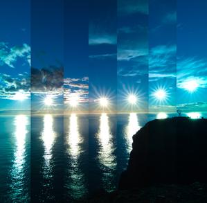
When the Sun Bounces
Caption: First place winner in the 2023 IAU OAE Astrophotography Contest, category of Still images of sunrise and sunset location over the year.
This image was taken at Norway's North Cape. Owing to the latitude of this location, the Sun never truly sets during the summer months, from around April to August. This results in the unique spectacle of continuous daylight, known as a polar day. This captivating series of images, taken in 2022, showcases the Sun's relentless journey across the horizon every 30 minutes. At its lowest point in the sky, the Sun does not set, but appears to bounce off the horizon. The globe on the far right in the photo stands as a sentinel, marking the northernmost point of the European continental mainland.
Credit: Milos Obert/IAU OAE (CC BY 4.0)
License: CC-BY-4.0 Creative Commons Reconocimiento 4.0 Internacional (CC BY 4.0) icons
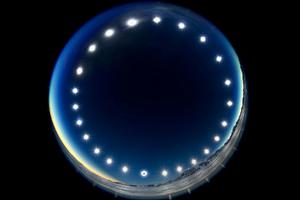
The Eclipse Clock-Eclipse on a Polar Day
Caption: First place winner in the 2023 IAU OAE Astrophotography Contest, category of Still images of day arcs of the Sun and Solargraphs.
Constructed by combining multiple images over the course of a 24-hour period, the image was captured in Union Glacier, Antarctica, during the total solar eclipse of 4 December 2021, and showcases the day arc of the Sun. It illustrates the unique phenomenon of a polar day, during which the Sun travels around the sky without setting. During polar days, areas within the polar circles experience 24 hours of continuous daylight, and the Sun doesn’t set for an extended period. The image also offers a rare perspective of a solar eclipse, where the Moon passes between the Sun and Earth, and as viewed from Earth. This can be seen in the lower image of the Sun, where the Moon covers the solar disc.
Credit: Stephanie Ziyi Ye/IAU OAE (CC BY 4.0)
License: CC-BY-4.0 Creative Commons Reconocimiento 4.0 Internacional (CC BY 4.0) icons
Related Diagrams

Latitud y longitud
Caption: Dos vistas de la Tierra, una del hemisferio norte y otra del hemisferio sur. La Tierra rota alrededor de su eje, una línea imaginaria que la atraviesa desde el polo norte hasta el polo sur. El ecuador es una línea imaginaria que está a la misma distancia del polo norte que del polo sur.
Las posiciones de dos ciudades, Roma en el hemisferio norte y Sídney en el hemisferio sur, están marcadas aquí con puntos rojos. Las flechas indican las dos coordenadas esféricas: latitud y longitud.
La latitud marca la posición al norte o al sur del ecuador. Aquí podemos ver que Roma tiene la letra N en su latitud, puesto que se encuentra en el hemisferio norte, y Sídney tiene la letra S en su latitud, ya que se encuentra en el hemisferio sur. La latitud puede variar desde los 90° N en el polo norte, los 0° en el ecuador y hasta los 90° S en el polo sur.
La longitud mide la posición en torno al ecuador. Mientras que la elección del punto cero para la latitud en el ecuador parece obvia, la elección del punto cero para la longitud es más subjetiva. Por convenio, el punto cero en longitud es el meridiano principal que pasa por el Observatorio Real de Greenwich en el Reino Unido. Aquí se marca como una línea continua que parte del polo norte. La longitud se mide en grados al este o al oeste del meridiano de referencia. Dado que tanto Roma como Sídney se encuentran al este de Greenwich, tienen la letra E como parte de su longitud. De oeste a este, la longitud varía desde los 180° O, al otro lado del mundo respecto al meridiano de referencia, los 0° en ese meridiano, hasta alcanzar de nuevo los 180° E al otro lado del mundo respecto al meridiano de referencia.
Este diagrama muestra la Tierra en el solsticio de diciembre. Se presentan dos vistas, una del hemisferio norte y otra del hemisferio sur, unas nueve horas más tarde. La región sombreada muestra el lado nocturno de la Tierra, mientras que el lado diurno es más claro. Al ser el solsticio de diciembre, el Sol se encuentra en su punto más alto sobre el Trópico de Capricornio. Esta es una línea de latitud constante a 23°26′09,3″ S. Seis meses más tarde, en el solsticio de junio, el Sol parecerá estar en su punto más alto sobre el Trópico de Cáncer, a 23°26′09,3″ N. Cuando el Sol se eleva sobre el Trópico de Capricornio, se ilumina una mayor parte del hemisferio sur que del hemisferio norte. De hecho, por debajo del círculo antártico (el círculo polar alrededor del polo sur), el Sol no se pone en esta época del año, lo que da lugar a un día polar. Por el contrario, al norte del círculo ártico (el círculo polar alrededor del polo norte), el Sol no sale en esta época del año, lo que da lugar a una noche polar.
Credit: María Cristina Fortuna/IAU OAE
License: CC-BY-4.0 Creative Commons Reconocimiento 4.0 Internacional (CC BY 4.0) icons
Related Activities
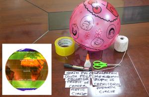
Discover Earth's climate with a balloon
astroEDU educational activity (links to astroEDU website) Description: Discover the secrets of Earth's climate zones with a hands-on experience
License: CC-BY-4.0 Creative Commons Reconocimiento 4.0 Internacional (CC BY 4.0) icons
Age Ranges:
8-10
, 10-12
Education Level:
Middle School
, Primary
Areas of Learning:
Fun activity
, Guided-discovery learning
, Modelling
, Observation based
, Project-based learning
, Structured-inquiry learning
Costs:
Low Cost
Duration:
45 mins
Group Size:
Group
Skills:
Asking questions
, Constructing explanations
, Developing and using models

