Termine del Glossario Circolo polare
Descrizione I circoli polari sono linee di latitudine sulla Terra. Il circolo polare a 66°33′48,8″ N è chiamato Circolo polare artico e il circolo polare a 66°33′48,8″ S è chiamato Circolo polare antartico. A causa dell'inclinazione dell'asse di rotazione terrestre, le regioni a nord del Circolo polare artico e a sud del Circolo polare antartico sperimentano "notti polari" durante l'inverno e "giorni polari" durante l'estate. Nel corso di una notte polare il Sole è sotto l'orizzonte per più di 24 ore e questo periodo di oscurità può durare mesi. Lungo un giorno polare il Sole è sopra l'orizzonte per più di 24 ore e il giorno può durare per mesi. I giorni e le notti polari sono più lunghi vicino ai poli. Le notti polari si verificano prima e dopo il solstizio d'inverno di ogni regione polare, mentre i giorni polari hanno luogo prima e dopo il solstizio d'estate.
Termini correlati
Vedi questo termine in altre lingue
status del termine e della definizione La definizione originale di questo termine in inglese é stata approvata da un ricercatore astronomo e da un docente La traduzione di questo termine e della sua definizione sono ancora in attesa di approvazione
Il Glossario Multilingue OAE é un progetto dell'Ufficio IAU per la didatticadell'astronomia (OAE) in collaborazione con l'ufficio IAU OAO per la DivulgazioneAstronomica (OAO). I termini e le definizioni sono stater scelte, scritte eriviste da un impegno collettivo da parte di OAE, i Centri e i Nodi OAE e iCoordinatori Nazionali per la Didattica dell'Astronomia e da altri volontari.Potete trovare una lista completa dei crediti, Tutti i termini del glossarioE le definizioni sono pubblicate su Creative Commons CC BY-4.0 licenza e dovrebbero essere accreditate ad IAU OAE.
Se noti un errore di fatto o di traduzione in questo termine del glossario, per favore contattaci.
In Altre Lingue
- Arabo: الدائرة القطبية
- Tedesco: Polarkreis
- Inglese: Polar Circle
- Spagnolo: Círculo Polar Ártico
- Francese: Cercle polaire
- Coreano: 극권
- Marathi: ध्रुवीय वर्तुळ
- Nepali: ध्रुवीय वृत्त
- Brasiliano Portoghese: Círculo Polar
- Cinese semplificato: 极圈
- Cinese tradizionale: 極圈
File multimediali correlati
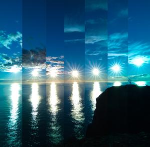
Quando il sole rimbalza
Didascalia: Vincitore del primo posto del concorso di astrofotografia IAU OAE 2023, categoria Immagini di luoghi di alba e tramonto nel corso dell'anno: Quando il Sole Rimbalza, di Milos Obert.
Il primo posto nella categoria Immagini fisse dell'alba e del tramonto nel corso dell'anno spetta a questa immagine scattata a Capo Nord in Norvegia. A causa della latitudine di questa località, il sole non tramonta mai veramente durante i mesi estivi, da aprile ad agosto circa. Ne consegue lo spettacolo unico della luce diurna continua, noto come giorno polare. Questa affascinante serie di immagini, scattate nel 2022, mostra l'incessante viaggio del Sole attraverso l'orizzonte ogni 30 minuti. Nel punto più basso del cielo, il Sole non tramonta, ma sembra rimbalzare sull'orizzonte. Il globo all'estrema destra della foto marca il punto più settentrionale della terraferma europea.
Crediti: Milos Obert/IAU OAE (CC BY 4.0)
License: CC-BY-4.0 Creative Commons Attribuzione 4.0 Internazionale (CC BY 4.0) icone
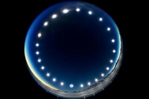
L'orologio dell'eclissi - L'eclissi in una giornata polare
Didascalia: Vincitore del primo posto al concorso di astrofotografia IAU OAE 2023, categoria Immagini fisse dell'arco diurno del Sole e solargrafie:L'orologio dell'eclissi - L'eclissi in una giornata polare , di Stephanie Ziyi Ye
Questa splendida immagine composita si è aggiudicata il primo posto nella categoria Immagini fisse dell'arco diurno del Sole e solargrafie. Costruita combinando più immagini nel corso di un periodo di 24 ore, l'immagine è stata catturata a Union Glacier, in Antartide, durante l'eclissi solare totale del 4 dicembre 2021 e mostra l'arco diurno del Sole. Illustra il fenomeno unico di un giorno polare, durante il quale il Sole compie un giro del cielo senza tramontare. Durante i giorni polari, le aree all'interno dei circoli polari sperimentano 24 ore di luce continua e il Sole non tramonta per un periodo prolungato. L'immagine offre anche una rara prospettiva di un'eclissi solare, in cui la Luna passa tra il Sole e la Terra, vista dalla Terra. Ciò è visibile nell'immagine inferiore del Sole, dove la Luna copre il disco solare.
Crediti: Stephanie Ziyi Ye/IAU OAE (CC BY 4.0)
License: CC-BY-4.0 Creative Commons Attribuzione 4.0 Internazionale (CC BY 4.0) icone
Diagrami correlati

Latitude and Longitude
Didascalia: Two views of the Earth, one viewing the Northern Hemisphere, one viewing the Southern Hemisphere. The Earth rotates around its axis, an imaginary line that runs through the Earth from the North Pole to the South Pole. The Equator is an imaginary line that is the same distant from both the North Pole and the South Pole.
The positions of two cities, Rome in the Northern Hemisphere and Sydney in the Southern Hemisphere are marked here with red dots. Arrows indicate the two spherical coordinates latitude and longitude.
Latitude marks the position north or south of the equator. Here we can see Rome has the letter N in its latitude as it is in the Northern Hemisphere and Sydney has the letter S in its latitude as it is in the Southern Hemisphere. Latitude can vary from 90° N at the North Pole to 0° at the Equator to 90° S at the South Pole.
Longitude measures the position around the equator. While the choice of the zero point for latitude as the equator seems obvious, the choice of the zero point for longitude is more subjective. By convention the zero point in longitude is the prime meridian which passes through the Royal Greenwich Observatory in the UK. This is marked here as a solid line originating at the North Pole. Longitude is measured in degrees east or west of the prime meridian. As both Rome and Sydney lie to the east of Greenwich, they have the letter E as part of their longitude. Moving west to east, longitude varies from 180° W on the other side of the world from the prime meridian to 0° on the prime meridian before reaching 180° E again on the other side of world from the prime meridian.
This diagram shows the Earth at the December solstice. Two views are presented, one viewing the Northern Hemisphere and one viewing the Southern Hemisphere about nine hours later. The shaded region shows the night side of the Earth, with the day side being lighter. As it is the December solstice, the Sun appears overhead at the Tropic of Capricorn. This is a line of constant latitude at 23°26′09.3″ S. Six months later, at the June solstice, the Sun will appear to be overhead at the Tropic of Cancer at 23°26′09.3″ N. As the Sun appears over the Tropic of Capricorn more of the Southern Hemisphere is illuminated than the Northern Hemisphere. Indeed below the Antarctic Circle (the Polar Circle around the South Pole) the Sun does not set at this time of year leading to a Polar Day. Conversely, north of the Arctic Circle (the Polar Circle around the North Pole) the Sun does not rise at this time of year, leading to a Polar Night.
Crediti: Maria Cristina Fortuna/IAU OAE
License: CC-BY-4.0 Creative Commons Attribuzione 4.0 Internazionale (CC BY 4.0) icone
Attività correlate

Discover Earth's climate with a balloon
astroEDU educational activity (links to astroEDU website) Description: Discover the secrets of Earth's climate zones with a hands-on experience
License: CC-BY-4.0 Creative Commons Attribuzione 4.0 Internazionale (CC BY 4.0) icone
Fasce d'età
8-10
, 10-12
Livello di istruzione
Middle School
, Primary
Aree di apprendimento
Fun activity
, Guided-discovery learning
, Modelling
, Observation based
, Project-based learning
, Social Research
Costi:
Low Cost
Durata:
45 mins
Dimensione del Gruppo:
Group
Abilità:
Asking questions
, Constructing explanations
, Developing and using models

