Termine del Glossario Asse terrestre
Descrizione L'asse terrestre è una linea retta immaginaria attorno alla quale la Terra ruota una volta al giorno. I due punti in cui l'asse e la superficie terrestre si intersecano definiscono il Polo Nord geografico a una latitudine di 90°N e il Polo Sud geografico a una latitudine di 90°S. L'equatore, invece, è una linea immaginaria in cui un piano perpendicolare all'asse terrestre si interseca con la superficie terrestre alla massima distanza dall'asse. L'equatore ha una latitudine di 0°.
I poli geografici non corrispondono ai poli magnetici Nord e Sud della Terra: i poli magnetici sono definiti come i punti della superficie in cui il campo magnetico terrestre punta rispettivamente verso il basso e verso l'alto.
Anche l'orbita terrestre ha un asse: la direzione perpendicolare al piano orbitale della Terra. L'asse terrestre è inclinato di 23,4° rispetto all'asse orbitale. Questa inclinazione è la causa delle stagioni terrestri. In particolare, nel corso di un'orbita, ci sono fasi in cui l'emisfero settentrionale o quello meridionale sono inclinati verso il Sole, ricevendo così più luce.
Rispetto agli oggetti celesti più lontani, la direzione verso cui punta l'asse terrestre cambia lentamente nel tempo, in quella che viene chiamata precessione assiale della Terra. Attualmente, l'asse terrestre interseca la sfera celeste in prossimità di Polaris, la stella polare. Ma nel corso di circa 26.000 anni, questo punto di intersezione descrive un piccolo cerchio nel cielo. I sistemi di coordinate celesti che definiscono le coordinate del cielo in riferimento alla Terra devono tenere conto dei minuscoli spostamenti di coordinate risultanti nel tempo.
Termini correlati
Vedi questo termine in altre lingue
status del termine e della definizione La definizione originale di questo termine in inglese é stata approvata da un ricercatore astronomo e da un docente La traduzione di questo termine e della sua definizione sono state approvate da un ricercatore astronomo e da un docente
Il Glossario Multilingue OAE é un progetto dell'Ufficio IAU per la didatticadell'astronomia (OAE) in collaborazione con l'ufficio IAU OAO per la DivulgazioneAstronomica (OAO). I termini e le definizioni sono stater scelte, scritte eriviste da un impegno collettivo da parte di OAE, i Centri e i Nodi OAE e iCoordinatori Nazionali per la Didattica dell'Astronomia e da altri volontari.Potete trovare una lista completa dei crediti, Tutti i termini del glossarioE le definizioni sono pubblicate su Creative Commons CC BY-4.0 licenza e dovrebbero essere accreditate ad IAU OAE.
Se noti un errore di fatto o di traduzione in questo termine del glossario, per favore contattaci.
In Altre Lingue
- Arabo: محور الأرض
- Tedesco: Erdachse
- Inglese: Earth's Axis
- Spagnolo: El eje de rotación de la Tierra
- Francese: Axe de la Terre
- Brasiliano Portoghese: Eixo da Terra
- Cinese semplificato: 地轴
- Cinese tradizionale: 地軸
Diagrami correlati

Latitude and Longitude
Didascalia: Two views of the Earth, one viewing the Northern Hemisphere, one viewing the Southern Hemisphere. The Earth rotates around its axis, an imaginary line that runs through the Earth from the North Pole to the South Pole. The Equator is an imaginary line that is the same distant from both the North Pole and the South Pole.
The positions of two cities, Rome in the Northern Hemisphere and Sydney in the Southern Hemisphere are marked here with red dots. Arrows indicate the two spherical coordinates latitude and longitude.
Latitude marks the position north or south of the equator. Here we can see Rome has the letter N in its latitude as it is in the Northern Hemisphere and Sydney has the letter S in its latitude as it is in the Southern Hemisphere. Latitude can vary from 90° N at the North Pole to 0° at the Equator to 90° S at the South Pole.
Longitude measures the position around the equator. While the choice of the zero point for latitude as the equator seems obvious, the choice of the zero point for longitude is more subjective. By convention the zero point in longitude is the prime meridian which passes through the Royal Greenwich Observatory in the UK. This is marked here as a solid line originating at the North Pole. Longitude is measured in degrees east or west of the prime meridian. As both Rome and Sydney lie to the east of Greenwich, they have the letter E as part of their longitude. Moving west to east, longitude varies from 180° W on the other side of the world from the prime meridian to 0° on the prime meridian before reaching 180° E again on the other side of world from the prime meridian.
This diagram shows the Earth at the December solstice. Two views are presented, one viewing the Northern Hemisphere and one viewing the Southern Hemisphere about nine hours later. The shaded region shows the night side of the Earth, with the day side being lighter. As it is the December solstice, the Sun appears overhead at the Tropic of Capricorn. This is a line of constant latitude at 23°26′09.3″ S. Six months later, at the June solstice, the Sun will appear to be overhead at the Tropic of Cancer at 23°26′09.3″ N. As the Sun appears over the Tropic of Capricorn more of the Southern Hemisphere is illuminated than the Northern Hemisphere. Indeed below the Antarctic Circle (the Polar Circle around the South Pole) the Sun does not set at this time of year leading to a Polar Day. Conversely, north of the Arctic Circle (the Polar Circle around the North Pole) the Sun does not rise at this time of year, leading to a Polar Night.
Crediti: Maria Cristina Fortuna/IAU OAE
License: CC-BY-4.0 Creative Commons Attribuzione 4.0 Internazionale (CC BY 4.0) icone
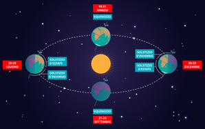
Solstizi ed equinozi
Didascalia: Questo diagramma illustra le posizioni relative della Terra e del Sole nei due solstizi e nei due equinozi. L'asse di rotazione della Terra è inclinato di 23,4° rispetto all'asse della sua orbita. Ciò significa che per metà dell'orbita annuale della Terra attorno al Sole, l'emisfero meridionale è inclinato verso il Sole, mentre l'emisfero settentrionale è inclinato nella direzione opposta. Durante questo periodo il Sole sembra trovarsi al di sotto dell'equatore celeste. Per questo motivo, in qualsiasi punto dell'emisfero meridionale, il Sole apparirà più alto sopra l'orizzonte in un determinato momento della giornata e le giornate saranno più lunghe. Al contrario, durante questo periodo, il Sole appare più basso nel cielo in qualsiasi momento della giornata nell'emisfero settentrionale e le giornate sono più corte.
Questo effetto è più pronunciato alla fine di dicembre, quando il Sole appare nel punto più meridionale del cielo, corrispondente al giorno più lungo dell'anno nell'emisfero meridionale. Ciò avviene normalmente il 21 o il 22 dicembre (UTC), a seconda di quando è stato l'ultimo anno bisestile, ma può verificarsi molto occasionalmente il 20 o il 23 dicembre. Questo evento è noto come solstizio di dicembre. Poiché in questo periodo i raggi del Sole colpiscono l'emisfero meridionale con un angolo più perpendicolare, l'emisfero meridionale è tipicamente più caldo in questo periodo dell'anno rispetto ad altri periodi. Questo periodo viene spesso definito estate nelle regioni temperate e antartiche dell'emisfero meridionale e quindi il solstizio di dicembre è noto come solstizio d'estate. A sud del Circolo Polare Antartico in questo periodo il Sole non tramonta mai e un Giorno Polare può durare diversi mesi. Al contrario, nell’emisfero settentrionale, i raggi del Sole colpiscono la Terra con un angolo più radente rispetto ad altri periodi dell’anno, quindi fa più freddo e questo solstizio è noto come solstizio d’inverno. A nord del Circolo Polare Artico il Sole non sorge mai in questo periodo e la Notte Polare può durare diversi mesi.
Con il passare dell'anno, la Terra si muove lungo la sua orbita e l'inclinazione dell'asse terrestre cambia, così da apparire più di profilo rispetto al Sole. Dal punto di vista di un osservatore sulla Terra, ciò significa che il Sole si sposta verso nord nel cielo, raggiungendo infine l'equatore celeste alla fine di marzo. Questo avviene solitamente il 20 marzo (UTC), ma a volte può verificarsi il 19 o il 21 marzo. Durante questo periodo, in tutti i luoghi della Terra si registreranno notti e giorni della durata di circa 12 ore. I raggi del Sole ora colpiscono l'emisfero meridionale con un angolo più obliquo rispetto a dicembre e l'emisfero settentrionale con un angolo più perpendicolare. Ciò significa che l'emisfero settentrionale si sarà riscaldato rispetto a dicembre, mentre quello meridionale si sarà raffreddato. Questo fa sì che l'equinozio di marzo sia chiamato equinozio d'autunno nell'emisfero meridionale ed equinozio di primavera nell'emisfero settentrionale.
Man mano che l'anno avanza, il Sole si sposta più a nord nel cielo, le giornate nell'emisfero settentrionale si allungano e quelle nell'emisfero meridionale si accorciano. A giugno l'orbita terrestre è progredita al punto in cui l'emisfero settentrionale è rivolto verso il Sole e l'emisfero meridionale è rivolto lontano dal Sole. In un momento compreso tra il 20 e il 22 giugno (UTC) il Sole raggiunge il suo punto più settentrionale nel cielo; questo fenomeno è noto come solstizio di giugno. Ora è estate nelle regioni temperate settentrionali e artiche, quindi questo è noto come solstizio d'estate nell'emisfero settentrionale e solstizio d'inverno nell'emisfero meridionale. Questo è il giorno più lungo dell'anno nell'emisfero settentrionale e il giorno più corto dell'anno nell'emisfero meridionale. Durante questo periodo, le regioni a nord del Circolo Polare Artico vivono un lungo giorno polare e le regioni a sud del Circolo Polare Antartico vivono la notte polare.
L'anno procede e la Terra si muove nella sua orbita, così che l'inclinazione dell'asse terrestre appare nuovamente di lato rispetto al Sole. Il Sole si sposta verso sud nel cielo e attraversa nuovamente l'equatore celeste tra il 21 e il 24 settembre (UTC). In questo momento, in tutti i luoghi della Terra la durata del giorno e della notte è uguale. Questo fenomeno è noto come equinozio di settembre, chiamato anche equinozio di primavera o vernal nell'emisfero meridionale ed equinozio d'autunno nell'emisfero settentrionale.
Si noti che le dimensioni della Terra, del Sole e dell'orbita terrestre attorno al Sole non sono in scala in questo diagramma.
Crediti: Maria Cristina Fortuna/IAU OAE
License: CC-BY-4.0 Creative Commons Attribuzione 4.0 Internazionale (CC BY 4.0) icone
Attività correlate
Why Do We Have Day and Night?
astroEDU educational activity (links to astroEDU website) Description: Explore day and night of Earth.
License: CC-BY-4.0 Creative Commons Attribuzione 4.0 Internazionale (CC BY 4.0) icone
Etichette:
Tilt
Fasce d'età
6-8
, 8-10
, 10-12
Livello di istruzione
Primary
, Secondary
Aree di apprendimento
Modelling
, Simulation focussed
, Structured-inquiry learning
Costi:
Low Cost
Durata:
1 hour 30 mins
Dimensione del Gruppo:
Group
Abilità:
Asking questions
, Communicating information

