This page describes an image Horizontal Coordinate System

Datei runterladen ( Bild 1.76 MB)
PDF Datei runterladen (PDF file 165.78 kB)
Also available in black and white
Datei runterladen ( Bild 483.06 kB)
PDF Datei runterladen (PDF file 136.70 kB)
Untertitel Diagramm:
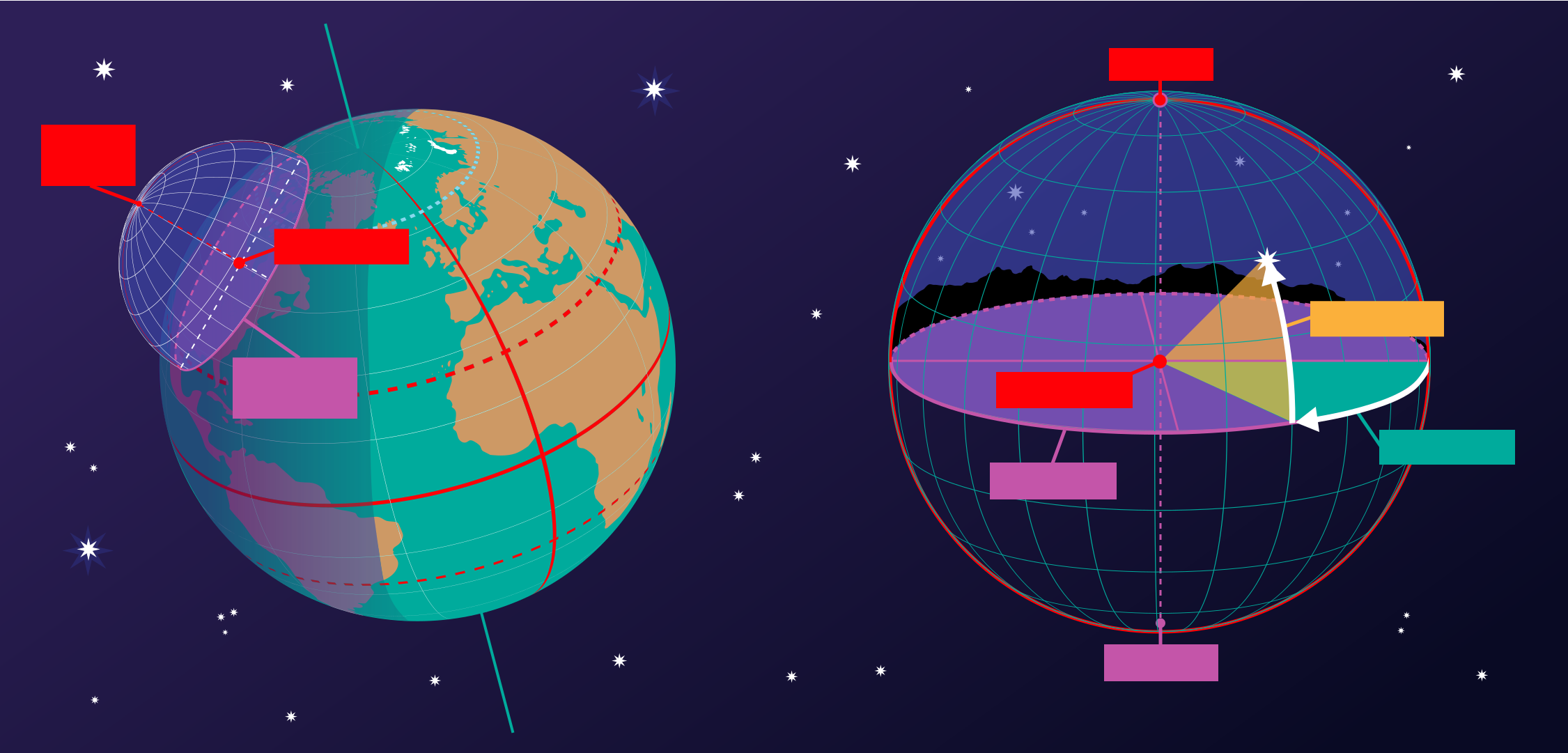
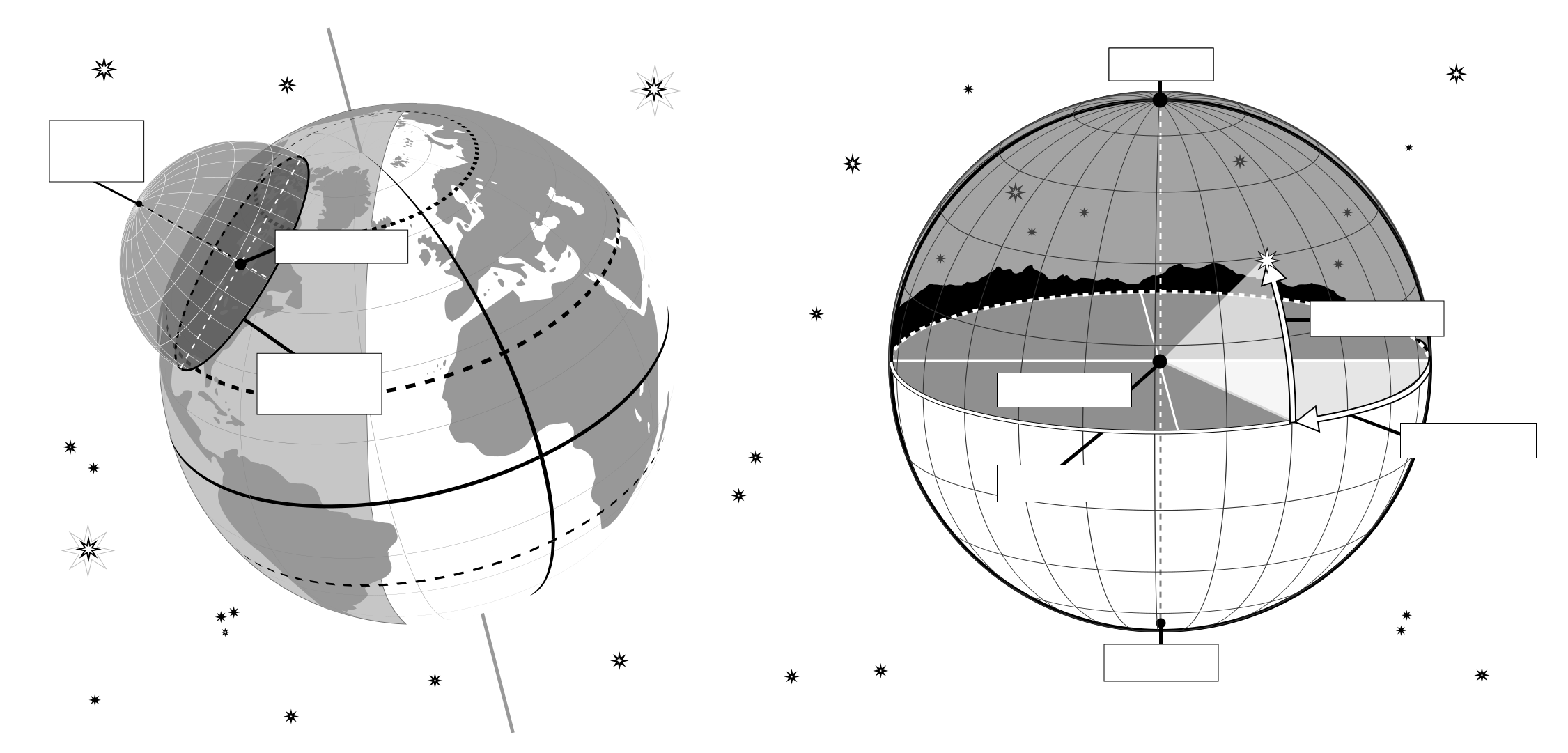
This image shows the horizontal coordinate system of an observer on Earth. On the right we see the coordinate system in the local context of the observer. The observer appears here as a point surrounded by the celestial sphere. The ground appears as a plane, while the Earth is round, we can approximate the ground in the area around the observer as a plane. The line where this plane intersects with the celestial sphere is the horizon. The point directly above the observer is the zenith, the point directly below the observer is the nadir which is hidden by the ground.
Two coordinates define this coordinate system, altitude and azimuth, hence the reason this sometimes called an alt-az coordinate system. The altitude is zero at the horizon, maximum (90°) at the zenith and minimum (-90°) at the nadir. Azimuth is the angle around the horizon. Most commonly this is defined to be zero in the direction of north. Any point on the celestial sphere can be defined by these two coordinates. However what objects appear on these position will depend on the time and the location of the observer.
On the left-hand part of the diagram, we can see that when we put the observer and their local horizontal coordinate system in a global context, that the parts of the sky the observer can see depend on their position on the Earth and on the rotation of the Earth. The zenith points perpendicular to the Earth's surface so the position on the sky the zenith and nadir correspond to is dependent on the observer's latitude. The horizon also depends on the observer's position on the Earth.
Quelle Diagramm: Maria Cristina Fortuna/IAU OAE.
Diagramm Übersetzungsstatus: Noch nicht bestätigt von einem Rezensenten
Diagramm-Lizenz: Creative Commons Namensnennung 4.0 International (CC BY 4.0) Creative Commons Namensnennung 4.0 International (CC BY 4.0) Symbole
Ähnliche Glossarbegriffe:
Azimut
, Horizont
, Höhe
, Nadir
, Zenit
Kategorien:
Astronomie mit bloßem Auge
, Beobachtende Astronomie
Möchtest du deine eigene Übersetzung oder Version dieses Diagrammes erstellen? Dann downloade die SVG
Version dieses Diagrammes auf Englisch (237.62 kB). Du kannst diese Version mit Programmen wie Inkscape (kostenlos) oder Adobe Illustrator (kostenpflichtig) bearbeiten. Bitte verweise dennoch auf den originalen Autor.
Also available in black and white ( Bild 237.62 kB).
Du kannst Deine eigene Version oder Übersetzung dieses Diagrammes erstellen, indem du einer textlosen Version dieses Diagrammes eigenen Text zufügst.
Downloade einfach eine dieser Dateien:
Download Text-Free File ( Bild 578.50 kB)
Download Text-Free PDF File (PDF file 175.90 kB)
Also available in black and white:
Download Text-Free File ( Bild 450.79 kB)
Download Text-Free PDF File (PDF file 141.72 kB)
Auf anderen Sprachen
Englisch: Horizontal Coordinate SystemItalienisch: Sistema di coordinate orizzontali
The diagram captions presented on the OAE website were written, translated and reviewed by a collective effort from the OAE, the OAE Centers and Nodes, the OAE National Astronomy Education Coordinators (NAECs) and other volunteers. You can find a full list of credits for our translation project here. All media file captions are released under a Creative Commons CC BY-4.0 license and should be credited to "IAU OAE". The media files themselves may have different licenses (see above) and should be credited as listed above under "credit".
Sollte dir ein Fehler in diesem Diagramm oder seiner Unterschrift auffallen, bitte kontaktiere uns.


