Glossar-Begriff: Äquator
Beschreibung: Der Äquator ist eine gedachte Linie, die um die Erde verläuft, gleich weit vom Nord- und Südpol entfernt ist und senkrecht zur Rotationsachse der Erde steht. Der Äquator ist die Linie auf der Erdoberfläche, die am weitesten von der Rotationsachse entfernt ist. An den Polen schneidet sich diese Rotationsachse mit der Erdoberfläche. Im Koordinatensystem für Breiten- und Längengrade auf der Erdoberfläche hat der Äquator die geografische Breite 0°. Der Äquator unterteilt die Erde in eine nördliche und eine südliche Halbkugel. Orte auf der nördlichen Hemisphäre haben eine positive geografische Breite, Orte auf der südlichen Hemisphäre eine negative geografische Breite.
Ähnliche Begriffe:
Dieser Begriff in anderen Sprachen
Begriffs- und Definitionsstatus Die Originaldefinition dieses Begriffes auf Englisch wurden von einem forschenden Astronom und einer Lehrkraft bestätigt Die Übersetzung dieses Begriffs und seiner Definition warten auf Prüfung und Bestätigung
The OAE Multilingual Glossary is a project of the IAU Office of Astronomy for Education (OAE) in collaboration with the IAU Office of Astronomy Outreach (OAO). The terms and definitions were chosen, written and reviewed by a collective effort from the OAE, the OAE Centers and Nodes, the OAE National Astronomy Education Coordinators (NAECs) and other volunteers. You can find a full list of credits here. All glossary terms and their definitions are released under a Creative Commons CC BY-4.0 license and should be credited to "IAU OAE".
Wenn dir ein inhaltlicher oder Übersetzungsfehler in diesem Glossarbegriff oder dieser Definition auffallen, bitte kontaktiere uns.
Ähnliche Medien

Der Nullmeridian
Unterschrift: Der Nullmeridian ist als null Grad Länge definiert und verläuft vom Nordpol über Greenwich in London bis zum Südpol. Auf dieser schematischen Weltkarte ist er als leuchtend rote Linie dargestellt. Die horizontale Linie markiert den Äquator, während der Antimeridian die äußeren Kartenränder bei 180 Grad westlicher und östlicher Länge bildet.
Bild: Wikicommons-Benutzer Kmf164
Quellenlink
License: PD Gemeinfrei Symbole
Ähnliche Diagramme

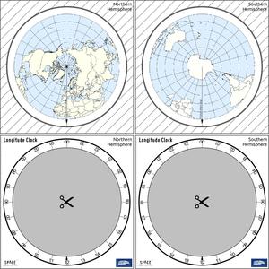
Latitude and Longitude
Unterschrift: Two views of the Earth, one viewing the Northern Hemisphere, one viewing the Southern Hemisphere. The Earth rotates around its axis, an imaginary line that runs through the Earth from the North Pole to the South Pole. The Equator is an imaginary line that is the same distant from both the North Pole and the South Pole.
The positions of two cities, Rome in the Northern Hemisphere and Sydney in the Southern Hemisphere are marked here with red dots. Arrows indicate the two spherical coordinates latitude and longitude.
Latitude marks the position north or south of the equator. Here we can see Rome has the letter N in its latitude as it is in the Northern Hemisphere and Sydney has the letter S in its latitude as it is in the Southern Hemisphere. Latitude can vary from 90° N at the North Pole to 0° at the Equator to 90° S at the South Pole.
Longitude measures the position around the equator. While the choice of the zero point for latitude as the equator seems obvious, the choice of the zero point for longitude is more subjective. By convention the zero point in longitude is the prime meridian which passes through the Royal Greenwich Observatory in the UK. This is marked here as a solid line originating at the North Pole. Longitude is measured in degrees east or west of the prime meridian. As both Rome and Sydney lie to the east of Greenwich, they have the letter E as part of their longitude. Moving west to east, longitude varies from 180° W on the other side of the world from the prime meridian to 0° on the prime meridian before reaching 180° E again on the other side of world from the prime meridian.
This diagram shows the Earth at the December solstice. Two views are presented, one viewing the Northern Hemisphere and one viewing the Southern Hemisphere about nine hours later. The shaded region shows the night side of the Earth, with the day side being lighter. As it is the December solstice, the Sun appears overhead at the Tropic of Capricorn. This is a line of constant latitude at 23°26′09.3″ S. Six months later, at the June solstice, the Sun will appear to be overhead at the Tropic of Cancer at 23°26′09.3″ N. As the Sun appears over the Tropic of Capricorn more of the Southern Hemisphere is illuminated than the Northern Hemisphere. Indeed below the Antarctic Circle (the Polar Circle around the South Pole) the Sun does not set at this time of year leading to a Polar Day. Conversely, north of the Arctic Circle (the Polar Circle around the North Pole) the Sun does not rise at this time of year, leading to a Polar Night.
Bild: Maria Cristina Fortuna/IAU OAE
License: CC-BY-4.0 Creative Commons Namensnennung 4.0 International (CC BY 4.0) Symbole

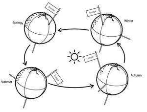
Seasons
Unterschrift: This diagram shows the Earth at the June solstice which is known as the summer solstice in the Northern Hemisphere and the winter solstice in the Southern Hemisphere. The Earth’s axis of rotation is tilted from the axis of the Earth’s orbit around the Sun by 23.4°. Here we see light from the sun represented as parallel lines, in the diagram the Sun would lie far off the right-hand edge. Five lines are marked with angles. These lines hit the Earth at special latitudes. From top to bottom these lines hit the Earth at the North Pole, the Tropic of Cancer, the Equator, the Tropic of Capricorn and the Antarctic Circle. The lines are shown hitting the Earth at the longitude where it is currently noon. For the last four lines, the angles marked show the angle above the horizon (the altitude) which the Sun appears in the sky at at local noon.
At the June solstice, the Sun will appear directly overhead at local noon on every point on the Tropic of Capricorn. By contrast the Sun reaches a maximum altitude of 0° at local noon on every point in the Antarctic Circle. This means the Sun never rises and every point south of the Antarctic Circle experiences a long Polar Night. By contrast the Sun never sets on this day north of the Arctic Circle and the regions here experience a Polar Day. The at the North Pole the Sun will remain at a constant altitude all day. This altitude will be the angle 180°-156.6° (23.4°).
The altitude the Sun appears at is important as it defines how spread out the Sun’s rays are on the Earth’s surface. Look at the thick, faint parallel lines in the background. Notice how at the Tropic of Cancer the area the lines intersect with the Earth’s surface perpendicularly and the line only covers a small part of the Earth’s surface. Now look at a line near the Tropic of Capricorn and see that this intersects with the Earth at a grazing angle and the line is spread out, covering a much wider area of the Earth’s surface. This means that a given amount of light from the Sun that hits the Tropic of Cancer is more concentrated and the same amount of light hitting the Tropic of Capricorn would be more spread out. This leads to more energy per unit area from the Sun hitting the Tropic of Cancer and less energy per unit area hitting the Tropic of Capricorn. This means it will be warmer at the Tropic of Cancer than at the Tropic of Capricorn. It is thus summer at the Tropic of Cancer and winter at the Tropic of Capricorn.
Six months later this situation will be reversed and it will be summer at the Tropic of Capricorn and winter at the Tropic of Cancer.
Bild: Maria Cristina Fortuna/IAU OAE
License: CC-BY-4.0 Creative Commons Namensnennung 4.0 International (CC BY 4.0) Symbole
Ähnliche Aktivitäten
Seasons Around the World
astroEDU educational activity (links to astroEDU website) Description: Demonstrate the seasons on Earth using a model.
License: CC-BY-4.0 Creative Commons Namensnennung 4.0 International (CC BY 4.0) Symbole
Schlagworte
Hands-on
, Model
Altersgruppen:
6-8
, 8-10
, 10-12
Bildungsniveau:
Middle School
, Primary
Lernbereiche:
Modelling
, Structured-inquiry learning
Kosten:
Medium Cost
Dauer:
45 mins
Gruppengröße:
Group
Fähigkeiten:
Analysing and interpreting data
, Asking questions
, Constructing explanations
, Developing and using models
, Planning and carrying out investigations
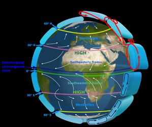
The Intertropical Convergence Zone
astroEDU educational activity (links to astroEDU website) Description: The air circulation system: how are winds created?
License: CC-BY-4.0 Creative Commons Namensnennung 4.0 International (CC BY 4.0) Symbole
Schlagworte
Climate
, Updraft
, Convection
, Winds
Altersgruppen:
12-14
, 14-16
Bildungsniveau:
Middle School
Lernbereiche:
Discussion Groups
, Modelling
, Structured-inquiry learning
Kosten:
Medium Cost
Dauer:
1 hour
Gruppengröße:
Group
Fähigkeiten:
Communicating information
, Constructing explanations
, Developing and using models
, Engaging in argument from evidence
, Planning and carrying out investigations
The Quest for Longitude
astroEDU educational activity (links to astroEDU website) Description: How to navigate at sea like an explorer?
License: CC-BY-4.0 Creative Commons Namensnennung 4.0 International (CC BY 4.0) Symbole
Schlagworte
Clocks
, Geography
, Coordinates
, Celestial navigation
, James Cook
, Exploration
Altersgruppen:
14-16
, 16-19
Bildungsniveau:
Middle School
, Secondary
Lernbereiche:
Discussion Groups
, Modelling
, Structured-inquiry learning
Kosten:
Low Cost
Dauer:
2 hours
Gruppengröße:
Group
Fähigkeiten:
Analysing and interpreting data
, Asking questions
, Communicating information
, Developing and using models
, Planning and carrying out investigations
, Using mathematics and computational thinking
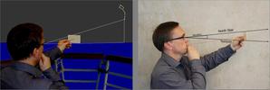
Navigating with the Kamal – Northern Hemisphere
astroEDU educational activity (links to astroEDU website) Description: How did Arabian sailors navigate at sea?
License: CC-BY-4.0 Creative Commons Namensnennung 4.0 International (CC BY 4.0) Symbole
Schlagworte
History
, Geography
, Coordinates
, Celestial navigation
, Arabia
, Kamal
Altersgruppen:
14-16
, 16-19
Bildungsniveau:
Middle School
, Secondary
Lernbereiche:
Modelling
, Structured-inquiry learning
Kosten:
Low Cost
Dauer:
1 hour 30 mins
Gruppengröße:
Group
Fähigkeiten:
Analysing and interpreting data
, Asking questions
, Communicating information
, Developing and using models
, Planning and carrying out investigations
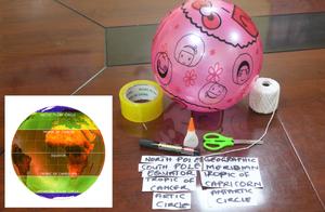
Discover Earth's climate with a balloon
astroEDU educational activity (links to astroEDU website) Description: Discover the secrets of Earth's climate zones with a hands-on experience
License: CC-BY-4.0 Creative Commons Namensnennung 4.0 International (CC BY 4.0) Symbole
Altersgruppen:
8-10
, 10-12
Bildungsniveau:
Middle School
, Primary
Lernbereiche:
Fun activity
, Guided-discovery learning
, Modelling
, Observation based
, Project-based learning
, Structured-inquiry learning
Kosten:
Low Cost
Dauer:
45 mins
Gruppengröße:
Group
Fähigkeiten:
Asking questions
, Constructing explanations
, Developing and using models

