This page describes an image SDSS Redshift Map
Descargar archivo ( imagen 507.35 kB)
Pie de foto:
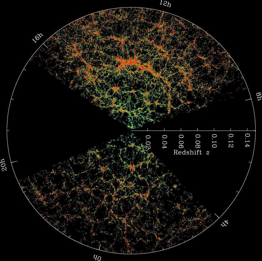
This image shows a map of the distribution of galaxies and is based on redshift data from the Sloan Digital Sky Survey (SDSS). Redshift measurements provides information on the distances, positions and motions of the galaxies.
The Earth is located at the center of the image, and each dot represents a galaxy. The outer circle represents a ""distance"" of about 2 billion light years. The idea of distance in cosmology is complex because the usual measurement of distance is the separation between two points in space at the same time. However, because of the speed of light, the further a distance, the farther back in time we are observing. The numbers on the outer circle are Right Ascension coordinates mapped onto a flat circle, and provides information on the position of the galaxies on the sky. The colours used represent the ages of the stars in the galaxies, the redder, more strongly clustered points represent galaxies comprising of older stars. The dark wedges that do not contain any dots are regions that were not mapped by the SDSS due to dust from the Milky Way galaxy obscuring the view.
Desplázate hasta los subtítulos en otros idiomas
Crédito de la imagen: M. Blanton and Sloan Digital Sky Survey Enlace del crédito
Términos relacionados del glosario:
Desplazamiento al rojo
, Materia oscura
Categorías:
Cosmología
Licencia de la imagen: Creative Commons Reconocimiento 4.0 Internacional (CC BY 4.0) Creative Commons Reconocimiento 4.0 Internacional (CC BY 4.0) íconos
Las descripciones de los archivos multimedia que aparecen en la página web de la OAE han sido redactadas, traducidas y revisadas gracias al esfuerzo conjunto de la OAE y los Centros y Nodos de la OAE, los Coordinadores Nacionales de Educación Astronómica (NAECs) y otros voluntarios. Puedes consultar la lista completa de los créditos de nuestro proyecto de traducción aquí. Todos los pies de foto de los archivos multimedia se publican bajo una Creative Commons CC BY-4.0 licencia y deben atribuirse a la "IAU OAE". Los propios archivos multimedia pueden tener diferentes licencias (véase más arriba) y deben citarse tal y como se indica en "credit".
Pies de foto en diferentes idiomas:
Pie de foto: এই চিত্রটি গ্যালাক্সিগুলির বিতরণের একটি মানচিত্র দেখায় এবং এটি স্লোন ডিজিটাল স্কাই সার্ভে (এসডিএসএস) থেকে প্রাপ্ত রেডশিফ্ট ডেটার উপর ভিত্তি করে। রেডশিফ্ট পরিমাপ গ্যালাক্সিগুলির দূরত্ব, অবস্থান এবং গতি সম্পর্কে তথ্য সরবরাহ করে।
পৃথিবী ছবিটির কেন্দ্রে অবস্থিত এবং প্রতিটি বিন্দু একটি গ্যালাক্সির প্রতিনিধিত্ব করে। বাইরের বৃত্তটি প্রায় ২ বিলিয়ন আলোকবর্ষের একটি ""দূরত্ব" উপস্থাপন করে। সৃষ্টিতত্ত্বে দূরত্বের ধারণাটি জটিল কারণ দূরত্বের স্বাভাবিক পরিমাপ হল একই সময়ে মহাকাশের দুটি বিন্দুর মধ্যে বিচ্ছেদ। যাইহোক, আলোর গতির কারণে, যত বেশি দূরত্ব, সময়ের সাথে তত বেশি পিছিয়ে আমরা পর্যবেক্ষণ করছি। বাইরের বৃত্তের সংখ্যাগুলি হল ডান অ্যাসেনশন স্থানাঙ্কগুলি একটি সমতল বৃত্তের উপর ম্যাপ করা, এবং আকাশে ছায়াপথগুলির অবস্থান সম্পর্কে তথ্য প্রদান করে। ব্যবহৃত রঙগুলি ছায়াপথের নক্ষত্রের বয়সের প্রতিনিধিত্ব করে, লালতর, আরও দৃঢ়ভাবে ক্লাস্টারযুক্ত বিন্দুগুলি পুরানো নক্ষত্রগুলির সমন্বয়ে গঠিত ছায়াপথগুলিকে প্রতিনিধিত্ব করে। যে গাঢ় ওয়েজগুলিতে কোনও বিন্দু নেই সেগুলি এমন অঞ্চল যা এসডিএসএস দ্বারা ম্যাপ করা হয়নি মিল্কিওয়ে গ্যালাক্সির ধূলিকণার কারণে দৃশ্যটিকে অস্পষ্ট করে।
Crédito de la imagen: এম. ব্লান্টন এবং স্লোয়ান ডিজিটাল স্কাই সার্ভে
Términos relacionados del glosario: Dark Matter , Redshift Estado de la traducción de los subtítulos: Aún no ha sido aprobado por un revisor o revisora
Traductores de las leyendas: Raktim Mukherjee
Pie de foto: Dieses Bild zeigt eine Karte der Verteilung von Galaxien und basiert auf Rotverschiebungsdaten aus der Sloan Digital Sky Survey (SDSS). Messungen der Rotverschiebung liefern Informationen über die Entfernungen, Positionen und Bewegungen der Galaxien.
Die Erde befindet sich in der Mitte des Bildes, und jeder Punkt steht für eine Galaxie. Der äußere Kreis steht für eine "Entfernung" von etwa 2 Milliarden Lichtjahren. Das Konzept der Entfernung in der Kosmologie ist komplex, denn die übliche Messung einer Entfernung ist der Abstand zwischen zwei Punkten im Raum zur gleichen Zeit. Aufgrund der Lichtgeschwindigkeit gilt jedoch: Je größer die Entfernung, desto weiter zurück schauen wir in die Vergangenheit. Die Zahlen auf dem äußeren Kreis sind die Koordinaten der Rektaszension, die auf einen flachen Kreis abgebildet werden und Informationen über die Position der Galaxien am Himmel liefern. Die verwendeten Farben stellen das Alter der Sterne in den Galaxien dar, die rötlicheren, stärker gehäuften Punkte stehen für Galaxien mit älteren Sternen. Die dunklen Keile, die keine Punkte enthalten, sind Regionen, die von der SDSS nicht kartiert wurden, weil der Staub der Milchstraße die Sicht verdeckt.
Crédito de la imagen: M. Blanton und Sloan Digital Sky Survey
Términos relacionados del glosario: Dunkle Materie , Rotverschiebung Estado de la traducción de los subtítulos: Aún no ha sido aprobado por un revisor o revisora
Traductores de las leyendas: Simon Kraus
Pie de foto: This image shows a map of the distribution of galaxies and is based on redshift data from the Sloan Digital Sky Survey (SDSS). Redshift measurements provides information on the distances, positions and motions of the galaxies.
The Earth is located at the center of the image, and each dot represents a galaxy. The outer circle represents a ""distance"" of about 2 billion light years. The idea of distance in cosmology is complex because the usual measurement of distance is the separation between two points in space at the same time. However, because of the speed of light, the further a distance, the farther back in time we are observing. The numbers on the outer circle are Right Ascension coordinates mapped onto a flat circle, and provides information on the position of the galaxies on the sky. The colours used represent the ages of the stars in the galaxies, the redder, more strongly clustered points represent galaxies comprising of older stars. The dark wedges that do not contain any dots are regions that were not mapped by the SDSS due to dust from the Milky Way galaxy obscuring the view.
Crédito de la imagen: M. Blanton and Sloan Digital Sky Survey
Términos relacionados del glosario: Dark Matter , Redshift
Pie de foto: Questa immagine mostra una mappa delle galassie basata sui dati di redshift della Sloan Digital Sky Survey (SDSS). Le misure di redshift forniscono informazioni sulle distanze, le posizioni e i moti delle galassie.
La Terra si trova al centro dell'immagine e ogni punto rappresenta una galassia. Il cerchio esterno rappresenta una "distanza" di circa 2 miliardi di anni luce. L'idea di distanza in cosmologia è complessa perché in genere per distanza intendiamo la separazione tra due punti nello spazio in uno stesso istante di tempo. Tuttavia, poiché la velocità della luce è limitata, più la distanza è grande, più indietro nel tempo stiamo osservando. I numeri sul cerchio esterno sono coordinate di Ascensione retta tracciate su un cerchio piatto e forniscono informazioni sulla posizione delle galassie nel cielo. I colori utilizzati rappresentano l'età delle stelle presenti nelle galassie; i punti più rossi, più fortemente raggruppati, rappresentano galassie composte da stelle più vecchie. I settori scuri che non contengono punti sono regioni che non è stato possibile osservare con l'SDSS a causa della polvere della Via Lattea che oscura la vista.
Crédito de la imagen: M. Blanton e Sloan Digital Sky Survey
Términos relacionados del glosario: Materia oscura , redshift Estado de la traducción de los subtítulos: Aprobado por un revisor o revisora
Traductores de las leyendas: Giuliana Giobbi, Valentina La Parola
Revisores de las leyendas: Rodolfo Canestrari
Pie de foto: 这幅图像显示了星系在宇宙中的分布,根据斯隆数字巡天(SDSS)的红移数据所绘制。红移测量提供了星系的距离、位置和运动信息。
地球位于图像中心,每个圆点代表一个星系。外圈代表约 20 亿光年的 "距离"。宇宙学中的距离概念非常复杂,因为通常测量距离的方法是空间两点在同一时间的距离。然而,由于光速的原因,距离越远,我们观测到的时间就越久远。外圈上的数字是映射到平面圆圈上的赤经坐标,提供了星系在天空中的位置信息。所使用的颜色代表了星系中恒星的年龄,颜色较红、聚集度较高的点代表了由较老恒星组成的星系。没有包含任何点的暗楔形区域由于银河系的尘埃遮挡了视线因此没有被 SDSS 绘制出来。
Crédito de la imagen: M.布兰顿和斯隆数字巡天
Términos relacionados del glosario: 暗物质 , 红移 Estado de la traducción de los subtítulos: Aún no ha sido aprobado por un revisor o revisora
Traductores de las leyendas: Lin Shijie
Pie de foto: 這幅圖像顯示了星系在宇宙中的分布,根據斯隆數字巡天(SDSS)的紅移數據所繪製。紅移測量提供了星系的距離、位置和運動信息。
地球位於圖像中心,每個圓點代表一個星系。外圈代表約 20 億光年的 "距離"。宇宙學中的距離概念非常復雜,因為通常測量距離的方法是空間兩點在同一時間的距離。然而,由於光速的原因,距離越遠,我們觀測到的時間就越久遠。外圈上的數字是映射到平面圓圈上的赤經坐標,提供了星系在天空中的位置信息。所使用的顏色代表了星系中恆星的年齡,顏色較紅、聚集度較高的點代表了由較老恆星組成的星系。沒有包含任何點的暗楔形區域由於銀河系的塵埃遮擋了視線因此沒有被 SDSS 繪製出來。
Crédito de la imagen: M.布蘭頓和斯隆數字巡天
Términos relacionados del glosario: 暗物質 , 紅移 Estado de la traducción de los subtítulos: Aún no ha sido aprobado por un revisor o revisora
Traductores de las leyendas: Una transcripción automática a partir de la traducción al chino simplificado realizada por -Lin Shijie