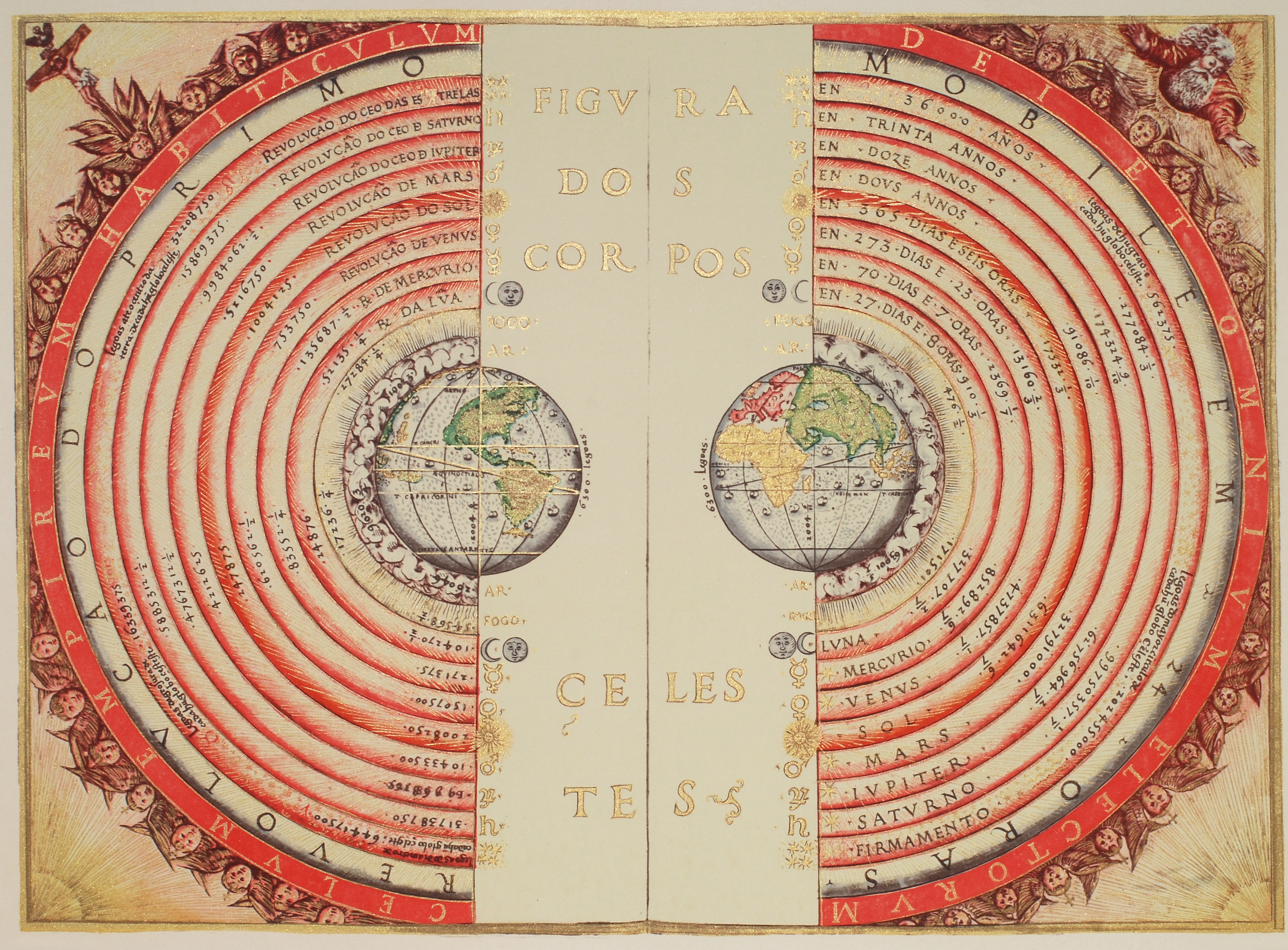
This page describes an image A Geocentric chart from 1568
شرح الصورة:
This map, created in 1568 by the Portuguese cartographer Bartolomeu Velho, depicts the worldview of the time, when many scholars believed in a geocentric model of the cosmos — the idea that Earth sits at the centre of the Universe with the Sun, Moon, the five planets known at the time, and stars moving around it. The design and layout of this map were influenced by astronomical understanding rooted in geocentric thinking.
The geocentric model was widely accepted for many centuries, especially in Europe, based on interpretations of celestial motions and philosophical traditions that placed Earth at the centre. It was only later, with observations by astronomers such as, Galileo Galilei, that this model was replaced by the heliocentric model, which places the Sun at the centre of the Solar System.
انتقل إلى الشروح بلغات أخرى
مصدر الصورة: Bartolomeu Velho رابط المصدر
شروح بلغات مختلفة:
شرح الصورة: Diese Darstellung, die 1568 vom portugiesischen Kartographen Bartolomeu Velho erstellt wurde, spiegelt das Weltbild jener Zeit wider, als viele Gelehrte an ein geozentrisches Weltbild glaubten. Dies ist die Vorstellung, dass die Erde im Zentrum des Universums steht, um die sich die Sonne, der Mond, die fünf damals bekannten Planeten und die Sterne herum bewegen. Obwohl es sich in erster Linie um eine Navigationskarte handelt, wurden Gestaltung und Aufbau dieser Karte von astronomischen Erkenntnissen beeinflusst, die im geozentrischen Denken verwurzelt waren.
Das geozentrische Weltbild war über viele Jahrhunderte hinweg insbesondere in Europa weit verbreitet und basierte auf Interpretationen der Himmelsbewegungen sowie auf philosophischen Traditionen, die die Erde in den Mittelpunkt stellten. Erst später, durch Beobachtungen von Astronomen wie Galileo Galilei, wurde dieses Modell durch das heliozentrische Modell abgelöst, das die Sonne in den Mittelpunkt des Sonnensystems stellt.
مصدر الصورة: Bartolomeu Velho
مصطلحات معجم ذات صلة: Geozentrisches Modell , Wissenschaftliches Modell حالة ترجمة الشرح: لم تتم الموافقة من قبل مُراجع بعد
مترجمو الشروح: Simon Kraus
شرح الصورة: This map, created in 1568 by the Portuguese cartographer Bartolomeu Velho, depicts the worldview of the time, when many scholars believed in a geocentric model of the cosmos — the idea that Earth sits at the centre of the Universe with the Sun, Moon, the five planets known at the time, and stars moving around it. The design and layout of this map were influenced by astronomical understanding rooted in geocentric thinking.
The geocentric model was widely accepted for many centuries, especially in Europe, based on interpretations of celestial motions and philosophical traditions that placed Earth at the centre. It was only later, with observations by astronomers such as, Galileo Galilei, that this model was replaced by the heliocentric model, which places the Sun at the centre of the Solar System.
مصدر الصورة: Bartolomeu Velho
مصطلحات معجم ذات صلة: Geocentric Model , Scientific Model
شرح الصورة: Este mapa, realizado en 1568 por el cartógrafo portugués Bartolomeu Velho, refleja la visión del mundo de la época, en la que muchos eruditos creían en un modelo geocéntrico del cosmos —la idea de que la Tierra se encuentra en el centro del universo y que el Sol, la Luna, los cinco planetas conocidos en aquel entonces y las estrellas giran a su alrededor—. Aunque se trata principalmente de una carta de navegación, el diseño y la disposición de este mapa se vieron influidos por los conocimientos astronómicos arraigados en el pensamiento geocéntrico.
El modelo geocéntrico fue ampliamente aceptado durante muchos siglos, especialmente en Europa, basándose en interpretaciones de los movimientos celestes y tradiciones filosóficas que situaban a la Tierra en el centro. No fue hasta más tarde, con las observaciones de astrónomos como Galileo Galilei, que este modelo fue sustituido por el modelo heliocéntrico, que sitúa al Sol en el centro del Sistema Solar.
مصدر الصورة: Bartolomeu Velho
مصطلحات معجم ذات صلة: Modelo científico , Modelo geocéntrico حالة ترجمة الشرح: لم تتم الموافقة من قبل مُراجع بعد
مترجمو الشروح: Aurelia Teresa Gallego Calvente
شرح الصورة: Questa mappa, realizzata nel 1568 dal cartografo portoghese Bartolomeu Velho, riflette la visione del mondo dell’epoca, quando molti studiosi credevano in un modello geocentrico del cosmo — l’idea che la Terra fosse al centro dell’Universo, con il Sole, la Luna, i cinque pianeti allora conosciuti e le stelle che le ruotavano attorno. Il disegno e la struttura di questa mappa furono influenzati dalla comprensione astronomica radicata nel pensiero geocentrico.
Il modello geocentrico è stato ampiamente accettato per molti secoli, specialmente in Europa, sulla base delle interpretazioni dei moti celesti e delle tradizioni filosofiche che collocavano la Terra al centro. Solo più tardi, grazie alle osservazioni di astronomi come Galileo Galilei, questo modello è stato sostituito dal modello eliocentrico, che pone il Sole al centro del Sistema Solare.
مصدر الصورة: Bartolomeu Velho
مصطلحات معجم ذات صلة: Modello geocentrico , Modello scientifico حالة ترجمة الشرح: لم تتم الموافقة من قبل مُراجع بعد
مترجمو الشروح: Giuliana Giobbi
شرح الصورة: Este mapa, criado em 1568 pelo cartógrafo português Bartolomeu Velho, retrata a visão de mundo da época, quando muitos estudiosos acreditavam num modelo geocêntrico do cosmos — a ideia de que a Terra se situava no centro do Universo, com o Sol, a Lua, os cinco planetas conhecidos na época e as estrelas girando ao seu redor. O desenho e a organização deste mapa foram influenciados pelo entendimento astronômico enraizado no pensamento geocêntrico.
O modelo geocêntrico foi amplamente aceito por muitos séculos, especialmente na Europa, com base em interpretações dos movimentos celestes e tradições filosóficas que colocavam a Terra no centro. Foi somente mais tarde, com observações alizadas por astrônomos como Galileu Galilei, que esse modelo foi substituído pelo modelo heliocêntrico, que coloca o Sol no centro do Sistema Solar.
مصدر الصورة: Bartolomeu Velho
مصطلحات معجم ذات صلة: Modelo científico , Modelo geocêntrico حالة ترجمة الشرح: لم تتم الموافقة من قبل مُراجع بعد
مترجمو الشروح: Eduardo Monfardini Penteado

