Termine del Glossario Satellite artificiale
Descrizione Un satellite artificiale è un dispositivo costruito dall'uomo che viene inviato nello spazio per orbitare intorno alla Terra o ad altri oggetti del Sistema Solare, dove la gravità lo mantiene in orbita. I satelliti artificiali possono essere costruiti per svolgere diversi compiti, tra cui scattare fotografie aeree della Terra che aiutano i meteorologi a prevedere il tempo, o scattare immagini di corpi astronomici e galassie lontane, che aiutano gli scienziati a comprendere meglio il sistema cosmico. I satelliti artificiali sono anche utilizzati principalmente per le comunicazioni in tutto il mondo, come ad esempio il Global Positioning System (GPS). Il primo satellite artificiale è stato lanciato nello spazio nel 1957 dall'Unione Sovietica, con il nome di Sputnik 1.
Termini correlati
Vedi questo termine in altre lingue
status del termine e della definizione La definizione originale di questo termine in inglese é stata approvata da un ricercatore astronomo e da un docente La traduzione di questo termine e della sua definizione sono state approvate da un ricercatore astronomo e da un docente
Il Glossario Multilingue OAE é un progetto dell'Ufficio IAU per la didatticadell'astronomia (OAE) in collaborazione con l'ufficio IAU OAO per la DivulgazioneAstronomica (OAO). I termini e le definizioni sono stater scelte, scritte eriviste da un impegno collettivo da parte di OAE, i Centri e i Nodi OAE e iCoordinatori Nazionali per la Didattica dell'Astronomia e da altri volontari.Potete trovare una lista completa dei crediti, Tutti i termini del glossarioE le definizioni sono pubblicate su Creative Commons CC BY-4.0 licenza e dovrebbero essere accreditate ad IAU OAE.
Se noti un errore di fatto o di traduzione in questo termine del glossario, per favore contattaci.
In Altre Lingue
- Arabo: قمر اصطناعي
- Tedesco: Künstlicher Satellit
- Inglese: Artificial Satellite
- Spagnolo: Satélite Artificial
- Francese: Satellite artificiel
- Hindi: कृत्रिम उपग्रह
- Giapponese: 人工衛星 (external link)
- Coreano: 인공 위성
- Marathi: कृत्रिम उपग्रह
- Brasiliano Portoghese: Satélite artificial
- Cinese semplificato: 人造卫星
- Cinese tradizionale: 人造衛星
File multimediali correlati
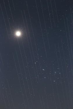
Sciame di satelliti contrapposti alla bellezza del cielo notturno, di Torsten Hansen, Germania
Didascalia: Terzo posto al concorso di astrofotografia IAU OAE 2021, categoria Inquinamento luminoso.
Questa immagine di Venere e delle Pleiadi mostra anche le tracce dei satelliti Starlink. Questi satelliti, che si trovano a un'altitudine di circa 550 chilometri, fanno parte di una costellazione di satelliti in continua crescita che mira a fornire accesso a Internet in tutto il mondo. Le superfici riflettenti dei satelliti, unite al fatto che i satelliti orbitano intorno alla Terra, fanno sì che le immagini ottenute in osservazioni astronomiche che richiedono esposizioni molto lunghe catturino le "scie" dei satelliti nelle loro immagini. Le immagini astronomiche destinate alla ricerca scientifica non sono utilizzabili perché le misure e i dati contengono queste "scie". Poiché si prevede che il numero di satelliti crescerà, è probabile che nel prossimo futuro non ci sarà luogo sulla Terra in cui questi satelliti non saranno visibili mentre attraversano il cielo. Si tratta di un nuovo tipo d'inquinamento luminoso con cui dovremo fare i conti, poiché questi satelliti potrebbero impedire un'osservazione ottimale del cielo.
Crediti: Torsten Hansen/IAU OAE
License: CC-BY-4.0 Creative Commons Attribuzione 4.0 Internazionale (CC BY 4.0) icone
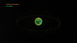
Rifiuti spaziali in orbita attorno alla Terra
Didascalia: Questa animazione mostra gli oggetti in orbita attorno alla Terra. I dati risalgono al febbraio 2024 e sono tratti dal sito space-track.org, che gestisce un catalogo pubblico degli oggetti monitorati dallo United States Space Command (USSPACECOM).
All'inizio del video si vedono dei punti verdi, ciascuno dei quali rappresenta uno dei 31.000 oggetti di origine antropica in orbita attorno alla Terra. Tra questi figurano sia satelliti operativi che dismessi, stadi di razzi usati provenienti da lanci spaziali e frammenti di dimensioni superiori a 10 cm generati da collisioni o esplosioni. Più avanti nel video, alcuni dei punti verdi vengono sostituiti da punti arancioni, ciascuno dei quali rappresenta uno dei 9.300 satelliti operativi in orbita attorno alla Terra. Si noti che, dal febbraio 2024, sono stati lanciati nello spazio altri satelliti e razzi e alcuni oggetti saranno ricaduti sulla Terra, quindi questi numeri saranno cambiati.
Si osservano due gruppi principali di oggetti. Il primo è costituito dagli oggetti che orbitano vicino alla Terra, ovvero quelli in orbita terrestre bassa. Tra questi figurano i satelliti di comunicazione (molti dei quali appartenenti alle costellazioni utilizzate per fornire servizi Internet via satellite), i satelliti di osservazione della Terra, i satelliti militari, due stazioni spaziali operative e altri oggetti, come stadi di razzi e detriti vari.
Più lontano dalla Terra si osserva un sottile anello di satelliti. Questi si trovano in orbita geostazionaria. Si tratta di un’orbita speciale in cui il periodo orbitale corrisponde al periodo di rotazione della Terra. Ciò significa che un satellite in orbita geostazionaria rimane sopra lo stesso punto sull’equatore e, se osservato dal lato della Terra rivolto verso il satellite, sembrerà rimanere in una posizione nel cielo che non cambia nel tempo. Per questo motivo, l’orbita geostazionaria è utilizzata da molti satelliti di comunicazione, poiché un’antenna parabolica sulla Terra, utilizzata per ricevere o trasmettere un segnale a quel satellite, può essere orientata in una direzione fissa e non ha bisogno di seguire dinamicamente il satellite. L’orbita geostazionaria è utilizzata anche dai satelliti di osservazione meteorologica.
Crediti: Studio di visualizzazione scientifica della NASA
link ai crediti
License: PD Dominio Pubblico icone
Attività correlate
Valleys Deep and Mountains High
astroEDU educational activity (links to astroEDU website) Description: Learn how radar altimetry from satellites works and how to put landscapes on paper.
License: CC-BY-4.0 Creative Commons Attribuzione 4.0 Internazionale (CC BY 4.0) icone
Etichette:
Maps
, Earth observation
, Sentinel
, Copernicus
, Remote sensing
, Altimetry
, Radar
Fasce d'età
14-16
, 16-19
Livello di istruzione
Middle School
, Secondary
Aree di apprendimento
Discussion Groups
, Modelling
, Structured-inquiry learning
Costi:
Medium Cost
Durata:
2 hours
Dimensione del Gruppo:
Group
Abilità:
Analysing and interpreting data
, Asking questions
, Communicating information
, Developing and using models
, Using mathematics and computational thinking
A View from Above
astroEDU educational activity (links to astroEDU website) Description: How do satellites take images of the Earth surface and how do we analyse and use them?
License: CC-BY-4.0 Creative Commons Attribuzione 4.0 Internazionale (CC BY 4.0) icone
Etichette:
Maps
, Climate
, Landsat
, Earth observation
, Sentinel
, Copernicus
, Remote sensing
, Vegetation
Fasce d'età
14-16
, 16-19
Livello di istruzione
Middle School
, Secondary
Aree di apprendimento
Structured-inquiry learning
Costi:
Low Cost
Durata:
1 hour 30 mins
Dimensione del Gruppo:
Group
Abilità:
Analysing and interpreting data
, Asking questions
, Communicating information
, Constructing explanations
, Developing and using models
, Engaging in argument from evidence
, Using mathematics and computational thinking
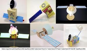
Build Your Own Artificial Satellite
astroEDU educational activity (links to astroEDU website) Description: Build a satellite to learn what they are made of and their uses.
License: CC-BY-4.0 Creative Commons Attribuzione 4.0 Internazionale (CC BY 4.0) icone
Etichette:
Art
, Creativity
, Hands-on
, Model
Fasce d'età
8-10
Livello di istruzione
Primary
Aree di apprendimento
Discussion Groups
, Interactive Lecture
, Modelling
Costi:
Low Cost
Durata:
1 hour 30 mins
Dimensione del Gruppo:
Group
Abilità:
Communicating information
, Developing and using models
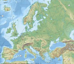
Where on Earth am I?
astroEDU educational activity (links to astroEDU website) Description: How do satellite-based positioning and GPS navigation work?
License: CC-BY-4.0 Creative Commons Attribuzione 4.0 Internazionale (CC BY 4.0) icone
Etichette:
Clocks
, Geography
, Maps
, GPS
, Countries
, Speed of light
, Galileo
Fasce d'età
14-16
Livello di istruzione
Middle School
Aree di apprendimento
Guided-discovery learning
, Problem-solving
Costi:
Low Cost
Durata:
1 hour 30 mins
Dimensione del Gruppo:
Group
Abilità:
Analysing and interpreting data
, Asking questions
, Communicating information
, Constructing explanations
, Developing and using models
, Using mathematics and computational thinking

