Glossary term: Artificial Satellite
Description: An artificial satellite is a human-made device that is sent into space, to orbit Earth or other Solar System objects, where gravity keeps it in orbit. Artificial satellites can be built to perform various tasks including taking aerial photographs of Earth that help meteorologists predict the weather, or taking pictures of astronomical bodies and distant galaxies, which helps scientists to better understand the cosmic system. Artificial satellites are also used primarily for communications around the world and for finding one's position, e.g. the Global Positioning System (GPS). The first artificial satellite was launched into space in 1957 by the Soviet Union, and it was called Sputnik 1.
Related Terms:
See this term in other languages
Term and definition status: This term and its definition have been approved by a research astronomer and a teacher
The OAE Multilingual Glossary is a project of the IAU Office of Astronomy for Education (OAE) in collaboration with the IAU Office of Astronomy Outreach (OAO). The terms and definitions were chosen, written and reviewed by a collective effort from the OAE, the OAE Centers and Nodes, the OAE National Astronomy Education Coordinators (NAECs) and other volunteers. You can find a full list of credits here. All glossary terms and their definitions are released under a Creative Commons CC BY-4.0 license and should be credited to "IAU OAE".
If you notice a factual error in this glossary definition then please get in touch.
In Other Languages
- Arabic: قمر اصطناعي
- German: Künstlicher Satellit
- Spanish: Satélite Artificial
- French: Satellite artificiel
- Hindi: कृत्रिम उपग्रह
- Italian: Satellite artificiale
- Japanese: 人工衛星 (external link)
- Korean: 인공 위성
- Marathi: कृत्रिम उपग्रह
- Brazilian Portuguese: Satélite artificial
- Simplified Chinese: 人造卫星
- Traditional Chinese: 人造衛星
Related Media
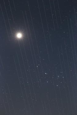
Satellite swarm versus night sky beauty, by Torsten Hansen, Germany
Caption: Third place in the 2021 IAU OAE Astrophotography Contest, category Light pollution.
This image of Venus and the Pleiades also shows the tracks of the Starlink satellites. These satellites which are located at an altitude of approximately 550 kilometres, are part of an ever-growing constellation of satellites aimed to provide worldwide internet access. The reflective surfaces of the satellites, coupled with the fact that they are orbiting around the Earth, means that astronomical observations which require very long exposures capture “tracks” of the satellites in their images. Astronomical images used for scientific research are not usable because the measurements and data will contain these “tracks”. Because the number of satellites is expected to grow, it is likely that in the near future there will be no place on Earth where these satellites will not be visible crossing the sky. This is a new type of light pollution that seems to be an upcoming problem we will have to deal with, as these satellites might prevent optimal observation of the sky.
Credit: Torsten Hansen/IAU OAE
License: CC-BY-4.0 Creative Commons Attribution 4.0 International (CC BY 4.0) icons
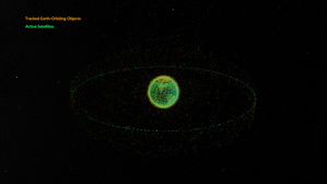
Space debris orbiting the Earth
Caption: This animation shows objects orbiting the Earth. The data date from February 2024 and are taken from space-track.org which maintains a public catalogue of objects tracked by the United States Space Command (USSPACECOM).
At first in this video we see green dots, each representing one of the 31,000 human-made objects orbiting Earth. These include both operational and decommissioned satellites, used rocket stages from space launches, and fragments larger than 10cm created by collisions or explosions. Later in the video, some of the green dots are replace by orange dots, each of these representing one of the 9,300 operational satellites orbiting the Earth. Note that since February 2024 more satellites and rockets have been launched in to space and some objects will have fallen back to Earth, so these numbers will have changed.
We see two main groups of objects. The first are those objects orbiting close to the Earth, objects in low Earth orbit. These include communication satellites (many from the satellite constellations used to provide satellite internet services), Earth observation satellites, military satellites, two operational space stations and other objects such as rocket stages and other debris.
More distant from Earth we see a thin ring of satellites. These are in geostationary orbit. This is a special orbit where the orbital period matches the rotation period of the Earth. This means that a satellite in geostationary orbit stays above the same point on the equator and, when observed from the side of the Earth facing the satellite, will appear to stay at a position on the sky that does not change over time. Because of this, geostationary orbit is used by many communications satellites as a satellite dish on Earth used to receive or transmit a signal to that satellite can point in a fixed direction and does not need to dynamically track the satellite. Geostationary orbit is also used by weather observation satellites.
Credit: NASA's Scientific Visualization Studio
credit link
License: PD Public Domain icons
Related Activities
Valleys Deep and Mountains High
astroEDU educational activity (links to astroEDU website) Description: Learn how radar altimetry from satellites works and how to put landscapes on paper.
License: CC-BY-4.0 Creative Commons Attribution 4.0 International (CC BY 4.0) icons
Tags:
Maps
, Earth observation
, Sentinel
, Copernicus
, Remote sensing
, Altimetry
, Radar
Age Ranges:
14-16
, 16-19
Education Level:
Middle School
, Secondary
Areas of Learning:
Discussion Groups
, Modelling
, Social Research
Costs:
Medium Cost
Duration:
2 hours
Group Size:
Group
Skills:
Analysing and interpreting data
, Asking questions
, Communicating information
, Developing and using models
, Using mathematics and computational thinking
A View from Above
astroEDU educational activity (links to astroEDU website) Description: How do satellites take images of the Earth surface and how do we analyse and use them?
License: CC-BY-4.0 Creative Commons Attribution 4.0 International (CC BY 4.0) icons
Tags:
Maps
, Climate
, Landsat
, Earth observation
, Sentinel
, Copernicus
, Remote sensing
, Vegetation
Age Ranges:
14-16
, 16-19
Education Level:
Middle School
, Secondary
Areas of Learning:
Social Research
Costs:
Low Cost
Duration:
1 hour 30 mins
Group Size:
Group
Skills:
Analysing and interpreting data
, Asking questions
, Communicating information
, Constructing explanations
, Developing and using models
, Engaging in argument from evidence
, Using mathematics and computational thinking
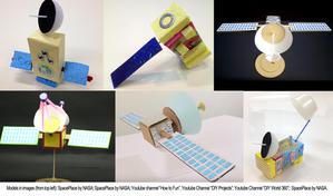
Build Your Own Artificial Satellite
astroEDU educational activity (links to astroEDU website) Description: Build a satellite to learn what they are made of and their uses.
License: CC-BY-4.0 Creative Commons Attribution 4.0 International (CC BY 4.0) icons
Tags:
Art
, Creativity
, Hands-on
, Model
Age Ranges:
8-10
Education Level:
Primary
Areas of Learning:
Discussion Groups
, Interactive Lecture
, Modelling
Costs:
Low Cost
Duration:
1 hour 30 mins
Group Size:
Group
Skills:
Communicating information
, Developing and using models
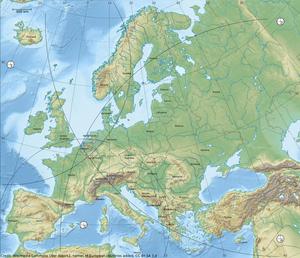
Where on Earth am I?
astroEDU educational activity (links to astroEDU website) Description: How do satellite-based positioning and GPS navigation work?
License: CC-BY-4.0 Creative Commons Attribution 4.0 International (CC BY 4.0) icons
Tags:
Clocks
, Geography
, Maps
, GPS
, Countries
, Speed of light
, Galileo
Age Ranges:
14-16
Education Level:
Middle School
Areas of Learning:
Guided-discovery learning
, Problem-solving
Costs:
Low Cost
Duration:
1 hour 30 mins
Group Size:
Group
Skills:
Analysing and interpreting data
, Asking questions
, Communicating information
, Constructing explanations
, Developing and using models
, Using mathematics and computational thinking

