Glossar-Begriff: Künstlicher Satellit
Beschreibung: Ein künstlicher Satellit ist ein vom Menschen geschaffenes Gerät, das in den Weltraum geschickt wird, um die Erde oder andere Objekte des Sonnensystems zu umkreisen, wo die Schwerkraft es in der Umlaufbahn hält. Künstliche Satelliten können für verschiedene Zwecke gebaut werden: z. B. für die Aufnahme von Luftaufnahmen der Erde, die Meteorologen bei der Wettervorhersage helfen, oder für die Aufnahme von Bildern astronomischer Körper und entfernter Galaxien. Künstliche Satelliten werden hauptsächlich auch für die weltweite Kommunikation und zur Positionsbestimmung eingesetzt, z. B. mit Satellitennavigationssystemen wie dem Global Positioning System (GPS). Der erste künstliche Satellit wurde 1957 von der Sowjetunion ins All geschickt und trug den Namen Sputnik 1.
Ähnliche Begriffe:
Dieser Begriff in anderen Sprachen
Begriffs- und Definitionsstatus Die Originaldefinition dieses Begriffes auf Englisch wurden von einem forschenden Astronom und einer Lehrkraft bestätigt Die Übersetzung dieses Begriffs und seiner Definition warten auf Prüfung und Bestätigung
The OAE Multilingual Glossary is a project of the IAU Office of Astronomy for Education (OAE) in collaboration with the IAU Office of Astronomy Outreach (OAO). The terms and definitions were chosen, written and reviewed by a collective effort from the OAE, the OAE Centers and Nodes, the OAE National Astronomy Education Coordinators (NAECs) and other volunteers. You can find a full list of credits here. All glossary terms and their definitions are released under a Creative Commons CC BY-4.0 license and should be credited to "IAU OAE".
Wenn dir ein inhaltlicher oder Übersetzungsfehler in diesem Glossarbegriff oder dieser Definition auffallen, bitte kontaktiere uns.
Auf anderen Sprachen
- Arabisch: قمر اصطناعي
- Englisch: Artificial Satellite
- Spanisch: Satélite Artificial
- Französisch: Satellite artificiel
- Hindi: कृत्रिम उपग्रह
- Italienisch: Satellite artificiale
- Japanisch: 人工衛星 (externer Link)
- Koreanisch: 인공 위성
- Marathi: कृत्रिम उपग्रह
- Brasilianisches Portugiesisch: Satélite artificial
- Vereinfachtes Chinesisch: 人造卫星
- Traditionelles Chinesisch: 人造衛星
Ähnliche Medien
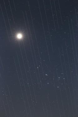
Satellitenschwarm versus Schönheit des Nachthimmels, von Torsten Hansen, Deutschland
Unterschrift: Dritter Platz beim IAU OAE Astrophotographie-Wettbewerb 2021, Kategorie Lichtverschmutzung.
Dieses Bild von Venus und den Plejaden zeigt auch die Spuren der Starlink-Satelliten. Diese Satelliten, die sich in einer Höhe von etwa 550 Kilometern befinden, sind Teil einer immer größer werdenden Satellitenkonstellation, die einen weltweiten Internetzugang ermöglichen soll. Die reflektierenden Oberflächen der Satelliten und die Tatsache, dass sie um die Erde kreisen, führen dazu, dass astronomische Beobachtungen, die sehr lange Belichtungszeiten erfordern, "Spuren" der Satelliten in ihren Bildern einfangen. Astronomische Bilder, die für die wissenschaftliche Forschung verwendet werden, sind unbrauchbar, da die Messungen und Daten diese "Spuren" enthalten. Da die Zahl der Satelliten voraussichtlich zunehmen wird, wird es wahrscheinlich in naher Zukunft keinen Ort auf der Erde mehr geben, an dem diese Satelliten nicht über den Himmel ziehen. Dies ist eine neue Art von Lichtverschmutzung, mit der wir uns in Zukunft auseinandersetzen müssen, da diese Satelliten eine optimale Beobachtung des Himmels verhindern könnten.
Bild: Torsten Hansen/IAU OAE
License: CC-BY-4.0 Creative Commons Namensnennung 4.0 International (CC BY 4.0) Symbole
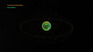
Space debris orbiting the Earth
Unterschrift: This animation shows objects orbiting the Earth. The data date from February 2024 and are taken from space-track.org which maintains a public catalogue of objects tracked by the United States Space Command (USSPACECOM).
At first in this video we see green dots, each representing one of the 31,000 human-made objects orbiting Earth. These include both operational and decommissioned satellites, used rocket stages from space launches, and fragments larger than 10cm created by collisions or explosions. Later in the video, some of the green dots are replace by orange dots, each of these representing one of the 9,300 operational satellites orbiting the Earth. Note that since February 2024 more satellites and rockets have been launched in to space and some objects will have fallen back to Earth, so these numbers will have changed.
We see two main groups of objects. The first are those objects orbiting close to the Earth, objects in low Earth orbit. These include communication satellites (many from the satellite constellations used to provide satellite internet services), Earth observation satellites, military satellites, two operational space stations and other objects such as rocket stages and other debris.
More distant from Earth we see a thin ring of satellites. These are in geostationary orbit. This is a special orbit where the orbital period matches the rotation period of the Earth. This means that a satellite in geostationary orbit stays above the same point on the equator and, when observed from the side of the Earth facing the satellite, will appear to stay at a position on the sky that does not change over time. Because of this, geostationary orbit is used by many communications satellites as a satellite dish on Earth used to receive or transmit a signal to that satellite can point in a fixed direction and does not need to dynamically track the satellite. Geostationary orbit is also used by weather observation satellites.
Bild: NASA's Scientific Visualization Studio
Quellenlink
License: PD Gemeinfrei Symbole
Ähnliche Aktivitäten
Valleys Deep and Mountains High
astroEDU educational activity (links to astroEDU website) Description: Learn how radar altimetry from satellites works and how to put landscapes on paper.
License: CC-BY-4.0 Creative Commons Namensnennung 4.0 International (CC BY 4.0) Symbole
Schlagworte
Maps
, Earth observation
, Sentinel
, Copernicus
, Remote sensing
, Altimetry
, Radar
Altersgruppen:
14-16
, 16-19
Bildungsniveau:
Middle School
, Secondary
Lernbereiche:
Discussion Groups
, Modelling
, Structured-inquiry learning
Kosten:
Medium Cost
Dauer:
2 hours
Gruppengröße:
Group
Fähigkeiten:
Analysing and interpreting data
, Asking questions
, Communicating information
, Developing and using models
, Using mathematics and computational thinking
A View from Above
astroEDU educational activity (links to astroEDU website) Description: How do satellites take images of the Earth surface and how do we analyse and use them?
License: CC-BY-4.0 Creative Commons Namensnennung 4.0 International (CC BY 4.0) Symbole
Schlagworte
Maps
, Climate
, Landsat
, Earth observation
, Sentinel
, Copernicus
, Remote sensing
, Vegetation
Altersgruppen:
14-16
, 16-19
Bildungsniveau:
Middle School
, Secondary
Lernbereiche:
Structured-inquiry learning
Kosten:
Low Cost
Dauer:
1 hour 30 mins
Gruppengröße:
Group
Fähigkeiten:
Analysing and interpreting data
, Asking questions
, Communicating information
, Constructing explanations
, Developing and using models
, Engaging in argument from evidence
, Using mathematics and computational thinking
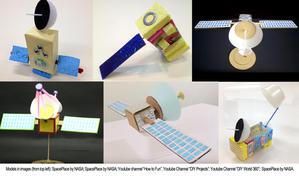
Build Your Own Artificial Satellite
astroEDU educational activity (links to astroEDU website) Description: Build a satellite to learn what they are made of and their uses.
License: CC-BY-4.0 Creative Commons Namensnennung 4.0 International (CC BY 4.0) Symbole
Schlagworte
Art
, Creativity
, Hands-on
, Model
Altersgruppen:
8-10
Bildungsniveau:
Primary
Lernbereiche:
Discussion Groups
, Interactive Lecture
, Modelling
Kosten:
Low Cost
Dauer:
1 hour 30 mins
Gruppengröße:
Group
Fähigkeiten:
Communicating information
, Developing and using models
Where on Earth am I?
astroEDU educational activity (links to astroEDU website) Description: How do satellite-based positioning and GPS navigation work?
License: CC-BY-4.0 Creative Commons Namensnennung 4.0 International (CC BY 4.0) Symbole
Schlagworte
Clocks
, Geography
, Maps
, GPS
, Countries
, Speed of light
, Galileo
Altersgruppen:
14-16
Bildungsniveau:
Middle School
Lernbereiche:
Guided-discovery learning
, Problem-solving
Kosten:
Low Cost
Dauer:
1 hour 30 mins
Gruppengröße:
Group
Fähigkeiten:
Analysing and interpreting data
, Asking questions
, Communicating information
, Constructing explanations
, Developing and using models
, Using mathematics and computational thinking

