词条 人造卫星
描述: 人造卫星是一种人造装置,它被送入太空,绕地球或其他太阳系天体运行,并在引力作用下保持在轨道上。人造卫星可以执行各种任务,包括航拍地球照片,帮助气象学家预测天气,或拍摄天体和遥远星系的照片,帮助科学家更好地了解宇宙系统。人造卫星还主要用于全球通信和定位,如全球定位系统(GPS)。第一颗人造卫星于 1957 年由苏联发射升空,被称为“斯普特尼克”1号。
相关词条
用其他语言查看该词条
词条和定义状态: 该术语的英文原始定义已通过天文研究人员和教师的审核 该术语及其定义的译文仍待审核
OAE多语言词汇表是由国际天文学联合会(IAU) 天文教育办公室(OAE) 和 国际天文学联合会(IAU) 天文推广办公室(OAO)合作的项目。. 术语和定义由 OAE中心, OAE 国家天文教育协调员(NAECs) 以及其他志愿者共同选择、撰写和审阅。您可以在 找到完整的致谢列表。所有词汇表术语及其定义均根据 Creative Commons CC BY-4.0许可证发布 且版权归属于 “IAU OAE”。
如果您发现此词汇术语或定义中的事实或翻译错误, 请向 发邮件 联系.
其他语言版本
- 阿拉伯语: قمر اصطناعي
- 德语: Künstlicher Satellit
- 英语: Artificial Satellite
- 西班牙语: Satélite Artificial
- 法语: Satellite artificiel
- 北印度语: कृत्रिम उपग्रह
- 意大利语: Satellite artificiale
- 日语: 人工衛星 (外部链接)
- 韩语: 인공 위성
- 马拉地语: कृत्रिम उपग्रह
- 巴西葡萄牙语: Satélite artificial
- 繁体中文: 人造衛星
相关媒体
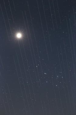
卫星群与夜空之美,作者 Torsten Hansen,德国
图注: 2021 年国际天文学联合会 OAE 天文摄影比赛光污染类第三名。
这幅金星和昴星团的图像还显示了星链卫星的轨迹。这些卫星位于大约 550 公里的高空,是不断扩大的卫星群的一部分,旨在提供全球互联网接入。卫星的反射表面,以及它们围绕地球运行,意味着需要长时间曝光的天文观测会在图像中捕捉到卫星的 "轨迹"。由于测量结果和数据包含这些 "轨迹",这导致用于科学研究的天文图像无法使用。卫星的数量预计会不断增加,在不久的将来,地球上可能再无任何地方能避开这些卫星划过天空的轨迹。这是一种新型的光污染,似乎正成为我们即将要面对的问题,因为这些卫星可能会阻碍对天空的最佳观测。
来源: Torsten Hansen/IAU OAE
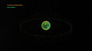
Space debris orbiting the Earth
图注: This animation shows objects orbiting the Earth. The data date from February 2024 and are taken from space-track.org which maintains a public catalogue of objects tracked by the United States Space Command (USSPACECOM).
At first in this video we see green dots, each representing one of the 31,000 human-made objects orbiting Earth. These include both operational and decommissioned satellites, used rocket stages from space launches, and fragments larger than 10cm created by collisions or explosions. Later in the video, some of the green dots are replace by orange dots, each of these representing one of the 9,300 operational satellites orbiting the Earth. Note that since February 2024 more satellites and rockets have been launched in to space and some objects will have fallen back to Earth, so these numbers will have changed.
We see two main groups of objects. The first are those objects orbiting close to the Earth, objects in low Earth orbit. These include communication satellites (many from the satellite constellations used to provide satellite internet services), Earth observation satellites, military satellites, two operational space stations and other objects such as rocket stages and other debris.
More distant from Earth we see a thin ring of satellites. These are in geostationary orbit. This is a special orbit where the orbital period matches the rotation period of the Earth. This means that a satellite in geostationary orbit stays above the same point on the equator and, when observed from the side of the Earth facing the satellite, will appear to stay at a position on the sky that does not change over time. Because of this, geostationary orbit is used by many communications satellites as a satellite dish on Earth used to receive or transmit a signal to that satellite can point in a fixed direction and does not need to dynamically track the satellite. Geostationary orbit is also used by weather observation satellites.
来源: NASA's Scientific Visualization Studio
来源链接
License: PD 公共领域 图标
相关活动
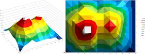
Valleys Deep and Mountains High
astroEDU educational activity (links to astroEDU website) Description: Learn how radar altimetry from satellites works and how to put landscapes on paper.
License: CC-BY-4.0 知识共享许可协议 署名 4.0 国际 (CC BY 4.0) 图标
标签:
Maps
, Earth observation
, Sentinel
, Copernicus
, Remote sensing
, Altimetry
, Radar
年龄段:
14-16
, 16-19
受教育等级:
初中
, 中学
学习领域:
讨论小组
, 建模
, 结构化探究式学习
费用:
中等成本
时间跨度:
2 小时
组别大小:
小组
技能:
分析和解读数据
, 提出问题
, 传达信息
, 开发和使用模型
, 使用数学和计算思维
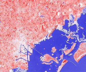
A View from Above
astroEDU educational activity (links to astroEDU website) Description: How do satellites take images of the Earth surface and how do we analyse and use them?
License: CC-BY-4.0 知识共享许可协议 署名 4.0 国际 (CC BY 4.0) 图标
标签:
Maps
, Climate
, Landsat
, Earth observation
, Sentinel
, Copernicus
, Remote sensing
, Vegetation
年龄段:
14-16
, 16-19
受教育等级:
初中
, 中学
学习领域:
结构化探究式学习
费用:
低成本
时间跨度:
1 小时 30 分钟
组别大小:
小组
技能:
分析和解读数据
, 提出问题
, 传达信息
, 构建解释
, 开发和使用模型
, 从证据中进行论证
, 使用数学和计算思维
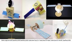
Build Your Own Artificial Satellite
astroEDU educational activity (links to astroEDU website) Description: Build a satellite to learn what they are made of and their uses.
License: CC-BY-4.0 知识共享许可协议 署名 4.0 国际 (CC BY 4.0) 图标
标签:
Art
, Creativity
, Hands-on
, Model
年龄段:
8-10
受教育等级:
Primary
学习领域:
讨论小组
, 互动讲座
, 建模
费用:
低成本
时间跨度:
1 小时 30 分钟
组别大小:
小组
技能:
传达信息
, 开发和使用模型
Where on Earth am I?
astroEDU educational activity (links to astroEDU website) Description: How do satellite-based positioning and GPS navigation work?
License: CC-BY-4.0 知识共享许可协议 署名 4.0 国际 (CC BY 4.0) 图标
标签:
Clocks
, Geography
, Maps
, GPS
, Countries
, Speed of light
, Galileo
年龄段:
14-16
受教育等级:
初中
学习领域:
引导式发现学习
, 问题解决
费用:
低成本
时间跨度:
1 小时 30 分钟
组别大小:
小组
技能:
分析和解读数据
, 提出问题
, 传达信息
, 构建解释
, 开发和使用模型
, 使用数学和计算思维

